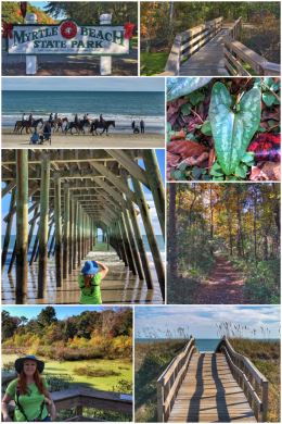
From the Wilmington area of North Carolina, we crossed into South Carolina and landed in Myrtle Beach… just in time for Jenny’s birthday.
South Carolina, the Palmetto State, is the 42nd state we have visited on this massive adventure. It officially separated from North Carolina in 1729, and in 1788, it became the eighth state to ratify the U.S. constitution. On December 20, 1860, it was also the first state to vote in favor of secession from the Union at the start of the Civil War. The state’s capital is Columbia (population roughly 133,000), while Charleston is its largest city with a population of 136,000. The state was named in honor of King Charles I of England — who authorized the English colony; Carolus is Latin for Charles.
Our goal was to spend as much time in nature as possible for Jen’s birthday… which, of course, is pretty much our motto every day. We started with Myrtle Beach State Park — on a quest to finally see more Atlantic Ocean and more beach. The 312-acre park — the first of the state’s parks — is unique in that it contains both a maritime forest and sandy beach. It also includes a nature center (with live animal exhibits) and a fishing pier (shown in the top photo). Interestingly, it is one of sixteen South Carolina state parks built by the Civilian Conservation Corps (CCC). The park includes 278 campsites, 138 of which have full-hookups of water, electricity, and sewer; it also has six cabins.
We started our exploration of the park with the two forest trails, beginning with the .5-mile Sculptured Oak Nature Trail, which is accessed right off the main road into the park. We continued on to a little pond overlook before continuing on to the .4-mile Yaupon Trail, which leads to restrooms and the beach. While on the trails, we saw more beautiful autumn leaves of gold, as well as Live Oak and Southern Magnolia trees, and wonderful Loblolly Pines… but the coolest plant we discovered was the Heartleaf (Hexastylis arifolia), whose name comes from the heart-shaped leaves of this wild ginger; it is also called Little Brown Jug because of its unusual flowers. (One of the leaves is seen in the photo collage above.)
We then walked along the beach and had the perfect luck to watch a group of horseback riders pass right in front of us — for an amazing photo opportunity. (Beach access is available beginning the third Saturday in November and continues through the last day of February for horseback riding.) We walked the beach and collected a shell for our collection before wandering up to the gift shop to pick up a magnet. We had planned to walk out onto the fishing pier, but it is closed for construction through the end of the year. In the end, we hiked/walked about 1.5 miles in the park.
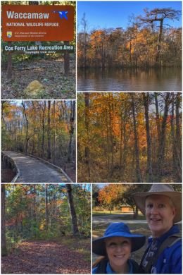
We then traveled about 20 miles northwest to the Cox Ferry Lake Recreation Area of the Waccamaw National Wildlife Refuge, which was established in 1997 to preserve valuable undeveloped coastal wetlands and adjacent upland forests that provide habitats for many species of wildlife.
Located in portions of Horry, Georgetown, and Marion Counties, the Waccamaw National Wildlife Refuge’s acquisition boundary spans close to 55,000 acres and includes large sections of the Waccamaw and Great Pee Dee rivers and a small section of the Little Pee Dee River. The refuge’s visitor center is located in
Georgetown, about 35 miles southwest of Myrtle Beach.
The 325-acre Cox Ferry Lake Recreation Area is located on Gary Lake Boulevard, off S.C. Highway 544, not far from the Coastal Carolina University campus. It offers three miles of interpretive nature trails, a mountain biking trail, boardwalk, kiosks, and a weather shelter with picnic tables. We parked at the first parking area — the Jackson Bluff Trailhead parking — just past the NWR sign. We hiked a series of trails (including the green, yellow, and blue trails), which leads to a fishing area along the Waccamaw River… with a roundtrip total of about 3.2 miles. (The Waccamaw River is about 140 miles long and drains into the Atlantic Ocean — and passable only by canoe or kayak.)
From Myrtle Beach, we traveled to the Columbia area and a small family campground where we hoped to spend a quiet Thanksgiving… although the park was chosen mainly for its proximity to Congaree National Park, which coincidentally was the 42nd national park we visited — and which you can read about in our previous post. We loved the quaintness of River Bottom Farms Family Campground, but their WiFi was pretty weak and could be improved.
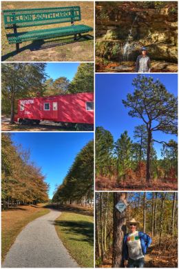
We spent Thanksgiving much like Jen’s birthday — out in nature — starting with a very short (1.6-mile RT) paved rail-trail we discovered in the tiny town of Pelion. The town is best known for its annual Pelion Peanut Party — an autumn tradition when the townspeople gather for the annual boiling of the peanuts. Members of the Pelion Ruritan Club, using a secret recipe, continue the tradition at the annual Pelion Peanut Party — and they are more than happy to share the final product with festival-goers.
We then traveled to Peachtree Rock Heritage Preserve, located about 30 minutes from downtown Columbia, in Lexington, SC. It was acquired by The Nature Conservancy to protect, conserve, and enhance the integrity of one of the largest sandstone outcrops in South Carolina — as well as the only waterfall in the Coastal Plain… and a beautiful Longleaf Pine ecosystem. The Nature Conservancy works with the South Carolina Department of Natural Resources (SC-DNR) to maintain the trails within the 460-acre park.
The “big rock” for which Peachtree Rock Heritage Preserve was named took the shape of an inverted pyramid, balanced on its tip. This unusual silhouette was created when the waters of the Atlantic Ocean receded long ago. Erosion, storms, and visitors carving into the rock gradually wore away at that fragile pedestal, and on December 7, 2013, a hiker observed that Peachtree Rock had toppled. Still, it is amazing to see it and other rocks riddled with the fossils of ancient marine creatures.

We came home and Ran cooked his Spicy Thai Red Curry Chicken Recipe — but used oven-roasted turkey breast instead of chicken since it was Thanksgiving! We also opened a bottle of Randall’s Point Red from one of our favorite wineries to add a bit more festiveness to the dinner… and we had Ran’s keto-friendly, no-sugar pumpkin pie (which was made fresh and organic) for dessert.
We would have liked to have the traditional roasted turkey for our dinner, but while our little trailer is pretty wonderful, the oven is both a bit temperamental and small — and no way could we roast a turkey. (We bought a small turkey roast from Costco.) You know what? On a cool day in South Carolina, a big bowl of this turkey curry was just the perfect meal — a true thanksgiving for the day we had spent in nature, for the year we have spent on the road exploring this amazing country, for our mental and physical health and well-being, for kind and supportive friends and family, for this love that we share, and for God’s grace and mercy.
From Columbia, we traveled to Yemassee, in southeast South Carolina — a perfect location from which to visit Charleston, as well as dip into Georgia and visit Savannah. We stayed at a very fine KOA, Point South KOA, which has nice facilities, a great hiking trail, and amazingly strong WiFi.
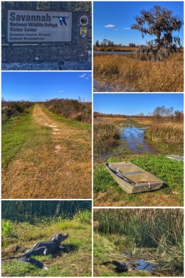
We started our adventures in the area with a visit to the Savannah National Wildlife Refuge, a 31,000-acre refuge that is almost equally split between South Carolina (15,263 acres) and Georgia (15,395 acres). The refuge consists of freshwater marshes, tidal rivers and creeks, and bottomland hardwoods. About half the refuge is bottomland — forested primarily by Cypress, Gum, and Maple trees. The refuge, which consists of former rice fields from plantations dating back to the mid or late 1700s, was established to provide sanctuary for migratory waterfowl and other birds and as a nature and forest preserve for aesthetic and conservation purposes.
We started at the visitor center, located about 17 miles north of Savannah, chatting with an employee about the best trails to hike… we also bought a magnet and happily discovered — and watched — a short film about the refuge. We discovered that waterfowl are most abundant from November through February, while alligators and other reptiles are frequently seen from March through October. We also learned that all the trails (including the Laurel Hill Wildlife Drive, a 4-mile auto-tour route currently closed and undergoing renovations) are located about three miles from the visitor center. (Technically, there are a few trails at the visitor center, but these are not representative of the wildlife refuge — just a few short loops in the woods.)
We drove to the Tupelo Trail Parking area and hiked parts of the Tupelo Trail and Little Back River Trail — which provided us with views of the Little Black River and the Diversion Canal… and more importantly, allowed us to have a few close encounters with nine alligators — including one who refused to move from the trail! In total, we hiked about 4 miles.
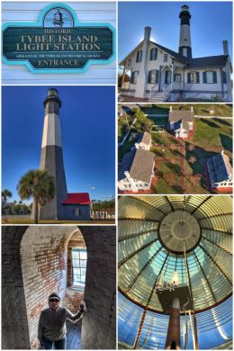
Next up was getting another lighthouse fix by visiting the Tybee Island Light Station. (It’s called a light station when there is an entire complex of buildings and housing for the light-keepers.) The Tybee Island Lighthouse is one of seven surviving Colonial-era lighthouse towers, although it is now in its fourth “life” — having been modified multiple times since it was first constructed in 1736. It is Georgia’s oldest and tallest lighthouse. The tower stands 145 feet tall and has three Light Keeper’s Cottages as part of the complex. A small 1812 Summer Kitchen holds archaeological finds. Across the street is an 1899 Military Battery that houses the Tybee Island Museum.
Tybee Island is a barrier island located just east of Savannah — and the lighthouse is located on the northeast side of the island. The lighthouse beacon, containing a 1st Order Fresnel Lens, is still used as a navigational aid — and maintained by the Coastguard — but the lighthouse and grounds are maintained by the Tybee Island Historical Society. Self-guided tours of the grounds require a fee, but the buildings and the climb to the top of the lighthouse (only 178 steps!) are definitely worth it. There’s also a small gift shop (located in the restored 1930s Light Station three-car garage). If you go, make sure you park in the parking lot, as all of Tybee Island charges for on-street parking.
Along the way, if we had time, we could have visited Fort Pulaski National Monument, an old Civil War fort located on Cockspur Island, between Savannah and Tybee Island.
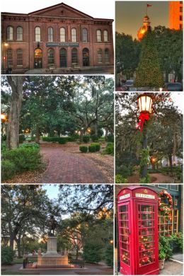
Instead, we continued on into Savannah — on a quest to explore some of the city’s 22 historic squares. (The Savannah Historic District, planned by Georgia-founder James Oglethorpe, was declared a National Historic Landmark District in 1966 — one of the largest districts of its kind in the U.S. At its southern end is the 30-acre Forsyth Park.)
Savannah was established in 1733 along the Savannah River — and is the state’s oldest city. It was also the British colonial capital of the Province of Georgia — and later became the first state capital of the state of Georgia.
We started in the city’s visitor center, located along Martin Luther King Jr. Blvd., in the old red-brick passenger terminal of the Central of Georgia Railroad complex. The building is also home to the Chamber of Commerce and the Savannah History Museum. Built in the mid-1800s, the railway used the beautiful building until 1972. The visitor center also is a good place to park, as parking in the historic area is often a bit tricky. With only about an hour or so of daylight, we chatted with a tour guide who suggested that we visit at least two squares while in town: Chippewa Square and Wright Square.
Chippewa Square is home to the memorial to city founder James Oglethorpe, but for movie buffs, it may be more well known as the place where Forrest Gump sat on a bench sharing his life story with folks waiting for a bus in the hit 1994 movie.
Wright Square, one of the original four squares laid out in Savannah, is home to a towering statue and an enormous boulder, but it is perhaps more infamous as the “Hanging Square” where the hanging of Alice Riley took place. Riley was an Irish immigrant who some say was the first woman to be executed in Georgia; her ghost is said to haunt the square. In terms of the main features of the square, the central monument honors William Washington Gordon, the founder of the Central of Georgia Railroad, and the large boulder in the southeast corner memorializes Tomochichi, the leader of the native Yamacraws, a friend of General Oglethorpe and ally of the English, whose body was buried in the square.
Savannah is a very popular tourist location, with lots of history and culture, and we had a fun visit, but we are not about crowds or shopping or ghosts … so the short visit was fine with us.
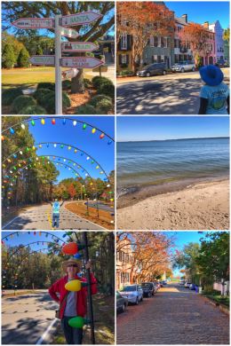
We spent our last day in South Carolina visiting Charleston and the surrounding area. Charleston is the oldest and largest city in the state — founded in 1670 as Charles Town, honoring King Charles II of England. The city was one of the major keys for the colonization by the British and served a key role as the hub of the slave trade. Today, the town and surrounding area is known for its historic former plantations (including Boone Hall, the most photographed plantation) and well-preserved architecture. While we had no interest in visiting a plantation, we did decide to visit Rainbow Row, one of the most photographed areas of the city. It consists of 13 (some ay 14) pastel-colored Georgian row houses located on East Bay Street in the southeast part of the city. The houses, built in the 1740s, are located in what was the waterfront district — and were owned by merchants who ran stores on the ground floor and lived above them. As you can see in the photo collage, a number of the side streets are still paved in the original cobblestone.
Other things to see in Charleston include King Street, the most unique Main Street in the world — a major shopping and dining district — which held no interest to us. The Battery and Waterfront Park are other options, but we decided to leave the crowds and head to the 643-acre James Island County Park, located about 6 miles southwest of the city… on James Island.
James Island County Park is a pretty neat place — and during the holidays it is transformed into a magical holiday land, with more than 2 million lights showcasing all sorts of animals and scenes along a 3-mile driving tour. It also includes Santa, special Christmas shops, a festive train ride, and more holiday activities. We visited during the day, when it was peaceful, but kind of wish we had spent at least one night here — as they do have a campground with pull-thru, back-in, and tent sites (all with power and water) — so that we could have witnessed the massive spectacle of lights! (The campground also includes a camp store, laundry, bathrooms, and WiFi!)
We enjoyed a nice hike along the Orange and Blue Trails, which cover a large section of the park — for a total of about 2.5 miles. All the trails in the park are paved, which makes them much better for biking than hiking.
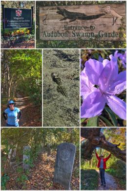
We ended the day on the grounds of a historic plantation — Magnolia Plantation — but we were not there for the mansion or the gardens, but to hike through the Audubon Swamp Garden, a 60-acre Cypress and Tupelo swamp that at one time served as a reservoir for the plantation’s rice cultivation. It is named for ornithologist and artist John James Audubon, who visited the plantation before the Civil War (and reportedly collected several waterfowl specimens to serve as models for his paintings.) It’s a haven for waterfowl (including Anhingas, a relative of the cormorant), turtles, snakes, and alligators. The trail is a combination of dirt paths and raised boardwalks… truly a fun exploration — and relatively short at about 1.75 miles.
A fun bit of trivia: the 1982 horror film Swamp Thing, directed by Wes Craven, was filmed in the Audubon Swamp Garden.
Magnolia Plantation was founded in 1676 by the Drayton family — and is still owned by a direct family descendant. It is the oldest public tourist site in the Lowcountry, and the oldest public gardens in America, opening its doors to visitors in 1870 to view the thousands of flowers and plants in its famous gardens — though many parts of the gardens are even older, some sections more than 325 years old, making them the oldest unrestored gardens in America. It also contains the last large scale Romantic Gardens left in the United States.
One final interesting discovery we made while visiting eastern South Carolina is the Atlantic Intracoastal Waterway, a protected, all-season waterway that runs for more than 200 miles in the state and is dredged to an average depth of 9-11 feet. The Atlantic Intracoastal Waterway was authorized by Congress in 1919 and completed in 1940 and extends more than 1,100 miles from Norfolk, Virginia to Key West, Florida. Some lengths of the waterway consist of natural inlets, salt-water rivers, bays, and sounds; others are man-made canals. The U.S. Army Corps of Engineers is responsible for maintaining the waterway.
Next up? We dip briefly further into Georgia on our way to a month in Florida!
