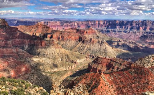
 When we visited the Grand Canyon (National Park #3 on our adventure) back in February of this year, the North Rim — the Kaibab Plateau — was unreachable because of heavy snow… so it has been in the works for months to make the trek back to this amazing natural wonder. And if you were wondering, the North Rim is more than 1,000 feet higher in elevation than the South Rim, and snow covers much of it for half the year. The Grand Canyon is 277 miles in length and considered by many to be one of the seven wonders of the natural world. It became a national park in 1919 when President Woodrow Wilson signed the law that was decades in the making. The park encompases 1,217,262 acres.
And while just about everyone is awed by the Grand Canyon’s South Rim, we just have to say that the North Rim is simply just as amazing (and perhaps more), with great hikes and overlooks — and much fewer people! The North Rim (and by default the Grand Canyon) knocked us over with its beauty — and the park quickly rose onto our short list of favorites (along with Theodore Roosevelt, Glacier, and Great Basin).
A stop to the visitor center is not necessary (as it is pretty darn small), but you should stop in this area of the North Rim so you can hike to Bright Angel Point — a .5-mile (RT), steep, but very doable paved trail.
 After the short hike and a quick stop to mail a postcard to (Jenny’s) Mom, we headed up the very scenic Cape Royal Road — driving all the way to Cape Royal (and the Angel’s Window) before turning back and stopping at all the key overlooks, including: Walhalla Overlook, Roosevelt Point, Vista Encantada, and Point Imperial.
Our favorite hike had to be the Cape Royal Trail — a .8-mile (RT) paved trail that includes excellent interpretative signs, as well as great vistas of Angels Window, the Colorado River, and the Canyon. Lots of other hikes abound, including a portion of the Arizona Trail. And if you were wondering, yes, it was chilly that day!
 Also spectacular was the drive down to the North Rim from where we were camping in Page, Arizona. Driving along US-89A we encountered Marble Canyon and the inspirational Vermillion Cliffs National Monument. Established in 2000 by President Bill Clinton, this 293,689-acre park protects the Vermilion Cliffs, Paria Plateau, Coyote Buttes, and Paria Canyon — and is managed by the Bureau of Land Management (BLM). While there is no visitor center, you will find plenty of pull outs along the highway to enjoy these colorful cliffs.
 Near Jacob Lake, we turned onto AZ-69, which takes you directly into the North Rim. This drive, especially now in Autumn, is breathtakingly beautiful — a drive through evergreen forests and massive aspen groves of the Kaibab National Forest, which actually borders both the North and South Rims of the Grand Canyon and is about 1.6 million acres in size. (FYI: Aspens often are the first trees that come back after a forest fire because they can sprout from existing roots — and thus grow faster than the slow growing conifer saplings… and there was a massive burn in this part of the national forest some years ago.)
 One other interesting thing to see on US-89A — between Bitter Springs and Jacob Lake — is the Navajo Bridge, a National Historic Civil Engineering Landmark located in the Glen Canyon National Recreation Area. Actually, it’s two bridges that span the Colorado River — one historic and one new — which represent one of only seven land crossings of the Colorado River for 750 miles. The original (historic) bridge, completed in 1928, was first known as the Grand Canyon Bridge before the Arizona legislature officially changed it to Navajo Bridge in 1934. The new bridge was completed in 1995 — designed to match the original — but built to handle the increased traffic on the highway.
We stayed in Page, AZ, on this leg of the trip — and while we loved the location, we hated the traffic and congestion… even our cell service was impacted by the how many people are in this small space.
 Speaking of too many people, Jenny spent a good amount of time researching the best times to visit a very popular tourist attraction so that we could avoid the crowds — and it worked! We decided to visit Horseshoe Bend very early in the morning, both for the better light conditions for photos and so that we would be assured a parking space. Horseshoe Bend is also part of the Glen Canyon National Recreation Area, and is a horseshoe-shaped meander of the Colorado River. Be prepared for a bit of a hike (1.5 miles RT, with some very sandy soil), but the vista over the river — at about 1,000 feet — is amazing! The cliff walls are spectacular, and contain a variety of minerals (including garnet, hematite, and platinum).
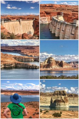 The next and final day of this stop, we decided to check out the Glen Canyon Dam and Lake Powell, as well as plan a hike. The dam has a great visitor center and offers tours of the dam, but we opted for nature over a dam structure. The 710-foot high dam was completed in 1966 and created Lake Powell, one of the largest man-made reservoirs in the U.S. Lake Powell (like many other dammed lakes) covers the original Colorado River and the many glens (deep sandstone gorges) that are deep below the surface — even if the water level looked pretty low — but the drive along Lake Shore Drive is certainly worth it. Take a right off of Highway 89 right after the visitor center and drive it all the way up to Wahweap.
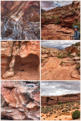 Our day ended with a 4-mile (RT) hike up a sandy wash to a sandstone arch. The Bucktank Draw and Birthday Arch Trail is wonderful in several ways. First, the scenery of the rock is beautiful. Second, the trail is not that well known — and thus unpopulated; in fact, the trailhead is unmarked and hikers can only find it by finding a small metal gate located off Highway 89 (in Utah) between mile markers 9 and 10. Hiking in the wash, a combination of sandy and smooth, sculpted bedrock as its course twists and turns, is certainly a worthy adventure — just do not try it in stormy weather!
Of course, everyone visiting Page seemed to want to see Antelope Canyon and The Wave… but we like to go against the grain and visit less popular/trendy locations.
Next up we head to Hurricane, UT, and a visit to Zion National Park!