
 Our hunt for more crazy sandstone buttes and towers led us to the Utah-Arizona border — and directly into Monument Valley and to a little campground at Gouldings (on the Utah side of the border) — a compound that started as a trading post for the Navajo people and now includes a hotel, campground, gas station, grocery store, and museum … and even nightly showings of movies about the area in a small theater. The Gouldings are the folks who immortalized this area as the true west in film by enticing John Ford to come and shoot westerns (many starring John Wayne), starting with the award-winning Stagecoach. (There are also nightly showings of John Wayne movies at Gouldings.)
 Monument Valley is not really a valley — and it is much larger than the image most folks have of it. Most people know the image from US-163 heading south toward the Utah-Arizona border — of a straight highway leading to giant red sandstone buttes and spires (as in Jenny’s photo here) … but it is much larger than that view… and much larger than what you can see when visiting the 92,000-acre Monument Valley Navajo Tribal Park. That said, you must consider driving (or taking a guided tour) the 17-mile scenic dirt road that takes you near some of the most famous of the monuments, including The Mittens, Three Sisters, Elephant Butte, Camel Butte, and Totem Pole. (While there is a $20 admission fee to the park and visitor center, because it was overcast that day — or so we assume — we got in free. Score! To compensate, we bought a few things in the gift shop, including a Navajo dreamcatcher.)
 A smaller version of Monument Valley can be found on Bureau of Land Management (BLM) land also off US-163, near Mexican Hat, called the Valley of the Gods. This very cool landscape of mesas, buttes, towers, and mushroom rocks had previously been part of Bears Ears National Monument, but happily is still protected.
The 17-mile scenic drive is very much worth the effort, but be forewarned that while the road is graveled, it also goes through multiple washes — so a high-clearance and 4-wheel drive is recommended. We visited it the night before the rains of Tropical Storm Rosa visited the area, dumping steady rain and raising concerns of flash flooding in the area.
As a bonus, near sunset, we drove up UT-261, a partially paved roadway, all the way up 1,200 feet to the top of Cedar Mesa at Moki Dugway… just amazing views from the top of the mesa!
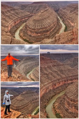 We concluded our time here with a visit to Goosenecks State Park, one of the smallest state parks we have ever visited — but one with such spectacular visitas that the size does not matter… the result of 300 million years of geological activity in which the San Juan River winds and carves its way through the desert 1,000 feet below.
This park offers some of the most amazing views of an entrenched river meander — called goosenecks because the sinuous canyons and valleys resemble the curved neck of a goose. At this location, the San Juan River twists and turns westward through the meander, flowing a distance of more than six miles while advancing only one-and-a-half miles on its way to Lake Powell.
Next up? Going back to one of the first national parks we visited so that we can partake in visiting the North Rim of the Grand Canyon National Park — part of the park neither of us has visited before!