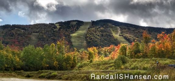

Autumn in New England definitely is amazing, and our time in Vermont and New Hampshire was absolutely wonderful.
The leaves on the trees — the golds, oranges, and reds — were simply spectacular and a memory we will definitely cherish. If you have New England in autumn on your bucket list, now is the time to start putting that visit into your planner… Make it happen!
Upstate New York was amazing, but Vermont — and especially New Hampshire — took the colors to new levels, and we often found ourselves stopping on the trails and just soaking up all the trees and colors. Happily, the crowds — those other Leaf Peepers like ourselves — were not too bad. The campgrounds where we stayed were not especially crowded, nor were the roadways.
We did not use a map or other forecasting tool to find that “peak” moment… we just used research and hoped for the best… that the crazy weather this spring and summer did not have too drastic affect on the timing… We were also on a timetable, as most campgrounds in the New England area close for the season on or near Columbus Day.
Vermont
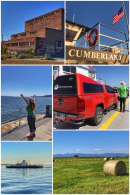
We started our adventures in Vermont — state #32 — in Burlington, crossing over on two different ferries (while still technically camping in upstate New York). We did a loop, starting with the southern most ferry on Lake Champlain, departing from Essex and arriving in Charlotte, Vermont… a 3-mile, 25-minute ride on the Gov. George D. Aiken (built 1975; named after the former governor of the state and U.S. Senator). On the return trip, we crossed at the northern most point on the lake, traveling from Grand Isle, Vermont, to Plattsburgh, New York, a 15-minute ride on the larger Cumberland (built 2000 to run in ice; named for Cumberland Head, the specific location of the Plattsburgh ferry slip).
Fun fact: Lake Champlain is the thirteenth-largest lake in the United States, reaching a maximum width of 12 miles and depths of more than 300 feet. It has three ferry crossings — and one bridge, along U.S. Highway 2 just south of the border with Canada.
We spent some time exploring Burlington, including some shopping for organic items at the Healthy Living Market and Trader Joe’s. We also walked around in the Waterfront Park area, including a bit on the Island Line Trail. (Also located there is the ECHO, Leahy Center for Lake Champlain, a kid-centered museum.)
Burlington is Vermont’s most populous city, with a population of about 42,000+ people. Fun fact: In 2015, Burlington became the first city in the U.S. to run entirely on renewable energy.
One other option for things to see in the area is the Ben & Jerry’s factory in Waterbury, located about 30 miles east of Burlington. Back in 1978, the ice cream enterprise was founded in a renovated gas station… and sold in 2000 to British-Dutch conglomerate Unilever.
And if you had more time in Burlington, then a trip to Stowe, about 35 miles east, might be of interest. Stowe Mountain is the state’s highest peak, and a resort there offers gondola rides to the top and ziplines back down… and of course, skiing in the winter.
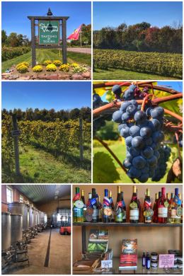
We were more interested in wine-tasting, so of course made a stop at Shelburne Vineyard, a small winery that produces wines from northern varietal grapes (including their signature estate Marquette grape) grown in their 17 acres of vineyards, as well as regionally sourced from other northern growers. Their tasting room is beautiful — and a LEED-designed building, just one part of their commitment to sustainable practices in all aspects of the business.
We decided to do two types of tastings, starting first with a flight of their red and white wines ($9 for the taste, including a souvenir wine glass), which were very nice. We then did their Wine & Cheese Pairing ($18 per person), which included two whites, a rose, and one red — all paired with a mix of cheeses. We had a delightful time, but none of the wine nor cheese spoke to us enough to purchase.
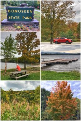
Next up was a bit of camping — still in western Vermont — along Lake Bomoseen, a naturally formed lake… and the largest lake that lies entirely within the state’s boundaries, with a surface area of approximately 2,400 acres. We stayed at the Lake Bomoseen KOA Holiday — and loved having the one section of the campground almost all to ourselves; we also had great WiFi and nice bathrooms.
We started our adventures with the lake, of course, checking out the
3,576-acre Bomoseen State Park, which opened to the public in 1960. The park is located in the Taconic Mountains on the shores of Lake Bomoseen — and highlights the rise and fall of the Vermont slate industry
with several quarry holes and their adjacent colorful slate rubble piles as reminders of this period. Part of what is now the park was owned by the Lake Shore Slate Co. (A self-guided Slate History Trail leads hikers through remnants of this bygone era.) When open seasonally, the park has a campground, a beach for swimming and a picnic area. A snack bar concession stand and boat rentals (canoe, kayak, row, and pedal) are available at the beach. The park was already closed by the time we visited, so we parked just outside and hiked around inside, exploring various trails and roads.
Next up was an adventure to see more autumn colors by driving about 30 miles east to Killington, a town in the Green Mountains of central Vermont, an known for the Killington and Pico Mountain ski resorts. Killington Mountain is the second highest peak in Vermont, at 4,229 feet. Killington is a stop on the Long Trail — a 273-mile trail that is the oldest long-distance trail in the U.S. (constructed from 1910 to 1930 by the Green Mountain Club); the Appalachian Trail follows the Long Trail here.
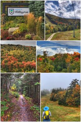
The drive alone was beautiful — and we had hoped the gondola ride to the top of Killington Mountain would provide some awesome vistas; instead, we not only got fogged in by the clouds, but it poured rain twice! (Fun fact: Killington is the largest ski area in the eastern U.S., and has the largest vertical drop in New England at 3,050 feet.)
We jumped on the K-1 Express Gondola ($27 per person) for the ride to the top. At the top, we took refuge from the first rain in the Peak Lodge (elevation 4,241 feet), which was built in 1967, but totally redone in 2014 as a green building. (A sign says that Vermont cows generate all the electricity for the building.)
We had planned to hike several miles of the 15 miles of designated hiking trails on the mountain, but when the clouds opened up for a second time, we cut the hike short and jumped on the gondola for the ride back down. We did get in a few miles on the Wildlands Trail and Warbler Trail — but decided to skip the Summit Trail because of the rain.
From Lake Bomoseen, we headed east along US-4 through the quaint town of Woodstock, Vermont, which we had never heard of until driving through it. Upon further research, we discovered it has been called the Quintessential New England Village — and indeed it is full of charming Americana, including a covered bridge in the center of town and a village green surrounded by restored Georgian, Federal Style, and Greek Revival homes.
Other fun facts about Vermont? It is known as the Green Mountain State. Named by the French, it literally means green (vert) mountain (mont). It leads the nation in the production of monument granite, marble, and maple products. In fact, the state tree is the sugar maple… and its official insect is the honeybee. The state motto is: “Vermont, Freedom and Unity.”
New Hampshire
From Vermont, we pressed onward, crossing into New Hampshire and settling in at a nice little RV park in along the Soucook River in Loudon: Cascade Campground. (The Soucook River is a 29-mile-long river and a tributary of the Merrimack River.)
Our first adventure in New Hampshire — state #33 — was exploring the Merrimack River by hiking the Les Clark Nature Trail located in the 103-acre Merrimack River Outdoor Education & Conservation Area, which is a floodplain area. The short 1.5-mile hike is unique because it takes you through a pine forest (planted in the 1960s), a maple-oak-hickory terrace community, and a native silver maple floodplain forest.
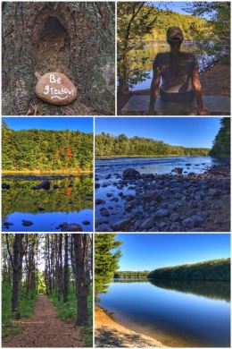
We then drove about six miles north over to the 135-acre Sewall’s Falls Recreation Area (boat launch parking area) to continue our hiking — again hiking right along another section of the Merrimack River. The Sewalls Falls Park Trail follows right along the banks of the river for a wonderful hike. (The “falls” are more rapids, and also the location of an old hydro-power dam.) The almost 3-mile (out and back) trail is flat and easy to hike — and features fun and inspirational painted stones people place along the trail.
Next up it was time to get some elevation again, this time with a hike in Rollins State Park, located at the southern base of Mount Kearsarge — an inselberg, which is an isolated small mountain that rises abruptly from the surrounding plain. The name of the mountain comes from the native Pennacook name for the mountain, Carasarga, meaning “notch-pointed-mountain of pines.” And, of course, we discovered that work crews from the Civilian Conservation Corps (CCC) helped in the development of the state park!
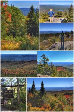
(Winslow State Park is located on the northern base of the mountain — and both parks are located within the 5,000-acre Kearsarge Mountain State Forest and part of the Merrimack River watershed.) The highest point on Mount Kearsarge is 2,937 feet.
We took the 3.5-mile long scenic auto road from the park entrance through beautiful woodlands up to the parking and picnic areas. The drive is wonderful and the views from the parking area quite nice… but there’s a fire tower on Mount Kearsarge, so we then hiked the .5-mile Rollins Summit Trail. (One can also hike up or down via the Lincoln Trail, which is slightly shorter but much steeper.) Once at the summit we stopped and enjoyed the views and marveled at a crew of workers who were busy doing upgrades on the fire tower. The views of New Hampshire and Vermont were wonderful, but unlike what the guidebook says, we saw no evidence of views of Boston. We then decided to hike a bit more, crossing over to the Winslow side and hiking a mile or so on the Barlow Trail. FYI, the hikes from Winslow State Park are both longer and steeper than from the Rollins side. From Rollins, the elevation gain is about 330 feet, but from Winslow it is more than 1,000.
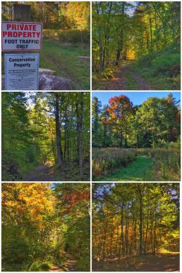
We were still looking for a bit more hiking after Mount Kearsarge, so we headed over to the Great Gains Memorial Forest, located on Montgomery Road… just past the Daniel Webster Birthplace State Park on North Road in Franklin. Great Gains Memorial Forest is a sprawling woodlands with many conservation easements, offering numerous hiking options… though also confusing options, as we could never find a map or any details about any of the trails.
The drive over to the forest from Mt. Kearsarge continued our love-hate relationship with Google Maps, as the dirt road (Quimby Road) we started on quickly became a one-lane, rock-plagued road that had Jen gripping the steering wheel and Ran trying to keep her calm; the road literally become nothing more than a barely-passable logging road — and yet Google Maps listed it as the PRIMARY road to take to get to our destination. Scary… and thank goodness we did not have the trailer on that drive!
Some fun facts about New Hampshire. It’s name comes from the county on the southern coast of England (Hampshire). It is known as the Granite State. The state motto is “Live free or die.” The state’s official emblem comes from a mountain… the “Old Man of the Mountain” granite head profile (which sadly fell from its perch in Franconia in 2003). The state is also home to
Mount Washington (called Agiocochook by some Native American tribes), the highest point in New England at 6,288-feet; Mt. Washington is infamous for having the worst weather in North America.
The next day it was time to move to the more “pretty” area of New Hampshire (at least according to one of our friends who lives there)… up to the White Mountains, staying at a fine KOA in Tamworth: the Chocorua KOA.
We only had two days in this area because we were looking ahead at our calendar and trying to get maximum autumn views while also having a place to stay before that Columbus Day campground closing deadline.
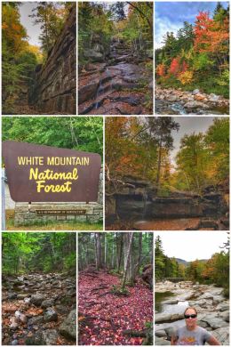
We decided to head up NH-112, a very popular route for leaf-peepers and known as the Kancamagus Highway — a National Scenic Byway — into the White Mountain National Forest (established in 1914). The national forest contains more than 800,000 acres in New Hampshire and western Maine. More than 100 miles of the Appalachian Trail travels through the national forest.
There are numerous overlooks and turnoffs along NH-112, but we were focused on getting to Champney Falls, located about 23 miles north of Tamworth (and 11 miles west of Conway). The hike is about 3 miles (RT), with an elevation gain of roughly 800 feet. The trail goes through the forest and offered wonderful fall foliage. The waterfall at the end is truly lovely — even though it was quite small and more of a trickle than a waterfall… but we could imagine how roaring it would be in the spring during the snowmelt. The trail is named for Benjamin Champney, a pioneer White Mountain Artist (1817-1907). For those wanting a much more challenging hike, the trail splits and one can hike to the summit of Mt. Chocorua, an eight-mile hike with a 2,300 elevation gain.
We also snuck in some wine-tasting… of course! We tasted both at Whippletree Winery, just a few miles from the KOA. We had a nice tasting there, but none of their wines made our toes tingle — though we liked that their wines are produced with minimal processing. We also had a blast tasting at Seven Birches Winery in Lincoln (not far from Loon Mountain). They specialize in producing wines from classic European grape varietals and locally sourced fruits. We tried all their reds — produced from Chilean grapes — but left with a bottle of their Blueberry wines, which we found very delightful.
The next day we met up with long-time friend Louise and her boyfriend Leigh for more fun adventures in the White Mountains, this time centered on the Cannon Mountain area. Ran and Louise went to Syracuse University together and even both worked in New York City at the same time before going in different directions; in other words, while they have been in contact all these years, this was the first time seeing each other in about 30 years!
Louise and Leigh treated us to a fun combo package called the Franconia Notch State Park Discovery Pass, which includes a roundtrip on Cannon’s Aerial Tramway and admission to the Flume Gorge. Franconia Notch State Park is located in the heart of the White Mountain National Forest. Franconia Notch is a spectacular mountain pass traversed by a unique parkway which extends from the Flume Gorge at the south to Echo Lake at the north… for eight miles, I-93 winds between the high peaks of the Kinsman and Franconia mountain ranges (some of which you can see in the middle-right photo in the collage below).
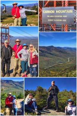
We started with Cannon Mountain, which is a 4,100-foot peak with a ski resort; it was home to the Old Man of the Mountain, until that formation collapsed in May 2003.
We rode the 80-passenger cable car up to the 4,080-foot summit on a perfectly clear day — with a conductor who was quite amusing, sharing stories of the ski resort. The tram has been in operation here since 1938!
On at the top, you can go directly to the observation tower or hike the rim trail around the summit for some amazing panoramic views. As we hiked along the trail and then up on the observation tower, we enjoyed views of the mountains of New Hampshire, Maine, Vermont, New York, and into Canada. It was crazy windy along the summit — and especially on the observation tower. (The summit also includes a cafeteria and restrooms.)
There are restrooms and a gift shop at the base of the tram. (In fact the gift shop is where the pioneering tram originated.) We, of course, stopped to look at magnets and ended buying two for our collection!
In the winter, Cannon Mountain is open with 97 trails and slopes for all abilities. Cannon Mountain is also the home of the New England Ski Museum, which is located near the base of the tramway, and has some interesting exhibits (including Olympic medals).
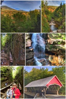
We then drove south to the Flume Gorge. We started in the visitor center, learning more about the gorge itself — a natural granite gorge discovered in 1808 by 93-year-old “Aunt” Jess Guernsey; it sits at the base of Mount Liberty (a 4,459-foot high mountain).
The park is only open from mid-May to mid-October.
We hiked the 2-mile loop trail so that we could experience everything the park offers — including towering moss-covered granite walls, cascading waterfalls, historic covered bridges, glacial pools and boulders, and beautiful trees and woodlands.
Cut by Flume Brook, the gorge features walls of Conway granite that rise to a height of 70 to 90 feet and are 12 to 20 feet apart. Knowing this information, you can imagine that the trail includes boardwalks, stairs, and a lot of uphill (and then downhill) hiking. Still, it is a fairly easy hike.
At the top of the gorge sits Avalanche Falls, a 45-foot waterfall that creates a roaring sound as the Flume Brook enters the gorge. The falls were formed during the Great Storm of 1883, which washed away a hanging boulder. (The boulder was never found.)
The red covered bridge (shown in the collage), which was built in the 1886 and has been restored several times, goes over the Pemigewasset River. Pemigewasset means swift or rapid current in the Abenaki Indian language.
We ended the day with a nice dinner in Conway and said our goodbyes…
And the next day we prepared to head to Maine and Acadia National Park!