
From Oswego in Central New York, we continued eastward traveling first to just south of the Adirondacks, arriving in Saratoga Springs.
Our first order of business was to get back on our bicycles before it gets too chilly to enjoy riding them… and we found the perfect rail-trail to explore in the Warren County Bikeway, a 10-mile trail that runs from Glens Falls to Lake George.
It is among the earliest rail-trail conversions in the country, with the project beginning back in 1978. It follows a branch of the Delaware & Hudson Railroad that was used to transport vacationers to Lake George — nicknamed the Queen of American Lakes — a 32-mile long lake located in the east-southern section of Adirondack State Park; the lake is part of the St. Lawrence watershed and has a surface area of about 45 square miles. The area is a massive tourist area, with summer populations swelling the area population by 50,000! (Luckily, we missed most of those folks by visiting in late September!)
We parked the truck at the Northern Terminus of the trail along Round Pond Road in Queensbury, as a chunk of the route from Glens Falls runs along the road. The route we took was especially beautiful as it traveled through a hardwood forest for five miles until reaching the outskirts of Lake George. The trail eventually ends in Battlefield Park on the southern shores of Lake George. We were also touched to discover signs for suicide prevention along the trail, which were explained when we found a memorial for Sergeant Kristie Roberts, a New York State Army National Guard Medic, as well as a community volunteer and private sector paramedic.
For folks who like crazy long bike rides, the Warren County Bikeway ends near the Feeder Canal Park Heritage Trail (some of which we hiked), which then connects to the Champlain Canalway Trail (which is part of the state’s developing Empire State Trail, a multi-use trail that will span 750 miles — running from Manhattan north to the northern tip of Lake Champlain and also from Buffalo to Albany.)
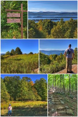
The next day it was time to gain some elevation, so we decided to hike the Pilot Knob Ridge Preserve trail, which climbs about 1,000 feet up a ridge overlooking Lake George. The parking area for the trail is located near Warner Bay on Pilot Knob Road.
The trail is a long, winding route that has been upgraded with steps on many of the steeper portions. The hiking through the hardwood forest (eastern hemlocks, American beeches, yellow birches, sugar maples, red maples, red oaks, and white pines) is simply beautiful. And the most amazing part is that at the top of the ridge there’s a gazebo to sit and reflect on the views of glimmering Lake George and the Adirondack Mountains beyond. From parking lot to gazebo and back was 1.6 miles. There’s an additional 2-mile trail at the top that leads to a seasonal waterfall, which we did not hike because we were told the waterfall was dry in the fall.
The 223-acre preserve is forever protected after the Lake George Land Conservancy (LGLC) bought the property in 2000. In 2010, the park was renamed the Schumann Preserve at Pilot Knob in honor of past LGLC executive director, Lynn LaMontagne Schumann, who was instrumental in its preservation and passed away from breast cancer in March 2010.
We did spend a bit of time in Lake George, but had a horrible customer service experience at the Adirondack Winery that kind of ruined the rest of our time there. (Note to retailers: Do not treat your customers as if they are stupid or hard of hearing.)

Next up was a history lesson as we stopped to visit the Saratoga National Historic Park, located in Stillwater, about 11 miles east of Saratoga Springs (and 40 miles north of Albany). The park sits just west of the Hudson River, and is managed by the National Park Service.
Established by Congress in 1938, the park preserves the area in which several battles took place between the British and the American Continental Army. The final Battle of Saratoga resulted not only in a victory for the Americans, but it marked the first time the British army had ever surrendered on the battlefield… on October 17, 1777… resulting in a major shift of tide for the Revolutionary War when France decided to recognize the independence of the United States and enter the war as a military ally. (Some historians rank these Battles of Saratoga to be among the top 15 battles in world history.)
The 20-minute film in the visitor center was very enlightening, especially regarding the antics of General Benedict Arnold, a spirited officer who felt betrayed by the commanders above him and who finally defected to the British in 1780. The visitor center also has several other displays and a gift shop. The 3,392-acre park itself offers several options for exploring, including a self-guided tour of sites in the four-square-mile former battlefields. You can also take the 10-mile, 10-stop auto tour, which starts near the visitor center’s south end.
From Saratoga Springs, we drove up I-87 into the Adirondack Park to Peru on one of the most beautiful drives of this entire adventure. The changing leaves on the trees were just simply beautiful and inspiring. Peru is in the northeast corner of New York, located along 514-square-mile (natural) Lake Champlain.
Established in 1885 (and designated a National Historic Landmark in 1963), Adirondack Park encompasses one-third of the total land area of New York State and includes all the area of the Adirondack Mountains; it was the first such park created in the U.S. Within its boundaries are vast forests and rolling farmlands, towns and villages, mountains and valleys, lakes, ponds and free-flowing rivers, private lands, and public forest. About half the land within the preserve is privately owned. The park’s 6.1 million acres include more than 10,000 lakes, 30,000 miles of rivers and streams, and a wide variety of habitats including wetlands and old-growth forests.
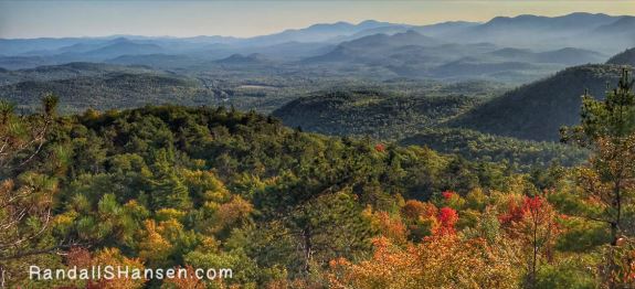
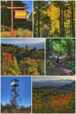
We again started our adventures with a chance to hike to the top of a local mountain — Poke-O-Moonshine — to see the amazing Autumn views from the summit — as well as that of an old fire tower. (The name comes from early settlers pronunciation of the Algonquin name for the peak, Pohqui Moosie, meaning “Broken and Smooth,” which most likely refers to the smooth summit rocks and the large broken slabs on its southeast side.)
Located along U.S. 9 in Lewis, there are two options for hiking up to the fire tower, a shorter and much more strenuous vertical trail (2.7 miles RT) or a longer (6-mile RT) and strenuous (but not so vertical) trail… We ended up doing the longer trail from the “main” trailhead; the shorter trail is accessed via the campground north of the main trailhead parking lot. You climb about 1,700 feet in elevation to reach the summit!
The hike is LONG and ROCKY and teases you with views until you finally reach an outcrop near the old fire tower tender’s cabin remains… at about mile 2.67. The views from that rocky ledge are wonderful, but push yourself for the last bit to the fire tower for broader and more spectacular vistas. (See the collage — and the cover photo for this blog post.) The hike was long, but worth it in the end. Plan enough time; we almost didn’t, hiking the last bit of the trail back to our truck in dusk conditions.

Because our campground was located about a mile down the road from a local orchard, we had to go visit it and take a walk through the apple trees.
Rulfs Orchard is quite impressive, with a farm store that of course sells bulk apples (including Macintosh, Empire, Cortland, Macoun, Northern Spy, Red Delicious, Golden Delicious, and Honeycrisp) and apple cider, but also includes a bakery and cafe, as well as a store with all sorts of goodies (including fresh produce, flowers, maple syrup, honey, jams, salsas, and more).
The store is open year-round… and the farm offers u-pick opportunities for berries (strawberries and blueberries) in the summer and apples in the fall. They also sell pumpkins in the fall and Christmas trees and wreathes in the winter. You can purchase plants and shrubs from their seven greenhouses during the spring… and wander through a corn maze in the fall months.
We walked along the loaded apple trees in the orchard, admiring the Macintosh apples and also enjoyed browsing all the goodies in the store. (Sadly, just about all the products were made with sugar, so we did not purchase anything.)
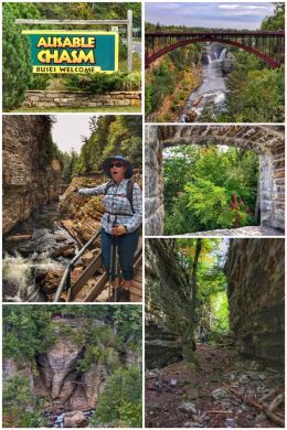
The next day, we had to play tourists and visit Ausable Chasm — a two-mile long sandstone gorge located near Keeseville, and just a few miles from our campground in Peru. Nicknamed the Grand Canyon of the Adirondacks, the Ausable River runs through the uniquely carved, vertically-walled gorge made of 500-million year-old rock and empties into Lake Champlain. Amazingly, it has been a tourist attraction since 1870!
Multiple options abound for spending your money here, but we opted for the “Classic Tour,” which includes access to all the park’s hiking trails above and near the gorge along with a raft tour through the gorge.
We started with hiking the Inner Sanctum Trail, a one-mile hike that includes natural stone walkways and a network of bridges and staircases leading down to the float tour area. Along the way, there are some wonderful vistas of the gorge and river, including Rainbow Falls, Column Rock, Hyde’s Cave, and Mystic Gorge.
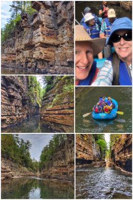
Next up was exploring the gorge at river-level. Once we strapped on our life vests and listened to the rules, we loaded up onto one of the rafts; happily we got to sit in the front of the raft. The raft takes you through the narrowest and deepest region of Ausable Chasm. Our guide navigated the raft between the towering cliffs of the Grand Flume, past the Broken Needle, and around the Whirlpool Basin… while discussing the geology and history of the chasm. The rapids, found mid-way through the float tour, are mostly fun and spun us around in the raft. We lucked out with our guide, who was a full-time employee of Ausable Chasm and talked about how different it looked in the winter. Note that the raft tour is fairly short, but still fun.
After the raft trip, people have a choice of grabbing a bus back to the welcome center or hiking one or more trails back to the parking lot. We decided to do a combination of the 2-mile Rim Trail along with a hike to one of the smaller dry chasms, along the 1.5-mile Dry Chasm Trail. (Note: The Rim Trail is fairly flat and the easiest hiking trail in the park.)
Back at the welcome center, we picked up a magnet and headed down one more trail … down to the Rainbow Falls/Elephant’s Head Vista. Elephant’s Head is supposedly one of the most photographed features of the park.
There are plenty of other trails to hike in the Lake Champlain area, but we had maxed out our time in the area. We also briefly considered a trip to Lake Placid, but work took precedence.
After the Adirondacks? We travel to Vermont — including one day when we rode the ferries across Lake Champlain to Burlington… onward through New England in the Fall!