
The last stops on our 2.5-year road trip are a mix of overnight layovers and 2-night stopovers, as we strategically make our way during the Covid Crisis from Virginia’s Blue Ridge Mountains to Eastern Washington, just north of Spokane.
It has been a bizarre and crazy drive — with campgrounds in certain states completely shut down and/or almost refusing us a night’s stay… while other campgrounds are not only wide open, but so are their facilities. This virus — and the frenzy around it — has made a lot of folks a bit crazy… when what we should be doing is focusing on how WE can ALL be more healthy — by washing our hands and practicing good hygiene, by eating better food, by exercising, and staying mentally fit… and by being responsible and staying home if we are compromised in any way (for ourselves and for the health of others).
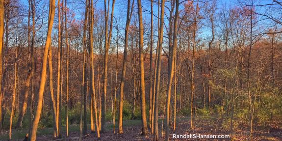
In West Virginia, we had to scramble to find a place — and happily, we were able to convince a sweet owner to let us stay the night… in the completely empty campground. The campground was located in the mountains and we had a great golden hour hike up to the top of the mountain.

Even with our daily travels, if the weather permits, we find places (still open) to hike in nature — one of the keys to staying healthy. When we had a brief stop in Kentucky, we crossed over to Ohio to hike in the Lake Vesuvius Recreation Area, located in the Wayne National Forest.
We decided to hike part of the 7.7-mile (RT) Lakeshore Trail, starting near the dam and traveling counterclockwise. The hike around the lake offers some wonderful encounters of crazy out-cropping cliffs and what appear to be boulders that were once under the water. It is a beautiful hike.
The 143-acre lake resulted from a dam built on Storms Creek by the Civilian Conservations Corps — and is named in honor of the Vesuvius Iron Furnace. The historic iron furnace, one of 46 charcoal iron furnaces located in the six-county Hanging Rock Iron Region of southern Ohio that produced iron for about a century (from 1818 to 1916). Fun fact: the Vesuvius Furnace produced 10 tons of iron each day until its final blast in 1906. Interestingly, these furnaces also played a key role in the Underground Railroad, providing safe houses and money for the movement of slaves seeking freedom. (The secret routes that the runaway slaves followed are the same roads as southern Ohio’s iron furnaces.)
From Kentucky, we traveled through Ohio and into Indiana, traveling for a few hours and spending a night in RV parks before moving onward.
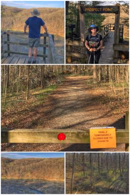
We were somewhat fortunate to have a lovely day to attempt some hiking in Indiana’s Shades State Park, a 3,082-acre located near Crawfordsville and about an hour from Indianapolis.
From the park’s description: “The beautiful sandstone cliffs overlooking Sugar Creek and numerous shady ravines provide the backdrop for your journey through this nature lover’s paradise. Also on the property is Pine Hills Nature Preserve, which affords spectacular topography for those willing to take a fairly long hike.” Sadly, much of the access to these locations in the park were closed. We still do NOT understand the closing of trails — popular or not — because of this virus… by closing most of the trails, it then forces people to all hike the one or two trails left open.
We ended up combining a few odds and ends of Trails 1, 6, and 9 — for about 2.3 miles of hiking — happily ending with an overlook above Sugar Creek called Prospect Point. Fun Fact: the area was originally known as the “Shades of Death.” Turkey Run State Park is located only about 5 miles southwest and offers similar terrain and hiking experiences.
We then traveled through Illinois, stopping for a night near Bloomington, before moving on to a multiple night stay in Davenport, Iowa… which almost did not happen because of the virus. Even though we had been in regular communication with the RV park and told what to do when we arrived, we were accosted shortly after we arrived by a woman in full gear (scrubs, mask, gloves) demanding to know what we were doing — as the park was no longer taking overnight guests because the state had “shut down all campgrounds.” Even though we finally convinced the woman — we guessed one of the managers, though she never did tell us who she was — to let us stay the two nights so we could get our tires rotated on the truck, her words sent us into a panic because we had planned to spend a few nights traveling through the state. After an hour or so of route planning and calling campgrounds, we happily found two more that WERE accepting overnight RVers and we could relax for a few days. Yikes.
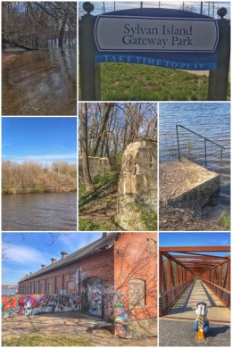
After all that stress, we needed a little break in nature — and found it back across the Mississippi River in a neat little park in Moline, Illinois: Sylvan Island Gateway Park. We loved the park sign (especially in these times) which says “Take time to play.”
The park sits along the Great River Trail, a 60-mile rail-trail that follows the path of the Mississippi River in Central and Northern Illinois, from Rock Island to Savanna. FYI: The trail is mostly a paved separated trail but also has segments of bike lanes on the street and a short stretch of road shoulder along Interstate 84. In some places, the paved trail follows the former spur route of the Chicago, St. Paul, Milwaukee and Pacific Railroad.
Sylvan Island Gateway Park has a small parking area, with a fairly new bridge that crosses from the mainland to the island. And amazingly, the park was completely open. The man-made 37-acre island (it had once been a peninsula) has a fascinating history — and the walking trails very easily navigated. We hiked most of the Shore Trail (though parts were under water from the flooded Mississippi River) and the Levee Trail, with a bit of the Forest Trail mixed in — for a total of about 1.5 miles. The island also has tons of crisscrossing mountain biking trails. We enjoyed seeing a snake on the trail and an otter just off the banks in the river!
Amazingly, the island once had apartment buildings, railroad tracks, quarry, and a steel plant (first the site of Sylvan Steel Company; later, Republic Iron and Steel Company). The first steel plant opened in 1894; the last closed in 1956. Two hydropower dams, located on the northwest and southeast tips of the island, are still in operation. Efforts began in the early 1990s to transform the island back to what it had been — and open it up as a park.
We hit another Costco Wholesale (Store #1325) while in Davenport — getting our free tire rotation, as well as purchasing gas ($1.14 a gallon!) and some grocery items (including our beloved macadamia and pistachio nuts).

We then did a quick overnight in Newton, Iowa, before traveling to Shelby, on the west side of the state, not far from Nebraska. Looking to get some good hiking in while we had some nice (but very cold) weather, we happily found Fontenelle Forest, which includes multiple trails that wander through forest, loess hills, prairie, and wetlands along the Missouri River. (Fun fact: loess hills were created by wind-blown silt deposits — some 200-feet deep –during glacial periods more than 10,000 years ago; they are found in the westernmost parts of Iowa and Missouri, and the easternmost parts of Nebraska and Kansas, along the Missouri River.)
This 1,400-acre forest is part of about 2,100 acres owned by a non-profit organization whose mission is to “provide a place where people can experience and enjoy the quiet wild of nature. We want to inspire current and future generations to care for the natural world.”
Fontenelle Forest, a National Natural Landmark located in Bellevue (a southern suburb of Omaha), has more than 26 miles of hiking trails — most of them fairly short — so we cobbled together our own 5-mile hike (and partial loop), starting at the closed nature center. Our hike began on the Riverview Boardwalk Trail, which is an extensive series of raised boardwalks that eventually lead to some views of the Missouri River. From there, we hiked down onto the Hickory Trail to the Upland North Area (loess hills) section, hiking the Chickadee Trail to the Hawthorne Trail and then onward to the Oak Trail and down into the spooky Handsome Hollow Trail… crossing the railroad tracks to the Floodplain North section, hiking parts of the Cottonwood Trail, Walking Club Trail, and Missouri Trail… before crossing the railroad tracks and reconnecting with the Hawthorn Trail and eventually getting back to the nature center.
While all the facilities remained closed, we were very grateful for the management’s decision in keeping the trails open for hikers. Because it is a non-profit, the entrance fees are a bit steep, but locals can buy an annual membership that has several other benefits beyond just trail access.
From Shelby, we traveled to our current “hometown” of Sioux Falls — the location from which this whole adventure started. South Dakota is one of a handful of states that allow people to be residents of the state with minimal time actually spent living in the state. In fact, about three years ago, we were in Sioux Falls for just one night (the residency requirement), obtaining our new driver licenses and vehicle tags and registrations.
We were amazed at how different the city looks in early spring versus the late summer. In fact, there was still snow on the ground from a recent late-spring snowstorm — and daily high temperatures of only the 40s.
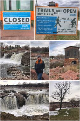
Falls Park is partially open, so we were happy we could walk the trails and see the falls. Sadly, the tower is closed indefinitely. The 123-acre park also connects to the city’s Big Sioux River Recreation Trail and Greenway, which forms a loop of nearly 30 miles of paved, multi-use pathways that link many of the city’s parks and green spaces — and runs partly along the Big Sioux River, which encircles the city. (Fun fact: The 419-mile long Big Sioux River is a tributary of the Missouri River, and runs through eastern South Dakota and northwestern Iowa.)
The Falls on the Big Sioux River is definitely something to experience — with an average of 7,400 gallons of water dropping over the course of the falls every second. The falls have been a part of recreation and industry since the founding of the city in 1856.
While in Sioux Falls, we also discovered yet another Costco Wholesale (store #1159), where we purchased gas, wine, coffee, and our wonderful Australian loin lamb chops. We also shopped at a nice little natural food market — The Co-op Natural Foods — picking up some ingredients for an organic bone-broth chicken soup dinner Ran has planned.
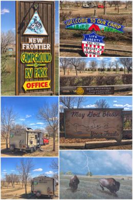
We then made a quick overnight stop in the middle of South Dakota in Presho… to a wonderful little campground in the heart of the prairie named New Frontier RV Park, a Good Sam Club park. (By joining the other 2 million or so members, you can enjoy 10 percent savings in a network of 2,400+ RV parks and campgrounds in the United States and Canada. We are Lifetime Members.)
There’s not much to see in the town of about 500 people, but it’s a nice walk from the campground — and everyone waves at you as you walk down the street! And while we did not have much time to explore, the campground says this area is known for its scenic beauty, abundant hunting, and outdoor activities. Scenic beauty for sure!
Did we mention we had the whole campground to ourselves? Thank goodness for campgrounds that stay open even when business is almost nonexistent… it was truly a perfect overnight stop for us!
From there, we returned for the third time to Rapid City, which is located on the eastern slopes of the Black Hills — and one of our favorite places in the U.S. There’s something about driving for hundreds of miles through prairie and then hitting this beautiful mountain range. Rapid City, named for Rapid Creek (near which the town developed) is the second-most populous city in South Dakota.

Rapid City is the perfect place to anchor a trip to the Black Hills — which offers not only brilliant natural beauty, but also historic elements (such as Mount Rushmore National Memorial and the Crazy Horse Memorial) and other national areas of significance — including forests, monuments, and parks.
As soon as we had set up the camper in the RV park, we jumped in the truck and headed for a new adventure for us… a hike in the Black Hills National Forest on a trail referred to as Buzzards Roost; the trailhead is about eight miles west of the city. We used AllTrails, which showed a 2.2-mile loop, but it is actually a system of trails that feature more than eight miles of diverse trail options. AllTrails also lists this hike as “easy,” but with a 500-foot elevation gain and some crazy rock scrambling, we would definitely say this hike is moderate.
We rejoiced in seeing our Ponderosa Pines once again, as well as some of the breathtaking views. At the top, we said a prayer of thanks to God for creating this amazing planet, as well as for giving us the ability and health to hike.
We have only scratched the surface of the Black Hills National Forest — a 1.25 MILLION acre forest that spreads from southwestern South Dakota into northeastern Wyoming; it is approximately 110 miles long and 70 miles wide. It was established by President Grover Cleveland in 1897. While the national forest is packed with Ponderosa Pines, it also has a few other trees, such as Aspen, Bur Oak, and Birch. The forest also contains the tallest mountain in Soth Dakota and the highest peaks east of the Rocky Mountains in Black Elk Peak (7,242 feet in elevation). For those who prefer driving over hiking, there are TWO scenic byways in the national forest. (For those who do like hiking, there are more than 450 miles of trails in the forest!)
We have mentioned it in a previous blog post, but while in this area, you must also visit Badlands National Park, Wind Cave National Park, Jewel Cave National Monument, Devils Tower National Monument, and Custer State Park. There are lots of touristy type stuff too — like miniature golf, reptile and dinosaur adventures, and more.
The Black Hills are also a rock and mineral lovers dream — one of the top places in the country for rockhounds. In addition to agate and rose quartz, there are more than 140 other minerals found here: including copper, silver, lead, tin, feldspar, spodumene, beryl, mica, quartz, and gold. The Homestake Mine in Lead was the largest and deepest gold mine in North America until it closed in 2002. The Black Hills themselves are mostly granite. Fun fact: Rose Quartz was named the official mineral of South Dakota in 1966.

We ended our two-day stay in the area by supporting a local business — something we all need to be doing now if we can. We believe this was our fourth trip to Praire Berry Winery, located near Hill City (about 24 miles south of Rapid City).
We discovered the winery on our first visit to the Black Hills when we purchased our travel trailer from the nice folks at Green Star Camper Center. Our first campground was just down the road from the winery and we fell in love with the winery’s sense of humor — and tasty wines. (We liked our first tasting so much, we came back the next day for seconds!)
We visited the winery again two years ago when we visited the Black Hills as part of this adventure… and had another nice tasting, but we left a bit bummed because one of favorite varietals, Frontenac, was sold out.
This time, of course, the winery was closed to tastings because of the virus… but we happily discovered that they were allowing pick up at the winery (with either an online or in-store purchase) AND that a new vintage of the Frontenac was available. As we have all along on this trip — but especially in these current conditions — we wanted to support local businesses, so we took a wonderful drive down to the winery (shortly after a late-spring snowfall) to buy a half-case that also included something new to us — Buffaloberry Fusion.

From these wonderful Black Hills, we continued heading northwest into Montana, where we had a quick overnight — and a campground all to ourselves again — in Broadus, at the Wayside RV Park. Broadus is another small town (of about 500 people) and if you blink, you might miss the town from the highway.
Happily for us, the owner of the RV park had a little farm and we took great joy strolling the property and talking with the horses, sheep (and lambs!), chickens, geese, and turkeys.
Right next door to the RV park is the Broadus golf course, which also provided a nice stroll, with some pretty views — and a very short glimpse of an otter!
Overall, it was a wonderful stay — except for all the wind!
From Broadus, we traveled to Billings, the largest city in Montana. Here, we planned to do some hiking near the Yellowstone River and catch one more Costco Wholesale (Store #69!) and Natural Grocers before making our final push toward our property. Plans changed, though, when the power steering unit on our truck had a momentary freakout and we decided we had better get it checked out as soon as we arrived in Billings. We went to Denny Menholt Chevrolet and they spent more than an hour analyzing the truck and giving it the ok… before sending us on our way — at no charge, and with a coupon for a free car wash! Happily, the Costco and Natural Grocers were both located within a mile or so of the dealership — so we got all our errands done in one afternoon.

Unfortunately — or, rather, fortunately — we discovered a problem with a tire on the travel trailer (in the same location of the one that blew earlier this year)… so we spent part of the next day switching out the new spare tire with the bad tire… which should help us get the rest of the way back to Northeast Washington. (We have Good Sam Roadside Assistance and a service tech came and did the tire switch for no cost to us.)
In between all these issues, we did get a chance to get out in nature — both high above the Yellowstone River and along the banks of the river. The 690-mile long river is another tributary of the Missouri River — and was explored by William Clark on the return voyage when Lewis and Clark took separate routes for a time. Fun fact: Clark’s Fork of the river was named for William Clark.
Our KOA campground is situated along the banks of the river, so we walked the river several times over the two days we were in town… but we were more excited to get a birdseye view of the river by hiking about 2.25 miles on a few trails in the Four Dances Recreation Area, a 765-acre undeveloped open space that consists of native sagebrush/grassland and Ponderosa Pine in the rocky outcrop areas near the river cliffs. It sits on a plateau edged with cliffs that drop 200-500 feet to the river. Happily, the land was saved thanks to the Yellowstone River Parks Association and the U.S. Bureau of Land Management (BLM).
Fun fact about Billings: it was founded in 1882 and named for the president of the Northern Pacific Railroad, Frederick Billings. After the railroad established the city, it quickly grew and got nicknamed the Magic City because it seemed to almost appear overnight — like magic.
Crazy geological facts: The Yellowstone Valley where Billings is located is a canyon carved out by the Yellowstone River… but back 80 million years ago the Billings area was on the shore of the Western Interior Seaway. (Yes! Another ancient sea.) The sand and sediment eventually formed into Eagle Sandstone and during the last million years or so, the river carved its way through the stone to form the canyon walls that are known as Billings Rimrocks.
We then drove to Bozeman, founded in 1864, and the fourth largest city in the state. We had not originally planned to stay here, but with the virus closing campgrounds across the state, Bozeman became a place to stop because it had an open campground — one that even had open laundry AND bathrooms… and, cooly, the campground was located near the Bozeman Trail. Interestingly, the city is named for the man who established the trail — John M. Bozeman. The Bozeman Trail, mainly used in the mid-1800s,
was an overland route connecting the gold rush territory of Montana to the Oregon Trail (a 2,170-mile east-west, wagon route and emigrant trail that connected the midwest to valleys in Oregon).
One other great thing about Bozeman… We unexpectedly — and happily — we found another Costco Wholesale (Store #96). This time, we only stopped for gas.
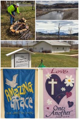
We then traveled to Garrison, Montana, stopping overnight at a quite wonderful RV park: Bernie & Sharon’s Riverfront RV Park, which is situated on 20 acres along the Little Blackfoot River (a 48-mile long tributary of the Clark Fork River).
Garrison only has a population of about 100 people, but it does have a post office and a handful of other stores. (We had to go to nearby Deer Lodge to buy gas!)
The RV park is small and quiet, with only about 50 sites in the whole park. Interestingly, it is a completely rehabilitated old trailer park that was filled with rundown mobile homes when Bernie and Sharon purchased it in 1991. The folks here are wonderful and we were treated to some free firewood to have a lovely campfire.
Our favorite part about the park is God’s influence… from the owner’s belief that the park was God’s gift to them to share with others to the amazing nondenominational chapel the couple built in the park. In normal times, there is a Sunday morning worship service.
From Garrison, we made one last stop in St. Regis, Montana, which typically has two Good Sam RV parks open… this time only one was open, but that was enough for us. The best part about St. Regis is the neat little store located at the Sinclair Gas station… because it sells huckleberry wines and vodkas. We have missed those huckleberries!

Our final stop is a brief stay at Shore Acres Resort, a crazy and cute little campground (with cottages) located along the banks of Loon Lake. We are staying here for about 10 days while we get our H3 situated with a spot to park the trailer for the rest of the summer during which we will be building our house.
The collage just shows a few of the sites on our property — from our first hike onto it in two years! We loved seeing the serviceberry blooming, but were especially pleased to find several patches of very happy arrowleaf balsamroots blooming. We have a LOT of work to do with the forest, let alone in dealing with all the construction preparation, but we are looking forward to it.
By the way, we also have reintroduced ourselves to our local Costco Wholesale location, store #1298, located in north Spokane.
After 2.5 years and tens of thousands of miles on the road throughout the U.S. and parts of Canada, we are ready for this new adventure… and really ready to be done pulling our trailer and worrying about the axles and tires.
We loved sharing our pictures, stories, and advice with you about all the parks we have visited and trails we have hiked or biked. We plan to do something with all the pictures, but we have not yet decided… perhaps calendars, perhaps a book.
We will be back on the road again — both throughout the Pacific Northwest (the PNW) — but also to Alaska and Hawaii… and also Europe… so the adventures both near and far will continue for sure!