
Per our usual travels, we crisscrossed through Kentucky — state #47, the second-to-last state in our quest to visit all 48 continental states on this part of the adventures — starting in Paducah, located in the southwestern part of the state, at the confluence of the Tennessee and the Ohio rivers.
It’s amazing to think as we entered Kentucky, no one in the U.S. was even talking about the coronavirus… and toilet paper, ground beef, and other supplies were not being hoarded.
We stayed at a KOA campground just outside Paducah that is small, quiet, and was perfect for us. The campground has fairly new owners and they are investing in upgrades — including excellent Wifi. Plus, they are just very nice people.
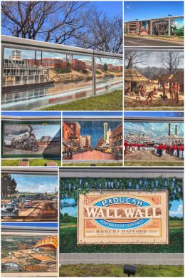
Paducah has an interesting history, starting as a major hub for both river and rail transportation.
A massive and historic flood in 1937 impacted the town — with the Ohio River cresting at 60 feet above its flood level in early February, forcing the evacuation of the entire city for weeks. An earthen levee provided no protection, so afterward the U.S. Army Corps of Engineers constructed a massive floodwall system to protect the city. In the late 1990s, a mural project was started on a several-block section within the historic section of Paducah to paint the floodwall panels with scenes depicting the history of the town. The renowned Dafford Muralists capture all aspects of the city’s history — and are lit up at night for viewing 24/7.
Paducah is also famous for being an Atomic City. Back in 1950, the U.S. Atomic Energy Commission selected a site near the city for a new uranium enrichment plant; it opened in 1952 and was shut down in 2013. The Paducah Gaseous Diffusion Plant (PGDP) produced low-enriched uranium, originally as feedstock for military reactors and weapons… and later for nuclear power fuel. The PGDP is owned by the Department of Energy, which oversees environmental cleanup activities at the site, including environmental remediation, waste management, depleted uranium conversion, and decontamination and decommissioning.

We crossed town to Noble Park so that we could walk some of the Clyde F. Boyles Greenway Trail. We ended up hiking about 3.4 miles of the 5-mile trail. The part of the trail we hiked is mostly forested and follows part of Perkins Creek; it also passes the old Bluegrass Downs, which is currently closed. The former harness racing track (though it was originally constructed for quarter horse racing, then converted in 1984 to thoroughbred racing) has many rundown paddocks, which makes for an interesting diversion. The trail is also a first for us in seeing signs stating that the trails are smoke and vape free; kudos to the city of Paducah!
Noble Park is the perfect spot to start the trail because you can hike to the west (along a mostly gravel trail) all the way to Perkins Creek Nature Preserve (Mile 0.0) or to the west on a concrete path sitting on top of the old earthen levee to the Ohio riverfront area (Mile 5.0). Whichever way you choose to go, the trailhead is located on the western edge of Noble Park, right next to the basketball courts and skatepark. The city currently has plans to extend the trail into the undeveloped nature preserve (for about another mile) and along the riverfront and Schultz Park.
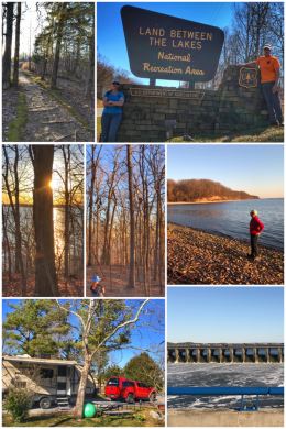
Paducah is also a fantastic area to camp if you are interested in adventuring in the Land Between the Lakes (LBL) National Recreation Area.
On the west side, Kentucky Dam (shown in the collage), which was built by the Tennessee Valley Authority and used for hydroelectricity and flood control on the Tennessee River, impounds the 160,000-acre Kentucky Lake — the largest artificial lake by area in the Eastern United States. A 1.75-mile canal connects Kentucky Lake with the 58,000-acre Lake Barkley, to the east, which was created by the Barkley Dam on the Cumberland River (constructed by the U.S. Army Corps of Engineers in 1966)… with the Land Between the Lakes National Recreation Area sitting between the lakes. (Both the lake and the dam are named for Kentucky native and former U.S. Vice President Alben Barkley, who served under President Harry S. Truman.)
The land was designated as a national recreation area in 1963 by President John F. Kennedy, but it was not until 1998 when Congress authorized the transfer of operation of the area to the U.S. Forest Service. The area is unique for several reasons. First, the land is where several communities once existed before Kentucky Lake was developed. Second, the recreation area contains several special features, including: a 700-acre Elk & Bison Prairie, Woodlands Nature Station (a rescued animal sanctuary), The Homeplace (an 1850-style farm), and Golden Pond Planetarium. (Note: All the special features require additional fees.) The recreation area also has
444 miles of scenic roads, hundreds of miles of trails and abandoned roads (for hiking, biking, and horseback riding), 25 boat ramps, an off-road vehicle area, and several campgrounds (some with full hookups), group lodges, and a few cabins. It also includes more than 300 miles of undeveloped shoreline and 170,000 acres of forests and open lands. The recreation area spans both Kentucky (mostly) and Tennessee.
We started our exploring at the North Visitor Center, which is also the trailhead for the Canal Loop Trail. The visitor center is small, but does have maps and some supplies and souvenirs. The Canal Loop Trail is a 10-mile loop, but with several offshoots that allow hikers to create a shorter loop. For example, we did a 2-mile loop, which included some nice views of Kentucky Lake.
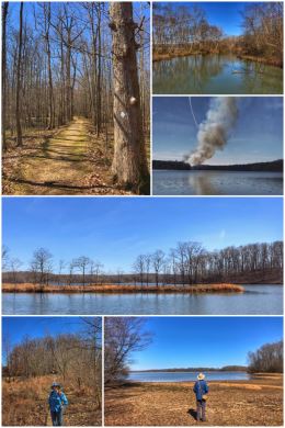
The next day, we decided to tackle the Honker Trail, a 4.5-mile loop trail that starts at the Woodlands Nature Center. The trail is named for the Canada Geese that call the area home. (We did see one couple of geese along the trail.) The hike is moderate, with some ups and downs, and goes through a variety of habitats, including forests, meadows, and lakes (including Honker Lake and views of Lake Barkley). We also got to watch a prescribed burn taking place across the lake.
By the way, because it is a recreation area, licensed hunts for deer, turkey, squirrel, and other small game animals occur throughout the year. Fishing is also very popular here.
We did not have the time, but there are also four state parks and a national wildlife refuge that surround the LBL in what is referred to as Kentucky’s Great Lakes Region: Kentucky Dam Village State Park, Mineral Mound State Park, Lake Barkley State Resort Park, Kenlake State Park, and Kentucky Woodlands National Wildlife Refuge.
Mammoth Cave National Park
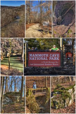
We then traveled to Cave City, staying at a campground just a few miles from Mammoth Cave National Park — arriving (unknowingly and thankfully) about 10 days before the park would cancel cave tours because of the ongoing concerns over Covid-19. The park is named for the large width and length of the passages connecting to the Rotunda just inside the entrance — and not to its overall size (unknown at the time) or to woolly mammoths.
Mammoth Cave National Park is the 46th national park we have visited — in our 47th state — on this 2.5-year adventure. The park protects the largest cave system in the world, with more than 400 miles of surveyed passageways — and they are not even close to finding the end of the system! The park also protects part of the Green River, as well as 52,830 forested acres above the cave system. It became a national park in 1941, a World Heritage Site in 1981, and an international Biosphere Reserve in 1990. (An interesting side note: concerned citizens formed the Mammoth Cave National Park Association in 1924, but it took almost two decades — with thousands of people forcibly relocated in the process — for the land acquisition to reach the required 45,310 acres to officially create Mammoth Cave National Park.)
Above the ground, the park has nearly 70 miles of surface trails (for hiking and biking), 13 backcountry campsites, three campgrounds, and more than 20 miles of navigable river. Our goal on the first day of our visit was to explore above ground — hiking the 1.3-mile Green River Bluff Trail (with the trailhead located at the picnic area to the north of the visitor center), which includes an overlook (of the Green River), as well as connections to the old riverboat landing site, Dixon Cave, and the River Styx Spring. Another fun fact: the Green River (and its tributary streams) is the central force in the creation/carving of the caves/cave system. We ended up hiking a rather large loop back to the visitor center, for a total of 2.8-miles.
The limestone here is a major part of the caves — and is thought to have been formed from sediments deposited on the floor of a warm, shallow sea (the Mississippian Sea) some 350 million years ago. The tops of the caves are protected by layers of sandstone caprock. We have heard so many stories of much of the parts of the country we have visited that were once covered by shallow seas or ancient lakes. Amazing.
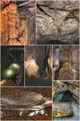
The next day, we returned to the visitor center for a cave tour, followed by exploring the exhibits of the visitor center — and purchasing a magnet. We had purchased our cave tour in advance, which is a wise strategy once the tours restart. Multiple tours are offered, and one park ranger suggested taking several tours over a few days to truly experience the cave’s features… fees are charged for each tour, and many tours are limited to just a few per day.
We chose the River Styx Tour — which follows the Historic Tour route, but focuses on the unique geologic and natural history of Mammoth Cave. Including a brief side trip to the underground water level of the River Styx, this tour takes an in-depth look at the millions of years of formation of Mammoth Cave — and takes about 2+ hours, walking about 2.5 miles, and navigating about 600 stairs. We loved wandering in the cave — including crazy parts like Fat Man’s Misery, a very narrow passageway that takes some talent to navigate — but found the ranger leading the tour somewhat lacking knowledge/expertise.
The other fascinating part of Mammoth Cave is that it has several creatures that have completely adapted to the darkness of the cave — including the Kentucky Cave Shrimp (blind, and found only in Mammoth), the eyeless Cave Fish, and the Cave Crayfish. Many species of bats also hibernate in Mammoth Cave, but sadly their numbers have dwindled from the millions to the thousands… partly because of a fungal disease called White-Nose Syndrome (WNS), which has infected many caves throughout the United States (and sometimes transmitted from one cave system to another by people).
Carey & Mike’s Ranch
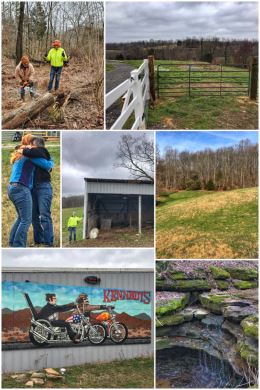
We then traveled a short distance to visit with some dear friends — something that had been circled on the calendar since the start of this journey!
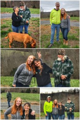
Mike and Carey moved from California to follow their dream of owning a large ranch — and they found it in southwestern Kentucky. Carey and Jenny are long-time friends who consider each other soul-sisters… and ever since Carey and Mike moved to their new property, Carey has had a long to-do list… and we were excited to help her cross some of those projects off her list — including fixing some fencing, installing a new gate, adding a gutter for rain-catching, and teaching Carey how to use a chainsaw.
Carey and Mike have lots of animals — including sheep, cows, chickens, and pigs. (They also have a horse and two dogs.) She has plans to have a working farm, selling pastured meats and eggs. They also have opened a motorcycle shop, doing repairs and selling parts. They have a lot of acreage and it was fun exploring different parts of it — including pastures, creeks, springs, and a waterfall. Mike also says there are at least two small caves on the property as well.
It was hard work — and hampered by bad weather — but so satisfying helping them both in building their dream.
On the last day of the visit, we had to have some fun and take some group pictures.
By the way, here are some fun facts about Kentucky: It became a state on
June 1, 1792. Known as the Bluegrass State, the origin of the state’s name comes from an Iroquoian word “Ken-tah-ten” meaning land of tomorrow. The state bird is the Cardinal and the state tree is the Tulip poplar. Kentucky’s northern border is formed by the Ohio River and its western border by the Mississippi River.
Besides Mammoth Cave and the massive reservoirs, Kentucky is also known for its bourbon (a corn-derived whiskey) as well as the Kentucky Derby and racehorses. Its capital is Frankfort and its two largest cities are Louisville and Lexington — both of which we will visit as part of our travels through the state. While we were in Kentucky, the Derby was canceled because of this health scare and rescheduled for September.
More Pastured, Grass-Fed Beef
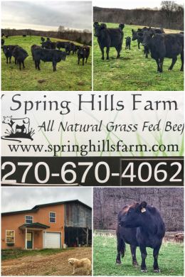
The state also has a lot of cattle ranchers, and we were lucky to visit one — and buy some wonderful natural, grass-fed, pastured beef from Spring Hills Farm, located just outside of Glasgow.
Like many other ranches along this trip, we found Spring Hills Farms from EatWild.com. We contacted owner Roland Hoffman and he graciously invited us to the ranch to talk cattle, visit cattle, and buy some beef. His cattle — Black Angus — are born and raised naturally (meaning no hormones, steroids, or antibiotics) on the farm — rotating from one pasture to another to ensure the highest quality forage possible… and never any grain. “Our animals are raised on pasture as God originally intended them to live.”
Spring Hills Farm is named for the many springs found on the property. Roland and his wife bought the property more than 20 years ago. (It was an old, Amish farm at the time.) They were originally focused on milk production — from both goats and cows. They also had chickens and sold eggs at one point. Today, it is all about the beef — and rotating his cattle among several large paddocks on his 100-acre ranch.
We bought several filet mignons (some of which we have already grilled), several strip steaks, a sirloin steak, and several packages of ground beef. Have we mentioned how much we love supporting local ranchers — and after seeing all the bare meat sections in supermarkets because people went crazy hoarding crappy grain-fed, feedlot meats — we cherish our quality meat even more.
We then continued the travels in Kentucky with a short stop in Mount Vernon, in the Renfro Valley. Our campground was located just up the road from the Kentucky Music Hall of Fame & Museum. This stop was uneventful except that it was here that we decided to shorten our trip by two weeks because of all the panic and uproar over Covid-19 and head back to Washington State as state parks and campgrounds closed all or parts of their facilities.
While in the area, we did our usual thing — which everyone should be doing regardless of a virus or not — and that is walking/hiking in nature… and we found an amazing hike just a few miles north of our campground.
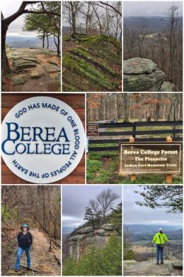
We decided to hike the Lower East Pinnacle Trail — part of the larger Indian Fort Mountain Trail at Berea College — which can be reached from the parking lot at the Berea College Forestry Outreach Center on Highway 21. Multiple trails exist — from easy to difficult — and all are fairly short (1-4 miles RT). We chose the Lower East Pinnacle Trail because of its distance and level of difficulty (easy-moderate)… and because of the views at the end of the trail — which are quite outstanding, even on a cloudy/overcast day. (We hear that really all the hikes in the Pinnacles have amazing views.) Our hike ended up being about 3.7 RT miles from the parking lot.
Fun facts: Berea College currently manages 8,000 acres of forest land. And about the town itself? Berea is a fast-growing tourist attraction, hosting several crafts festivals throughout the year, as well as other events. Berea College charges no tuition; the 1,600 or so students are awarded essentially a four-year scholarship. The college was founded by Protestant Christians — and it maintains a Christian identity today, but not tied to any denomination. Its motto caught our eye as we drove into the parking lot: “God has made of one blood all peoples of the Earth.” (Acts 17:26)
Next up was Sherpardsville, just south of Louisville. Our main goal for visiting the Lousiville area was to meet up with some friends, but once again the Covid-19 affected our plans. We did get to see one old friend who lives in Corydon, Indiana, just west of Lousiville — and that was a wonderful visit; the visit was made more special when we could bring a bunch of food a Canadian camper passed on to us as he and his wife were rushing back to Canada before the border closed. We had also planned to visit a long-time friend who works for Churchill Downs, but the racetrack was on lockdown … and she had a cold and we just could not find a time or place to meet — while keeping social distancing/isolation.
We did attempt a bit of shopping in Lousiville, stopping at Costco Wholesale Store #1238, where the store had posted a list of items still sold out. Sadly, we could not find our organic chicken or Australian lamb chops, but did pick up more nuts and other supplies… as well as fill up the tank at $1.659 a gallon!
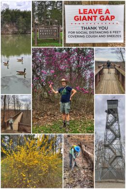
So, again, as we have done all along on this trip, we decided to find a place to hike in nature… and located just south of us was the Bernheim Arboretum and Research Forest, a truly special place. (Plus, we were just happy to find them still open for hiking!)
Signs were in full force for social distancing, though as some are suggesting, it really should be called physical distancing… keeping enough space between small groups. On most trails we hike, physical distancing is rarely an issue, but we decided to do the Forest Giants Trail, which was fairly crowded with families looking to spend time in nature — and bravo to them. Ran thought the trail name implied big trees, but instead the trail is designed more for kids and features giant wood sculptures. So… from there, we drove up to the Iron Ore Hill Loop and Canopy Tree Walk… and ended the hiking with the short .5-mile Fire Tower Loop. We happily ended the day with about 4.5 miles of hiking in the woods! (In case you were wondering, the fire tower was constructed in 1929 by the Kentucky Division of Forestry and is occasionally open to the public.)
Bernheim, which has more than 16,000 acres, has more than 35 miles of trails for hiking and biking — through knobs and valleys, along ridges and hollows. The 600-acre arboretum has more than 8,000 varieties of trees, shrubs, and herbaceous perennials… including a holly collection of more than 300 species of holly. To see the land today, you would not know that at one point the whole area had been stripped for mining iron ore. Fun fact: Frederick Law Olmsted (of New York’s Central Park fame) helped design the park in the 1930s; it opened to the public in 1950.
By the way, if you are wondering what Jen is doing in one of the pictures in the collage, she is partaking in one of her favorite activities on the trail — clearing leaves and debris from a stream to get the flow moving and reduce flooding on the trail.
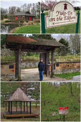
We then moved eastward from Louisville to Georgetown, just north of Lexington — our last stop in Kentucky. Georgetown (originally founded as Lebanon, but renamed in honor of President George Washington in 1790) has some beautiful older homes and is known for being a railroad hub — and more recently as home to Toyota Motor Manufacturing Kentucky, Inc. We stayed at a fairly quiet and nice RV park just off I-75, Whispering Hills. If you stay here, be sure to check out Ward Hall (a massive “summer home” mansion on the National Register of Historic Places) and the downtown Oxford Historic District (also on the National Register of Historic Places). We walked around Yuko-En on the Elkhorn, a 5.5-acre green space that celebrates the friendship between Kentucky and Japan; it features a Tokugawa gate, koi pond, and rock garden. Its mission is to enhance community, international friendship, and appreciation of nature.
We did some needed shopping in Lexington (including a local food co-op, Good Foods, and another Costco Wholesale, Store #1156, including gas at $1.499). Because we have limited space, we are pretty much shopping as usual and hoping to find — and usually successful at doing so — organic foods. Happily, this Costco had our organic chicken and lamb chops in stock!

We got our final outdoor fix closer to Frankfort, located west of Georgetown and Lexington, at Cove Spring Park. The 240-acre park includes wetlands, streams, springs, waterfalls, forested ravines, and other natural and historic features.
The park has about 3 miles of interconnected trails and we hiked about 2.6 miles of them! We hiked the Holly Trail to the Osage Trail (completing a large clockwise loop of the park). To add a bit more, we also hiked the Blackberry Meadow Trail. The trails were a bit muddy at points, but the vistas nice, with much of the understory greening up… and those creeks with the beautiful step waterfalls…. amazing. A few benches are sprinkled out along the trails.
Not surprisingly, there were lots of folks and families out and about in the park. The park also has shelters and picnic areas — and typically working bathrooms (though they are currently closed because of the crisis).
We truly loved the beauty of Kentucky’s rolling hills, springs, caves, and creeks… though we did miss the sun for most of the days we were in the state. Spring rains indeed! And we are quite sick of all the Covid-19 news and fears and hoarding of foods and supplies.
Next up we hit our 48th state on this 48-state road trip and make plans for turning around and heading back to Washington.