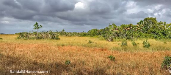
Imagine a vista of grass and water, with a few small tree islands sprinkled about the horizon, for as far as the eyes can see… filled with waterfowl like Anhingas and Egrets as well as alligators and turtles… and you have an idea of the everglades.
Florida has three national parks, and all are located in the southern part of the state. We began our exploration with the largest (and perhaps most important) in Everglades National Park. How large is it? It is so large that it has FOUR visitor centers (and all are open 365 days a year). How large is it? More than 1.5 million acres! How important is it? It protects the largest subtropical wilderness in the United States — salvaging the last 20 percent of the original everglades. How important is it? The everglades serve a vital role in cleaning and recharging South Florida’s freshwater… and it all starts near Orlando in Central Florida and the shallow Lake Okeechobee, the largest freshwater lake in the state (and the eighth largest in the U.S.) … with water emptying out of the lake and heading southward — forming a slow-moving river (a “River of Grass”) that is 60 miles wide and more than 100 miles long across a shallow limestone shelf with minimal elevation changes before reaching Florida Bay and the Gulf of Mexico. The very flat everglades is a mosaic of marshes, sawgrass prairies, and forest (islands).
We attempted to start our discovery of this massive park — #43 in our attempt to see all the U.S. national parks — at the Shark Valley Visitor Center, located about 40 miles due west of Miami. The main feature at this visitor center is a 2-hour narrated tram ride (fee-based by an outside concessionaire) through this section of the everglades. Unfortunately, December is one of the busiest months to visit — and when we arrived in the early afternoon, the parking area of the visitor center was full and a long line of vehicles waited ahead of us for entry… so we ditched that plan! If you do not want to do the tram, you can also hike or bike the 15-mile Shark Valley Tram Trail. (Bike rentals are also available if you don’t have yours with you.) About halfway along the trail, a 45-foot high observation tower provides a spectacular view of the sawgrass marsh in this section of the park. Key advice: Arrive as early as you can to nab a parking spot.
This area of the park sits along the Tamiami Trail — whose name is derived from its two endpoints, Tampa and Miami — the first road to cross the everglades. Its history is one filled with wealthy businessmen and a fair amount of controversy, but the road was finally completed in the mid-1920s. It was a feat of engineering, but it also involved dams and dikes — and led to the beginning of problems facing the everglades in blocking the flow of water from Lake Okeechobee. Today, the key part of the trail that cuts through Everglades National Park and Big Cypress National Preserve is named U.S. Highway 41.
The next day, we left a bit earlier and made tracks to the Ernest F. Coe Visitor Center, located about 10 miles southwest of Homestead and about 40 miles southwest of Miami. The visitor center honors the man some call the Father of Everglades National Park. Coe was a developer turned conservationist who saw the light and worked hard at trying to preserve more than 2 million acres of the everglades. Once again, we learned the power of one person to rally people to come together to protect a sensitive and important natural resource.
While at the visitor center, we watched the very enlightening film (which partly discussed all the national parks in the region) and picked up a magnet — as well as some hints for the best places to visit. (We also learned that almost all the trails in this section of the park are fairly short.)

While Everglades National Park was established in 1934, it has really been in the last several decades that more money and effort has been put into the restoration of the park — from damage caused by thousands of miles of flood-diversion canals built by the U.S. Army Corps of Engineers. (The everglades were dammed, diked, and drained prior to being preserved and slowly restored.)
We started our journey on the 38-mile road between the Coe Visitor Center and the Flamingo Visitor Center by stopping at Royal Palm — which pays tribute to Royal Palm State Park — established in 1916 — and which later became the nucleus for Everglades National Park, which acquired the state park in 1947. (This stop includes the Royal Palm Information Station, bookstore, and restrooms.) More importantly for us, it includes two interesting hiking trails. We decided to hike the Gumbo Limbo Trail first — a .4-mile paved loop trail that meanders through a shaded, jungle-like hammock of gumbo limbo trees (native to South Florida). We then hiked one of the top attractions in the park, the Anhinga Trail, a .8-mile (RT) paved and boardwalk trail that winds through Taylor Slough and the sawgrass prairie; it’s one of the most popular because of the high likelihood of close encounters with wildlife — and we saw plenty, including many anhingas and several alligators, along with fish and one massive turtle.
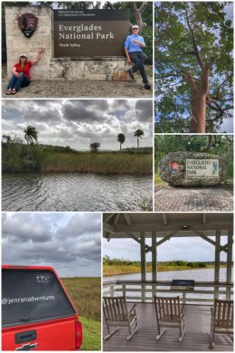
We also learned of a very important element in the Everglades — and shown in the upper right picture in the collage — periphyton, a soft, spongy mat of algae that floats along the surface and is grazed on by fish and tadpoles. In the winter (supposedly dry months), it serves as a haven for snail, crayfish, and insect larvae.
Speaking of “dry” winter months, it rained most of the days we visited this area — and were told once again of the changing weather patterns. It used to be the winter months were the dry season and summer the wet, rainy season. Not any more.

From Royal Palm, we continued on to pinelands area of the park, stopping to hike the .4-mile (loop) Pineland Trail, which wanders through a pine rockland habitat. The pinelands are the most diverse habitat in the everglades, consisting of an open South Florida slash pine forest with an understory of subtropical plants.
It was along this trail that we learned of the park’s beautiful Lignus tree snails, which sleep (a quasi-hibernation) during the dry season by climbing a tree and sealing themselves onto the trunk. The snails, of which there were once 52 color varieties, originated from the West Indies; sadly, collectors sometimes gathered the shells and burned the hammocks where they lived — to increase the value of the shells. We also learned that the 20,000 acres of Slash Pines in the park represents all that remains of what was once more than 200,000 acres that occupied the high ground of the Atlantic Coastal Ridge (which runs from Palm Beach, Fort Lauderdale, Miami, and Homestead deep into the Everglades).
We continued on to the Pa-hay-okee Overlook. Pa-hay-okee is Seminole for grassy waters — and this .16-mile boardwalk loop provides sweeping vistas of those grassy waters that populate the eight-mile wide Shark River Slough… along with a forest of bald cypress trees, which look a bit eery in winters when they lose their needles (as shown in the top two photos of the collage).

We were told that both the Pa-hay-okee Overlook and our next stop at the Mahogany Hammock Trail are good places to see crocodiles — though we did not on our hikes. In fact, the everglades is the only place in the U.S. where one can see both alligators and crocodiles!
The Mahogany Hammock Trail is a .5-mile (RT) boardwalk trail that meanders through a dense, jungle-like tropical hardwood hammock that includes gumbo-limbo trees, air plants, and the largest living mahogany tree in the United States — and that massive tree alone is worth the visit. This area is also popular with owls, and we did see one hidden in a tree, deep under the boardwalk. A natural moat surrounds the hammock, protecting the trees there from wildfires.
We concluded our adventures in Everglades National Park at the West Lake Trail, a once looping .5-mile boardwalk trail that travels through a forest of white mangrove, black mangrove, red mangrove, and buttonwood trees to the edge of West Lake. Today, the trail splits near the lake, but both sections end abruptly as the connecting piece of the boardwalk is now underwater (and shown in the bottom left photo in the collage). Mangrove trees are an essential part of the everglades and the coastal ecosystem — located in areas where freshwater and saltwater intermingle. Their roots hold deeply into the soil and help protect against erosion, while also serving as a habitat for young fish, reptiles, and amphibian species. The trees also provide nesting habitats for wading birds.
FYI: West Lake is one of the few spots along the stretch between the Flamingo and the Coe visitor centers that has restrooms, so plan accordingly. (The other is at Royal Palm.)
By the way, the fourth visitor center is the Gulf Coast Visitor Center, located in Everglades City — about 35 miles southeast of Naples. The visitor center is in a temporary building as the original one was destroyed by Hurricane Irma in September of 2017.
Next up? The next national park in the area… Biscayne National Park.