
As we closed in on our week-long visit to New Jersey and New York City, we decided to veer west from our last location in Connecticut and spend a week in nature in the Hudson Valley region of New York and the Delaware Water Gap in Pennsylvania.
Ironically, our first campground is located in Florida… New York. Black Bear Campground is a bit pricey, but it touts its location to New York City as one of its features. We were more interested in visiting local attractions — and the campground is also very helpful with that information, providing us with sheets on where to hike the Appalachian Trail and nearby rail-trails.
We started with the Appalachian Trail, or the AT as many hikers call it. The AT is one of 11 National Scenic Trails — defined as trails that are 100 miles or longer, continuous, primarily non-motorized routes of outstanding recreation opportunity. We have now hiked parts of the AT, PCT (Pacific Crest Trail), PNT (Pacific Northwest Trail), and NCT (North Country Trail). The AT is located along the eastern U.S., and travels 2,190 miles through nine states: Maine, New Hampshire, Vermont, Massachusetts, Connecticut, New York, New Jersey, Pennsylvania, Maryland, West Virginia, Virginia, Tennessee, and North Carolina.
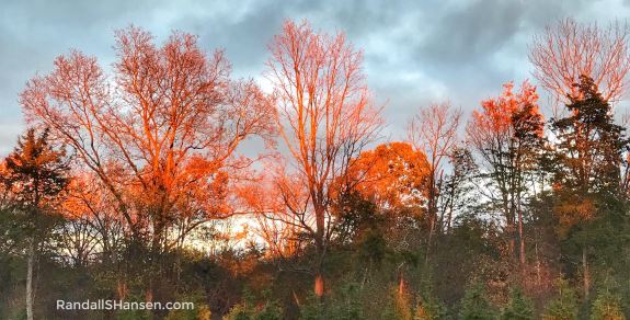
We parked at the AT trailhead along NY State Highway 17A in Warwick, not far from the Mount Peter Ski Area. (Warwick has been designated an official Appalachian Trail Community by the Appalachian Trail Conservancy.) We had a beautiful autumn afternoon hike in the woods, but worried about seeing the trail once the sun set, we only ended up hiking about 3.4 miles.
The next day we were excited to have a chance to get back on our bikes… and with colder weather always right around the corner, we are loving these opportunities to jump on our bikes.

The 14-mile Heritage Trail provides a 10-foot wide trail on the right-of-way of the former Erie Railroad. When the trail is completed, it will extend from the City of Middletown to the Village of Harriman. The absolutely stunning trail features sections of both asphalt and limestone surface as it travels through a bird/wildlife sanctuary, historic landmarks, murmuring streams, rolling meadows, and small communities.
We started the trail in Goshen, where there is excellent parking right along the trail, between Green Street and South Church Street. (Put Trailside Treats Creamery in Google Maps and you’ll find the parking area — and the trail.) We then biked southeast through Chester before turning around for a 14.5-mile bike ride; for those seeking the full ride, the trail continues to Monroe.
We loved learning some of the history of the railroad, seeing some of the old remnants — including signal boxes and an old siding (from the railroad’s days of shipping Orange County dairy farm milk to New York City). A fun stopping place was the old Chester Depot, built in 1915, which now serves as a museum — and where the Chester Historical Society holds its monthly meetings; the station is also open to the public on Saturdays in the summers. The mostly wooded trail also passes by the Jack & Louise Birnberg Nature Preserve, an 187-acre nature preserve just east of Chester that consists of former farm fields, wildflower meadows, woodlands, and wetlands — and which has two short trails for hiking.
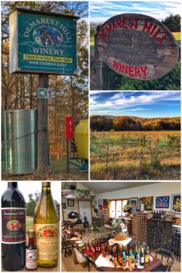
After the biking, it was time for a bit of wine-tasting — and we thought we would taste at the “oldest” winery in the United States, established in 1839… but we found its compound WAY too commercial and crowded for our tastes… and so we moved on to Demarest Hill Winery, located in Warwick.
We were a bit concerned about the winery as we drove up, first noticing the signage being a bit in disrepair, but as we got closer, also seeing the vineyards looking overgrown, unkempt, and full of grass and other weeds… in other words, untended. We later discovered that the winery owners are near retirement and have so much wine in barrels and bottles that they are no longer harvesting grapes. They seem to believe the winery will cease to exist once they die.
That said, we had a lovely tasting with Francesco and Orietta Ciummo. The couple came from southern Italy and landed in the Hudson Valley in 1980 after living and working in other countries and in New Jersey. But it was not until about a decade later that Francesco planted grapes … and since then, has been producing wines on this beautiful hilltop location. This master vintner has created 80 varieties of wine, spirits, and brandies; two ports and ciders; and four vinegars.
Some notes if you decide to taste at Demarest. First, they only take cash — for the tasting fee and any purchases. Second, it’s best to just let Francesco lead you on a tasting experience rather than choosing the wines you want to taste. Third, he is a bit soft-spoken and still has an accent, but he is wonderful in sharing his story and his creations.
We left with a bottle of their Warwick Red Deer and Peach Wine, as well as a bottle of their pure vanilla extract… and a hope that someone will buy the winery and save that vineyard!

From the Hudson Valley, we traveled along the Delaware River to a several-day stop in the Delaware Water Gap National Recreation Area. We stayed in at one of our LEAST favorite campgrounds, a KOA in East Stroudsburg in which the customer service was horrible, the WiFi worse, and an overall frustrating experience in which they also lost a package that the postal service said had been delivered.
Needless to say, we needed to immediately get out in nature… and happily once again hiked a portion of the Appalachian Trail that travels through the entire Delaware Water Gap. We parked at the Mount Minsi/Appalachian Trail parking area — just off Main Street in Delaware Water Gap, PA. The 5-mile (RT) hike to Mount Minsi is fairly popular, and we did see a few hikers on the trail as we hiked, but it was mostly quiet and wonderful. We weren’t up for hiking all the way to the top and were happy with some of the vistas we found along the way, ending up with about a 3.4-mile adventure. Side note: Mount Minsi (named after the Native American tribe of the area) forms the Pennsylvania side of the Delaware Water Gap, and is the eastern extent of the Blue Mountains, while Mount Tammany (the southernmost peak of the Kittatinny Mountains and named after the Native American Chief Tamanend) forms the New Jersey side of the Water Gap. The Water Gap is about 1,000 feet deep.
You might be asking yourself — what is the Water Gap? It is a cool geological feature on the borders of New Jersey and Pennsylvania where the Delaware River cut through a large ridge of the Appalachian Mountains.

After taking a day away from nature for work and errands, it was back to officially exploring the Delaware Water Gap National Recreation Area.
While Ran had visited the New Jersey side of the Water Gap many times, he never knew the fascinating story behind the creation of the National Recreation Area. It seems that back in the early 1960s, the U.S. Congress authorized the building of a dam across the Delaware River at Tocks Island, located upstream from the actual water gap. The dam was going to help supply water for New Jersey and New York while also supposedly controlling for flooding that previously occurred along the banks of the river. The government began buying up large parcels of land (including whole towns) to make room for the proposed dam’s massive reservoir until the U.S. Army Corps of Engineers determined that building the dam was not feasible. That land was then transferred over to the National Park Service along with the creation of the Delaware Water Gap National Recreation area in 1965. The 69,269-acre park straddles the east and west sides of the Delaware River and has about 260 miles of roads and more than 600 buildings (some preserved, some undergoing renovation, some used by the Park Service, some leased).
Speaking of buildings, the Park Service is in the process of moving visitor centers, and we made the mistake of trying to go to the Dingmans Falls Visitor Center — which Google said was open, but which is undergoing renovations and closed indefinitely. But we made the best of it by hiking the quite beautiful Dingmans Creek Trail — a fairly short (.6-mile RT) and accessible hike through a forested, pristine hemlock ravine that includes two waterfalls. The first waterfall is Silverthread Falls, which drops 80 feet in a tantalizing thin ribbon of water through a narrow, geometric chute. But keep walking for the real reward: Dingmans Falls, which is the second highest waterfall in Pennsylvania, dropping 130 feet as it cascades over rock ledges. If you want a decent birds-eye view of the falls and ravine, a short trail (with lots of stairs up and down — and obviously not accessible) leads to the top of the falls.
After the hike, we took matters into our own hands and crossed over to a Ranger Station, located in a building that used to be the Dingmans Ferry School. We met two highly-armed, but wonderfully friendly park rangers who gave us a short history lesson while recommending a few other places to hike.
We took their advice and headed to the newly reopened Hornbecks Creek Trail, a short (2.4-miles RT) and easy hike through beautiful woodlands, over several (rebuilt) scenic bridges, before ending at another gorgeous waterfall. (The old trail supposedly continues to the left of the waterfall continuing to the Indian Ladders and additional waterfalls, but the Park Service did not clear or officially reopen that part; the plan is to eventually reopen the remainder of the trail and connect it with trails at the Pocono Environmental Education Center, lovingly referred to as the PEEC by one of our friendly rangers).

After completing the Hornbecks Creek hike, we decided to complete our trifecta of trails by hiking a third trail up at the PEEC.
The Pocono Environmental Education Center is a non-profit organization with a mission to advance environmental education, sustainable living, and appreciation for nature through hands-on experiences. The PEEC has a large campus (the largest in the U.S.) with multiple facilities (including lodges, cabins, yurts, outdoor venues, and a dining hall) and offers all sorts of programs and camps to fulfill its mission. It also has about 12 miles of hiking trails. And the coolest part of the PEEC? It is located on what used to be one of those iconic Pocono Mountain honeymoon haven resorts especially popular from the 1950s through the 1970s when the Poconos were the “Honeymoon Capital of the World.” The PEEC sits on the grounds of the former Viking Heights, which the government purchased for the then-planned dam. (Unlike many other of the older and tacky resorts that did not change with the times and are now abandoned and crumbling, these facilities have been preserved.)
We debated a bit between the Ridgeline Trail (3.6-mile loop) and the Scenic Gorge Trail (1.5-mile loop), but eventually chose the Scenic Gorge Trail because we were interested in the hiking through a deep Hemlock forest… and while the trail was beautiful, we sadly learned that an invasive insect was rapidly killing off the Hemlocks. The woolly adelgid, accidentally introduced to the U.S. from Japan in the early 1950s, kills mostly hemlocks and some spruce trees by sucking sap, killing needles, and stunting growth. The woolly adelgid is now found all along the east coast in 16 states and seriously threatens Eastern and Carolina Hemlocks. (The Eastern Hemlock is the state tree of Pennsylvania.) Tree death takes several years, but even those trees affected but not killed often die from secondary factors because of their weakened state. One section of the trail even has warning signs to watch for falling trees — and boy, did we see a lot of fallen hemlocks.
Other trails at the PEEC include the Fossil Trail (a 1-mile loop), Tumbling Waters Trail (a 3-mile loop), and the Two Ponds Trail (a 1.4-mile loop).
The Delaware Water Gap NRA also has MANY other trails to choose from… so many that they actually break them down by their location in the park: northern, middle, and southern. The two longest trails through the park are the Appalachian Trail (21 miles) and the McDade Recreation Trail (31 miles). The McDade Trail is mostly flat and great for biking.
Besides scenic drives and hikes, you can also explore the area by canoe or kayak — by either renting from one of several authorized vendors or bringing your own. There’s also fishing, hunting, camping, horseback-riding, and picnicking opportunities throughout the park.
On our way back to camp, we stopped and admired the mighty Delaware River, which starts up in the Catskill Mountains of New York before emptying into the Atlantic Ocean near Cape May, New Jersey, and Cape Henlopen, Delaware. The river forms the boundary between Pennsylvania and New York — as well as with New Jersey. Fun fact: the early settlers dubbed the Delaware River South River and the Hudson River North River. Of course, the native Lenape called the river Lenapewihittuk, meaning the largest river in the area… or the rapid stream of the Lenape. The portion of the river in the park is the Middle Delaware National Scenic and Recreation River.
Next up for us? A homecoming of sorts for Ran, as we cross into New Jersey to visit family, see Ran’s old hometown, explore New York City, take in a few Broadway shows, and tour iconic locations.