

We left Wisconsin and headed into Michigan — state #25 — via the Upper Peninsula, or U.P. as most folks call it… arriving in the Munising area for yet another look at Lake Superior, this time on the southern shores, which offer stunning sandstone cliffs, sand dunes, and waterfalls — and most worthy of being recognized as a national lakeshore.
The U.P. is unique in many ways — a stretch of land 200 miles across and surrounded by three Great Lakes: Superior, Michigan, and Huron. The Munising area is known for its many waterfalls.
Like Voyageurs National Park, we had discovered that the best way to see the Pictured Rocks National Lakeshore on Lake Superior was to take a boat tour… so on our first afternoon in Michigan, we hopped aboard the National Park concessionaire Pictured Rocks Cruises sightseeing ship. Important tip: If you want a certain seat — say up on the top deck — make sure you arrive at least 30 minutes prior to departure and stand in line; with no instructions, we showed up about 10 minutes before departure and settled on (some actually nice) seats on the first deck. The ship makes a loop, so it does not necessarily matter what side you sit on, though the right side sees all the good stuff — the cool pictured rocks — up close first. You can move around some, but we recommend staking out a good window seat so you have unobstructed access to viewing and taking photos.

Pictured Rocks Cruises offers three tours: Classic, Spray Falls, and Sunset — each about 2.5-3 hours in length. We chose the Spray Falls cruise, which is a bit more expensive, but well worth it, as you can see in the cover photo for this blog post. The cruise follows the shoreline, past key highlights such as Grand Portal, Lovers Leap, Indian Head, Battleship Rock, Miners Castle, Flower Vase, Rainbow Cave, Painted Coves, and Chapel Rock… as well as the 70-foot Spray Falls. (The Sunset Cruise is generally only offered in June and July.) We lucked out with our cruise, which was late in the afternoon and offered the perfect weather to be on the lake and experience the beautiful scenery… because the next day, when we ventured back to explore the park by land, the lake was completely fogged in, with cruises cancelled.
The amazing sandstone creations found in Pictured Rocks are 500-million year-old Cambrian sandstone of the Munising Formation. The name Pictured Rocks comes from the streaks of mineral stains decorating the face of the cliffs; these streaks occur from groundwater oozing out of cracks in the rock. (The dripping water contains iron, manganese, limonite, copper, and other minerals — all of which stain the rock as the water trickles down the cliff.)
Besides the boat cruise, you can also kayak along these amazing cliffs. For example, Pictured Rocks Kayaking offers a 5-hour experience in which they take you from Munising Bay aboard a ship, unloading kayaks at Painted Coves, and letting you kayak for about 2 hours (and 5 miles) along the shoreline before returning to the ship — and back to Munising.
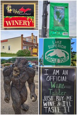
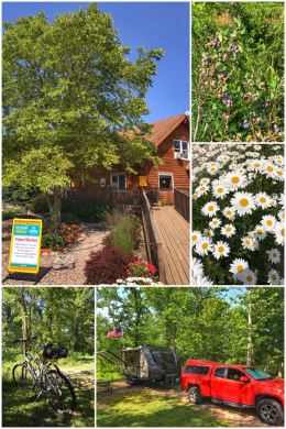
After the cruise, we spent some time walking around Munising — which gets its name from the Ojibwe word minisiing, which means “at the island.” (The town sits directly south of Grand Island, located in Lake Superior and now part of the Hiawatha National Forest.) The town is about 43 miles east of Marquette, the largest city in the U.P., and a major port on Lake Superior (mainly for shipping iron ore). The town is fairly small and has a variety of stores and eating establishments.
We, of course, found a neat little winery — Upper Peninsula Inspired — for a little wine-tasting. You can get three free tastes or pay $6 and get to keep the tasting glass and get a truffle. Since we already have a few too many souvenir tasting glasses from our travels, we opted for the free tastings.
We also ventured into a few of the gift shops in town — and again saw Big Foot, whose legacy certainly lives on in the U.P.
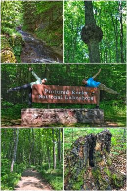
The next day, we officially ventured into Pictured Rocks National Lakeshore, starting with a stop at the Munising Falls Visitor Center (located on the west side of the park; a second visitor center, Grand Sable, is located on the east side, not far from Grand Marais.) We picked up a magnet and talked with a wonderful ranger who offered us all sorts of hiking suggestions. While the Au Sable Light Station and Grand Sable Dunes on the east side sounded appealing, we decided to spend the day mostly in the western section of the park, which offers lakes, waterfalls, beaches, and scenic overlooks — and numerous hikes. In fact, for the ultimate hike, one could along the entire coastline of the park (both up in the bluffs and down on the beach) by hiking a section of the North Country National Scenic Trail (a 4,600-mile recreation trail that travels from North Dakota to New York).
Pictured Rocks National Lakeshore protects 42 miles of Lake Superior shoreline and covers 73,236 acres (including the nearly 12,000-acre Beaver Basin Wilderness, which protects forests, streams, lakes, wetlands, and 13 miles of lake shoreline). It was the first authorized national lakeshore, designated to protect and preserve the shoreline, including the beaches, cliffs, and dunes.

We decided to start with the waterfalls, some located in the park — while others are located around Munising — starting with Munising Falls, a short and paved .25 trail up from the visitor center. The 50-foot falls drop over a sandstone cliff. We then drove over to the Miners Falls trailhead. The hike is fairly short (about 1.2 miles RT), though some stairs are involved to truly view the falls, which drop 50 feet over the sandstone outcrop. We also considered Mosquito Falls and Chapel Falls, two very popular hiking areas (including Mosquito Beach), but learned that the road to them had been shutdown because the parking area (which is fairly limited) was overflowing. Hint to the Park Service: Time to expand the parking if that area is one of the most popular in the park.
Happily, we did get to visit Wagner Falls and Alger Falls, both south of town. Wagner Falls Scenic Area is protected as a state park, and features a short (.5-mile) hike through virgin pine and hemlock trees. Wagner Creek falls over dolomite into a shallow gorge containing the Anna River, which flows northward into Lake Superior. Alger Falls is located right alongside Highway M-28, but it’s worth stopping for a closer look. The falls consist of a series of drops, the highest of which is about 15 feet — which you can only really see if you climb down and across Alger Creek.

The cool thing about Lake Superior (and most likely all the Great Lakes) is that the lake has a major impact on the weather; in one direction, it is sunny and gorgeous and you move to another side and it is completely fogged in.
As you can see from the pictures of the falls, the weather is sunny and clear, but when we hiked down to the Miners Castle Scenic Overlook, it was completely fogged in. After checking out the overlook, we jumped onto the North Country National Scenic Trail and hiked it a few miles in search of an elusive waterfalls that our ranger recommended: Elliott Falls. We never found it, but later discovered that the falls might best be found from Miners Beach, hiking the Lakeshore Trail; a creek makes a small drop and then makes a short plunge off a rock ledge before emptying into Lake Superior.
As we prepared to move on from Michigan’s Upper Peninsula, we were stunned to learned that all but one of the state’s 300 or so waterfalls are in the U.P., ranging in size from under 5 feet to 50 feet; many do require hiking to reach them, but most are well-known and the trails marked. Learn more about U.P. waterfalls here.
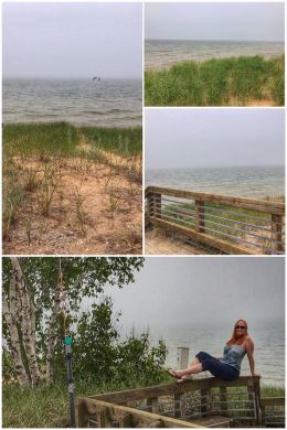
From Munising, we headed down toward Petoskey, traveling for a long portion along the shores of our second Great Lake: Lake Michigan. We again experienced the crazy weather patterns, where it was sunny at the beginning of the drive — and also at the end — but in the middle, near the north end of the lake (while still in the U.P.), it was foggy. We stopped near Brevort to take our first look at the lake — and snap some foggy photos! Fun facts about Lake Michigan: It is the only Great Lake entirely within the United States (the others are shared with Canada); it is also the second-largest of the Great Lakes by volume… and the third-largest by surface area.
By the time we got to the spectacular Mackinac Bridge, a suspension (toll) bridge spanning the Straits of Mackinac and connecting the Upper and Lower Peninsulas of Michigan, the sun was shining brilliantly… and we enjoyed the rest of the drive to Petoskey — a coastal resort community situated on Little Traverse Bay of Lake Michigan in the northwest part of the state.
Petoskey was named for Chief Pe-to-se-ga, of the Bear River Band of the Ottawa Indians. We absolutely loved the look and feel of this town, including finding a wonderful organic food store, Grain Train.

The town also has several excellent parks, including Bayfront Park, Sunset Park, and Water Front Park. At Water Front Park, we jumped on the Little Traverse Wheelway, a unique trail-to-rail-to-trail bike path (part of U.S Bicycle Route 35), that consists of 24+ miles of paved trail between Charlevois and Harbor Springs, following the curve of Little Traverse Bay. The corridor was first a pathway for penny farthing (high wheeler) bicycles before the Chicago and West Michigan Railway and the Grand Rapids and Indiana Railroad converted it to a rail corridor. By the 1970s, the rail corridor was abandoned and plans started for creating the rail-trail. A section of the North Country National Scenic Trail connects to the Little Traverse Wheelway — and Petoskey is an official trail town for the national scenic trail.
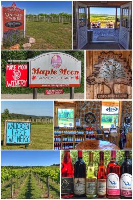
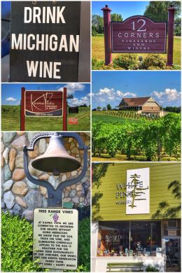
Petoskey is also a growing wine region, with 12 wineries belonging to the Petoskey Wine Region, part of the larger Tip of the Mitt American Viticultural Area (AVA). Traverse City is also a popular and more established wine-tasting destination (part of the Old Mission Peninsula AVA), but we preferred the smaller, more intimate setting of Petoskey.
We had a hard timing choosing which wineries to visit, but started out with Petoskey Farms Vineyard & Winery, about 4 miles east of town. (The winery also has a tasting room in town.) The winery’s tasting room sits up on a bluff and offers wonderful views. They offer wines with beautiful names, such as Love, Romance, Joy, Daily Bread — and their wines are produced exclusively from Michigan wines and fruit. We enjoyed meeting the winemaker, Josh Morgan, and learning more about his philosophy on the grapes and wines of the region. We happily left with a bottle of Romance ( a dry, full-bodied red wine produced from Michigan Merlot) and a bottle of First Crush (made mostly Estate Frontenac Gris, with 15 percent Estate Frontenac Noir added for color). We loved seeing the sign, In Vino Veritas: In wine, there is truth.
Next up was one of those unique experiences that we simply could not pass up — maple syrup wines from Maple Moon Winery, the first such winery in the U.S. The winery is just down the road from Petoskey Farms — and about 5 miles east of town. Besides the uniqueness of the wines — all from fermented maple syrup — we enjoyed chatting with the owners, Todd and Christi, who are strong Christians, and who include this bible passage on their website: “I am the vine; you are the branches. If you remain in me and I in you, you will bear much fruit; apart from me you can do nothing.” John 15:5. Their wines run from dry to sweet, and, of course, they have plenty of real maple syrup and maple syrup products in their tasting room. We left with a bottle of Early Spring Reserve (a dry, 100 percent maple wine, which we will pair with a batch of waffles one day soon) and Maple Moon Cherry (a semi-dry wine produced from Michigan cherries and maple wine).
Last up was Walloon Lake Winery, which was recommended to us, but we also had to go since it has our Loon Lake in its name! The family-run winery is located about 5 miles southwest of town and focuses on creating quality wines produced from cold-hardy grape varieties. We also loved that the winery believes in sustainability: “… dedicated to being good stewards of the earth and committed to treating the earth gently with all the decisions made on the farm.” The tasting room itself is a cool experience — produced with cordwood construction using cedar logs harvested from the farm. We had a great tasting there and ended up leaving with a mixed case of Regatta (a dry rose composed of Marquette, Frontenac Gris and La Crescent grapes) and Randall’s Point Red (a delicious fruit-forward, off-dry wine, with a name we could not resist).
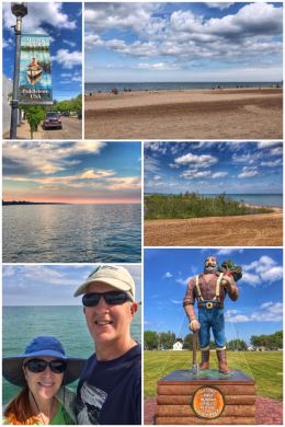
Our next stop in Michigan was Oscoda, a small town on the eastern side of the mitt — located on Lake Huron, our third Great Lake! We chose Oscoda because we wanted to experience Independence Day (July 4th) in small-town America and because of its location near the lake and the Au Sable River. In fact, the town proudly touts its watersports, calling itself Paddletown USA. The nearby Huron National Forest (part of the Huron-Manistee National Forests) is also a big draw. Forestry is still a big thing, but it was a major thing a century ago — which is why there is a Paul Bunyan statue in the middle of town, celebrating the annual Paul Bunyan Days Festival in Septembers. (The festival includes wood chainsaw carvings, classic cars, carnival amusement rides, and a pie-eating contest).
Lake Huron — the second-largest of the Great Lakes in terms of surface area (at 23,007 square miles) and the third-largest by volume — is connected with Lake Michigan by the 5-mile-wide Straits of Mackinac. Its name comes from French explorers who named the lake for the Huron People who once lived in the area. Lake Huron has the largest shore line length of any of the Great Lakes, counting its 30,000 islands — and we twice enjoyed walking some of that beach in Oscoda Beach Park, just east of downtown. Like the other Great Lakes, Lake Huron was formed by melting ice as the continental glaciers retreated toward the end of the last ice age.
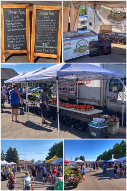
We spent a fun morning at the Wednesday Farmers Market, located at Au Sable Shoreline Park, in the Chamber of Commerce parking lot. (There is also a companion market on Saturdays in Tawas City, south of Oscoda.) We were happily surprised at how big it was, with many vendors selling a variety of items, from fresh farm eggs, lots of veggies (though many were imported from out of state), baked goods, and some local meat vendors — including Standen Acres, which offers pasture-raised pork, lamb, and beef. We were in search of fresh berries and veggies, but since none were local, we instead left with a dozen eggs and several selections of pastured pork and lamb, which we are looking forward to grilling later this summer. We especially loved buying from the brother/sister team at Standen Acres… we HAVE to support these local farmers and ranchers who are struggling to make a living while raising crops and animals the right way.
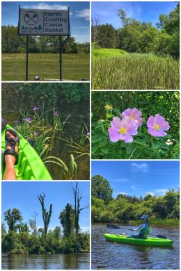
We went for more water adventures after the farmers market — renting kayaks from North Country Canoe Rental, located just south of town. The company offers just about any type of self-propelled “boating” experience along the Au Sable River, including renting canoes, kayaks (single/doubles), tube, and paddle boards — with options for the two-hour (7-mile run) or four-hour (13-mile run). We chose to rent individual kayaks and do the 7-mile trip down the river.
The Au Sable River is one of the more scenic in the state — and is touted as one of the best canoeing rivers in the Midwest. Its name come from the French, au sable, meaning at the sand. It runs for 138 miles before flowing into Lake Huron. Along those 138 miles, it has six hydroelectric dams that can produce more than 48,000 kilowatts of power. The Au Sable has been designated a blue ribbon trout stream by the Michigan Department of Natural Resources — and is one of the best fly-fishing rivers east of the Rockies. The river is also the site of the annual 120-mile (running from Grayling to Oscoda) canoe race, the Au Sable River Canoe Marathon, which begins one evening in late July and runs through the night into the next day. Much of the main branch of the river flows through the Huron National Forest — including the part that we kayaked.
River Road, which runs parallel to the Au Sable, is a National Scenic Byway and National Forest Scenic Byway, running for 22+ miles — and we drove the entire length of it on our way into Oscoda.
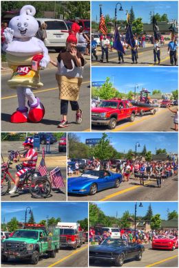
We spent the 4th of July rejoicing in the celebration of America, small-town style… starting first with a parade down main street and concluding with a concert in the park and fireworks.
We arrived just on time for the parade, which featured more floats and groups than we expected, concluding with the usual firetrucks and rescue vehicles.
The concert in the park featured an 80s glam-hair cover band — with a lead singer who took breaks for interesting costume changes. When the concert finally ended (which seemed about five songs too long after the sun went down), the fireworks show (launched from the pier) started. We left early to avoid the crowds, but watched the finale not far from where we parked the truck. Overall, the town celebrates America just right!
Our final fun in Oscoda was another drive into the Huron National Forest to do some hiking — but also to see one of the highlights of River Road: The Lumberman’s Monument (located bout 15 miles west of Oscoda). The monument honors the lumberjacks who worked and lived in the area in the late 1800s, during a time when the Au Sable River was a major transportation route for floating the clear-cutting of the giant white pines down into Lake Huron and to the sawmill towns located around the lake. We were conflicted because clear-cutting is not an acceptable practice, especially with such old-growth trees, but what happened here in Michigan and other northern woods led to better forest practices, which is a good thing.

We used the Lumberman’s Monument stop to accomplish several things. First, to see the monument and read about the history. Second, to check out the visitor center and discuss hikes and buy a magnet and another pin (a forest service pin) for Ran’s hat. Third, to enjoy the Au Sable River overlook. Fourth, to hike the Dune Trail and part of the Highbanks River Trail. The short Dune Trail takes you to a massive perched sand dune 120 feet above the Au Sable River that 15,000 years ago was a glacial lake; you can also find perched dunes in Pictured Rocks National Lakeshore, but these dunes are unusual because of their interior location along a river. The Highbanks River Trail is a 7-mile trail along the forested bluffs of the Au Sable River; from the Lumberman’s location, you can go west for about 3.5 miles to Iargo Springs or east for about 3 miles to Cooke Dam Road.
While it was too hot to hike all the way to Iargo Springs along the Highbanks Trail, we did drive over to it and hike the 300 steps down (and back up) — along a 200-foot vertical drop — to the springs and views of Cooke Pond. The name of the springs comes from the Native Americans who lived in the area, meaning many waters. A spring is a natural source of water that flows from the ground. By the way, there’s also a nice observation deck at the top, and not all visitors do the hike down and up the stairs.
From Oscoda, we zagged back west across the state to the Ludington area, located on Lake Michigan. We stayed at one of the worst campgrounds — and certainly the worst KOA — and if traveling in this area, we would recommend Vacation Station RV Park. The KOA seemed to cater more to tenting campers and families; the RV spots were close together with limited trees near the campsites, the staff a bit too nosy and over-the-top, the roads all sandy and dusty, and the showers bizarre (with no way to control the temperature, which was set way too hot for the summer).
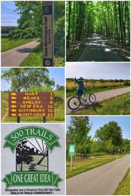
That said, the Ludington area was beautiful, with forest, river, trails, and wineries — a perfect mix for us. We decided to start our adventures with a 15-mile bike ride along the quite peaceful William Field Memorial Hart-Montague Trail State Park, an almost 23-mile paved trail between Montague and Hart that travels through farms, orchards, and forests — including including a portion of the Manistee National Forest. (We biked adjacent to apple and cherry tree orchards and asparagus farms, as well as through lush forests.) It is named for the man who bought the old rail corridor and donated it to the state for a recreational trail. The first half opened in 1989, with the second half completed in 1991; in 2016, the trail was widened and resurfaced. The trail follows the route developed by the Chicago and Michigan Lake Shore Railroad in 1872… and after a series of mergers and change of ownership, CSX finally shut the line down and removed the tracks in 1982. The trail, which was one of the first rails-to-trails projects in Michigan, has been designated as one of America’s First 500 Rail Trails, by the Rails to Trails Conservancy.
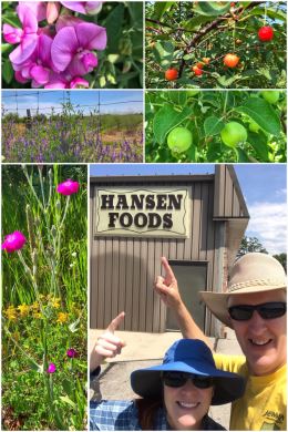
We started the bike ride in the town of Hart, about 24 miles south of Ludington. The trailhead, which includes a bathroom and large parking area, is located on Polk Street just southwest of town, not far from U.S. Highway 31. The town was named Hart because of its central position in the “heart” of Oceana County.
And the coolest part? Right next to the trailhead is Hansen Foods, a neat little local grocery store. (No relation to us, of course, but we were tickled.)
The trail between Hart and Shelby (where we turned around) was truly beautiful, and we witnessed wildflowers, vetch, apple trees, and cherry trees.
For people who want more fun and adventure, the trailhead in Hart is just east of Silver Lake State Park — an almost 3,000-acre park that includes mature forests and more than 2,000 acres of sand dunes.
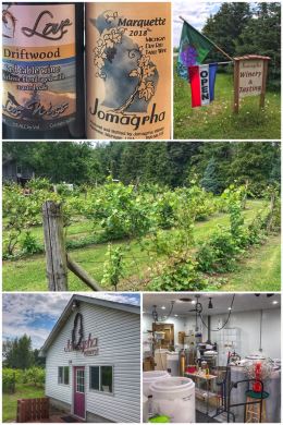
We opted for some wine-tasting after our bike ride… starting with the very small and unique Jomagrha Vineyards and Winery, located in Pentwater — about 10 miles south of Ludington. Established in 1999, this family-run winery makes small batches of handcrafted wines from locally grown grapes — including wines produced from old-world French hybrid grape varieties to new generation hybrids, as well as the traditional Bordeaux and Burgundy vinifera varieties. We met with owner/grower/winemaker John Sanford, and tasted a variety of wines, including a few whites along with our traditional reds. (Tastings are $1 a piece; 5 tastings maximum.) We wanted to like more of their wines, which include names like Bison Red and Old Man Red, but settled on one bottle of their 2018 Marquette, a varietal we have generally enjoyed in this part of the country.
We then traveled up to downtown Ludington to taste at Love Wines. (Since we are all about love and kindness — and wine-tasting — how could we pass up this winery?) We had a fun time tasting a broad selection of their many wines (currently in the 15-20 range). The winery specializes in country style wines — produced in their “wine lab” — with a bold fruit forward flare, although they also have a selection of more traditional wines as well. We left with a bottle of their Driftwood, a red table wine.
Both Jomagrha and Love wineries are part of the Michigan West Coast Wine Trail.
While in downtown, we stopped at the Biercamp Market, where we happily discovered Norwegian wild-caught salmon, some wonderful cheeses, and our hard-to-find Rebel (sugar-free) ice cream. Score! Its a great little supermarket that also carries wines, prepared foods, and much more.
Finally, while in the area, we had hoped to stop at The Jam Farm, which uses locally grown fruit and produce to create wonderful jams, jellies, and butters… but ran out of time. (They make several sugar-free versions, and Ran loves grilling pork with jam to create a salty-sweet delight.)

We ended our adventures in the Ludington area with more time kayaking on the river — this time on the Pere Marquette River — which runs for 64 miles from Lake County into the Pere Marquette Lake… and from there into Lake Michigan. We used River Run Canoe Livery, located about 9 miles east of Ludington, which offers a quite delightful 6-mile run from Custer to Scottsdale. We rented individual kayaks ($25 each, including paddles, cushions, and drop-off) and had an extremely peaceful float/ride down the river. You can’t see it in the picture, but Ran had a dragonfly hitch a ride on his hat for quite some time; in fact, the massive number of dragonflies along the river was certainly a highlight. Some people pack a picnic and swimsuit and make a day out of it, but we enjoy paddling down the river without stopping — unless it is for pretty flowers or wildlife!
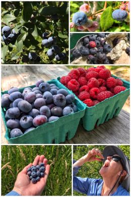
We next traveled to Covert, Michigan, located in the southwest part of the state, along Lake Michigan… and we were blessed with fulfilling one of our many goals on this trip: picking ripe, sun-warmed berries. In fact, our campground had rows and rows of blueberry plants, so we picked everyday we camped there; we had also hoped to pick raspberries, but had to settle on fresh berries picked by the farmer that morning. In our minds, nothing beats fresh berries — for snacking, salads, ice-cream, and muffins! We arrived just at the start of blueberry season — and relished in the joy of these healthy berries! As we explored the area, we found blueberry u-pick farms throughout… but only one u-pick raspberry farm: Riverbend Farms.
The Covert/South Haven area is a great place to visit — lots of fruit farms, vineyards, and orchards, with the bonus of being right on Lake Michigan (and near the resort towns of St. Joseph, Saugatuck, and Holland.) Covert is the sleepy town while South Haven is much more tourist-centered, offering lakeside fun for the entire family, a walk-able downtown with unique shops and restaurants, and tons of maritime history, arts, live music, and culture. There is also a wonderful farmers market in town — and a great blueberry shop where we bought blueberry-infused coffee.
But let’s start with a top recommendation for camping at the Covert/South Haven KOA Holiday, one of the best KOA Kampgrounds we have visited — and one of the best overall of any 100+ campgrounds we have visited. Evening ignoring the amazing blueberries (which is hard to do), we found the staff friendly, the grounds and bathrooms clean, our site shady and private, and the location perfect. There’s also a ton of stuff for the kids, but it is not in your face like other campgrounds. In fact, the most kids we saw from our campsite were a bunch of bunnies that entertained us each morning and evening. Did we mention the WiFi? Great WiFi, one of the VERY few campgrounds that have upgraded their technology. It’s obvious the people who own and manage this campground take customer service seriously. After the Ludington campground, it was a joy to again control the temperature of our showers!
We spent two days wine-tasting here, trying to cover a broad spectrum of the 18 wineries that are part of the Lake Michigan Shore Wine Trail. From Covert, one can travel north, east, and south to find all sorts of interesting wineries.
On our first day of tasting, we decided to head south, starting our fun at Karma Vista Vineyards, located in Coloma (about 9 miles south of Covert). We were a bit hesitant because the winery lists all these rules on their website — no large groups, no late arrivals, no spitting — but we were happily surprised by how relaxed their style was once we got inside! What they do NOT mention on their website is that they believe in sustainability and good farming practices. They offer a selection of 20+ wines from dry to sweet, including some fruit wines, with 5 tastings for $5. We fell in love with their Moondance Merlot, purchasing 2 bottles. Next up was 12 Corners Vineyards, located in Benton Harbor — about 20 miles south of Covert, but only 6.5 miles from Karma Vista. (For convenience, 12 Corners also has a tasting room in South Haven.) The tasting at 12 Corners costs a bit more ($10), but you also get a souvenir (juice-sized) glass. They offer white and red wines from dry to sweet, as well as hard cider and ice wines. We tried a variety of dry wines and actually left with a bottle of their Traminette, a rare white wine purchase for us. We ended our first day of tastings at the aptly named White Pine Winery, located in St. Joseph, and about 7 miles west of 12 Corners. White Pine produces a range of white and red wines using varietals such as Pinot Gris, Merlot, and Cabernet Franc. The winery is named after the Michigan state tree — and the owner and winemaker (Dr. David Miller) is a noted viticulturist with more than 30 years of experience. We enjoyed our tasting and left with a bottle of fruit-forward Serendipity (a Bordeaux-style blend of Cabernet Sauvignon, Merlot, and Cabernet Franc).
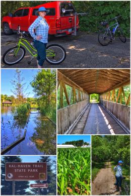
The next day we hit the trail — the Kal-Haven Trail Sesquicentennial State Park — on our bikes to explore yet another rail-trail. This 34-mile former railroad corridor — one of the oldest conversions in Michigan — has a limestone/slag surface and connects South Haven to Kalamazoo, traveling near the Black River (a 42-mile river that empties into Lake Michigan), crossing over bridges, passing through small towns, forested areas, and farmland (mostly corn and blueberries), as well as several points of historical interest. We loved the diversity of this trail and were amazed again to see flooding along the river. One unique aspect of the trail is that it crosses seven bridges — most built in 1870 for the railroad and converted for the trail more than a hundred years later. The Kal-Haven Trail runs along the original route of the Kalamazoo and South Haven Railroad, which was bought out by the Michigan Central Railroad (and finally by Penn Central)… before the line was abandoned in 1970. In Kalamazoo, you can connect to the Kalamazoo River Valley Trail for 21 more miles of trail. (Also in Kalamazoo: an old red caboose offers trailhead services.) Also of interest to some: An 11-mile section adjacent to the main trail provides access for horseback riding.

Next up was more wine-tasting, this time heading north from Covert — starting with Cogdal Vineyards, a family-run winery located about 13 miles north of Covert, just off the Blue Star Highway (which is a cool road that hugs Lake Michigan). They produce small-batch wines using all Michigan-grown grapes. Tastings are 5 tastes for $5. We tasted several wines, including the Big Lake, Vision, Cabernet Franc, Merlot, Vin Rouge, and Reflection… but fell in love with their V.P.S. (Vision Private Selection), a tasty medium-bodied red, and left with a bottle. We considered a stop at Crane’s Winery, but were told that almost all their wines were sweet, so we instead headed up to Fenn Valley Vineyards, located about 12 miles north of Cogdal (and about 25 miles north of Covert). Fenn Valley is a splendidly landscaped, third-generation, family-owned vineyard and winery that produces premium red and white wines, sparkling wines, as well as hard cider. They offer two complimentary tastings, as well as 5 (additional) tastes for $5. They also offer tours, but only on weekends. We tried a few of the sparklings and several of their dry reds (including Caberet Rose, Capriccio, Meritage, Zweigelt, and Chambourcin). We left with four bottles — two sparklings and two reds.
Many grape varietals grow well in this region because of the “lake effect,” which brings warm days and cool evenings… with warmer water temperatures lingering during fall so that the vineyards benefit from extended harvesting period while the grapes finish ripening. The colder lake of winter and early spring also protects the plants (and buds) from late frosts. Most of Michigan’s wines grapes are grown within 25 miles of Lake Michigan!
We also went in search of fresh fruit and other goodies while wine-tasting. We tried Dutch Farm Market, which offers some u-pick options, as well as other local fruits and vegetables and other goodies (such as jams, jellies, salsa, etc.) — but finding no fresh berries, we moved on to another of our favorite foods…. cheese. We drove to Fennville’s Evergreen Lane Farm, which has an amazingly delicious and creamy selection of goat cheeses produced from the milk of LaMancha goats. We tasted multiple samples of sublime goodness before settling on a tub each of herb and garlic and a tomato basil. (As we were driving off, we wondered almost immediately if we should have bought in higher quantities!)
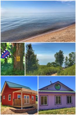
On our way back to the campground, we stopped off at a little roadside park and hiked a short trail down to a beach along Lake Michigan. We stood and enjoyed the views — and then Ran went in search of a few more rocks for his collection.
From Covert, we once again zagged across the state, to Tecumseh (about 26 miles southwest of Ann Arbor) — a big agricultural and industrial area of the state that is located along the River Raisin, a river that sadly has been polluted by industrial and agricultural runoff. The River Raisin flows for about 139 miles in southeastern Michigan, controlled by several dams, eventually emptying into Lake Erie. The river’s name comes from the French word for grape, as French settlers called it the La Riviere aux Raisins for the wild grapes that grew along it banks.
We considered visiting Ann Arbor or Detroit while in the area, but instead focused more on nature than big cities, twice exploring the many trails of Heritage Park, a community park in Adrian, about 15 miles south of the campground.
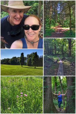
Heritage Park offers an interesting mix of trails, but also features softball fields, soccer fields, bicycle trails, benches, playground, picnic shelters and tables, grills, disc golf, and a sledding hill.
We spent one afternoon on hiking from the main trailhead — Stubnitz Trailhead — enjoying the 2.7-mile Red Trail. (Other trails from this location include one longer one and several shorter ones.) The second afternoon, we parked at the alternative trailhead (near the soccer fields) and hiked the 3-mile Heritage Loop Trail, which was perhaps even a bit more enjoyable. The trails zigzag through the woodlands, with some moderate hills. We saw old fencing and other artifacts from when the park was a family farm.
We spent one more unexpected morning in Adrian when we discovered one of our travel trailer’s tires had a bad leak… and we ended up replacing two of the tires at the Discount Tire in town — getting a great deal and fantastic customer service.
Next up we do a big counterclockwise loop through Indiana, Ohio, and Illinois, and then back eastward… making a special zag to stop in Cincinnati and visit with dear friends.