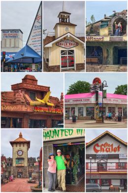
We left Duluth and immediately crossed over the St. Louis River into Superior, Wisconsin… on our way to Osseo for a quick layover before arriving at our official first stop in state #24 — Wisconsin Dells, “the Waterpark Capital of the World,” and most certainly a major tourist attraction (a small sampling of which can be seen in the photo collage). The town boasts of having the nation’s largest outdoor waterpark, the state’s largest indoor waterpark, and the largest combined waterpark resort.
But first…Wisconsin, the Badger State, and most certainly still the dairy capital of the U.S. The state gets its name from the mighty Wisconsin River, a tributary of the Mississippi and the state’s longest river — which was originally called the Meskousing by the Algonquian-speaking tribes and later anglicized into Wisconsin.
Cheeseheads are an endearing way to describe cheese-loving Wisconsinites. The first cheesehead was worn at a Milwaukee Brewers (baseball) game, not a Green Bay Packers (football) game. Ginseng is grown in Marathon County, in the middle of the state — and produces nearly all of what is grown in the U.S. (and about 10 percent of the world’s supply). Cranberries are also a BIG thing in Wisconsin, with the bogs in the state producing about 60 percent of the nation’s cranberries. (And the little town of Warrens draws about 100,000 visitors to its annual cranberry festival each September. The state capital is Madison and the largest city is Milwaukee –and we avoided both. Snowmobiling is big in the state; it is also home to more than 15,000 miles of signed and groomed snowmobile trails.
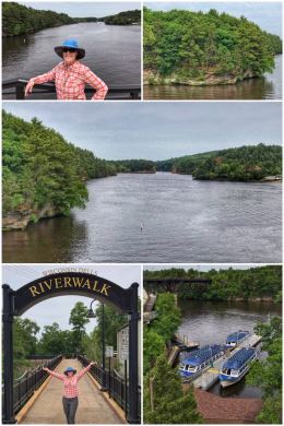
We spent much of our time in the state near the Wisconsin River, which has been labeled “the hardest working river in the U.S.” because of its 25 operating hydroelectric power plants that dam major portions of the river, creating nearly one billion kilowatt hours of renewable electricity annually.
We started our adventure in Wisconsin Dells (formerly known as Kilbourn City) taking a stroll along the town’s River Walk, a .25-mile paved trail that follows the river bank, offering glimpses of the unique scenery here, as well as benches and tables for relaxing, and interpretative signs providing visitors with the history of the area — including that he Dells hold great significance to the Ho-Chunk People (who lived in an area from Michigan to Illinois).
The Wisconsin River and the Dells were early drivers to all sorts of folks, but the town itself has lots more touristy stuff not related to either — including indoor and outdoor waterparks, miniature golf, amusement parks, ziplines, go-karts, and escape rooms. You name the activity — and the town probably has at least one! Of course, there is also tons of shopping and a host of types of places to stay.

We knew we wanted a river adventure — to see those Dells up close and personal — and we chose to go with the Original Wisconsin Ducks, one of several tour operators using amphibious vehicles that travel on land and water. The tradition of these tours began back in 1946 when two entrepreneurs brought a single one of these amphibious vehicles used in World War II as landing crafts in D-Day and other operations. For you geeks, the DUKW is a modification of the 2.5 ton CCKW truck — a six-wheel drive vehicle modified with a propeller in the back — and nicknamed the Duck by soldiers. General Motors designated the vehicle as D (designed) U (utility) K (all-wheel drive) W (dual-tandem rear axles). More than 25,000 DUKWs were built during World War II.
The Original Wisconsin Ducks tour is a blast! You first travel along private, wooded trails as your guide explains the history of the area in a fun and amusing way… and then suddenly you splash into the Wisconsin River and have the opportunity to view the Lower Dells up close. Then we cross up into a creek, maneuvering around sandbars, until back up on land briefly before a BIG splashdown into Lake Delton… before ending back on land, through the forest. We absolutely loved the experience — and loved playing tourists! Check out the fun on their website: Original Wisconsin Ducks
How did the Dells come about? A prehistoric proglacial lake, Glacial Lake Wisconsin, existed in the central part of the state… and when temperatures warmed about 15,000 years ago, the ice dam holding the lake in place broke open, unleashing a massive flood that carved the Dells of the Wisconsin River, a 5-mile gorge (with cliffs as high as 100 feet in some areas) that showcase beautiful Cambrian sandstone rock. The Dells are protected as a State Natural Area.
Interesting fact. While the Dells were created by the flooding waters from melting glacial activity, this area of Wisconsin is part of the large Driftless Area that was bypassed by the ice. The Driftless Area — something we had never heard of until Ran’s son mentioned it to us — covers an area including southwestern Wisconsin, southeastern Minnesota, northeastern Iowa, and a tiny portion of northwestern Illinois… it is an area that escaped glaciation during the last ice age and is characterized by steep, forested ridges, deep river valleys, underground streams, caves, and spring-fed waterfalls. The Mississippi River passes through some of the Driftless Area, helping form the Mississippi Flyway (a key path for migratory birds). The Driftless Area is also home to many artisans of all sorts — who find inspiration in its beauty and a peaceful place in which to work.
We can’t say enough about this beautiful area of Wisconsin — and besides the river and the Dells and all the crazy amusement distractions, there are even more opportunities for people who love the outdoors — including three nearby state parks, including Mirror Lake State Park, Rocky Arbor State Park, and Devil’s Lake State Park. Almost everyone we talked to recommended the very-popular Devil’s Lake for the spectacular cliff scenery, but we were looking to get away from crowds… and it is also the farthest from town (and we generally avoid parks named Devil). FYI, besides the state parks, there are also two State Natural areas, including Hubert Creek Woods Natural Area (which lies between Rocky Arbor and Mirror Lake State Parks) and Blackhawk Island State National Area (located just to the northeast of Rocky Arbor along the Wisconsin River).
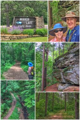
We chose Mirror Lake State Park, located just 6 miles south of Wisconsin Dells. The 2,179-acre park contains the 137-acre glassy-smooth namesake lake, which has sandstone cliffs that reach up to 50-feet high. The park includes trails, picnic areas, camping sites, a swimming beach, fishing pier, and boat rentals. The trails include 28 miles of hiking trails, 17 miles of cross-country skiing trails, 9 miles of mountain-biking trails, a 1-mile snowshoeing trail. We first hiked the beautifully forested Northwest Trail (a 2.3-mile loop), which can be accessed right behind the park office. after that hiked, we drove to the Cliffwood Campground and hiked the Lakeview Trail (which did not have much of a lake view) up to the Echo Rock Trail, which was a fun little hike with an overlook of Mirror Lake and some very cool rock formations at the end. Other hikes include Ishnala (2.2 miles), Hastings (2 miles), and Fern Dale (3 miles).
After the park, we headed down to Madison to take care of some business, including hitting up yet another Costco and getting some of our key supplies of macadamia nuts, lamb chops, Havarti cheese slices, avocado oil, and a rotisserie chicken (which only Costco cooks flawlessly).
The next day was more exploring of the town, including a stop at Carr Valley Cheese, an artisan cheese company that has been operating for more than 100 years and which creates more than 100 cheese varieties from cows (mostly), goats, and sheep — including Cheddar, Colby, Pepper Jack, Gouda, Havarti, Caso, Bolo Mellage, and Sheppard’s Blend. If you know us at all, you know we are massive Cheeseheads… we believe cheese should definitely be one of the key food groups. We left with several chunks of cheese and more salsa. The store is a fun stop and the whole downtown has lots of interesting stores and restaurants — and offers great people-watching.
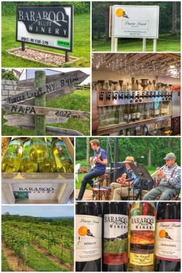
Our final adventure in the Dells area was a little wine-tasting, starting with Baraboo Bluff Winery, located about 14 miles south of town. This small, family-run winery actually started in the basement of their house; they now have a large tasting room with three large bar areas. For a $5 tasting fee, you can taste all nine of their wines (if they are all in stock). They grow La Crosse, Prairie Star, Petite Pearl, St. Pepin, Frontenac, Itasca, and Verona grapes on five acres. We enjoyed the tasting and sharing the excitement of our travels with some of the staff — leaving with a bottle of Sangiovese and The Angell (a perfect wine to have with eggs). We then traveled up to Prairie Hawk Winery, a fairly new winery located about 7 miles northeast of town, which produces grape wines, fruit wines, ciders, and meads. We happened to be tasting on a Friday evening and they were just starting their summer music at the winery — and so besides enjoying a tasting, we also enjoyed sitting outside and listening to the Thomas Burns Trio. We loved hearing the story of the winery — which like several others we have visited, started with wine-making as a hobby. We enjoyed the tasting even though many of the grapes are not locally grown, and left with a bottle of their Merlot and Zinfandel.
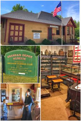
From the Dells, we traveled to Gresham, a small “village” located along the Red River, and about 50 miles northwest of Green Bay. It includes the Upper and Lower Red Lakes, both 190+ acre lakes with boat launches and fishing opportunities.
Besides the fishing, there’s not a whole lot to do in the area — and the cellphone coverage and WiFi were definitely pretty limited (except at a nearby casino), but we had to stop at the Gresham Depot Museum, which was the depot for the Wisconsin Northern Railroad (known as Whiskey North); and later for the Soo Line Railroad… until it was closed in the early 1960s and then relocated to its current spot in the 1970s. The former depot is now filled with mannequins, telegrapher’s equipment, railroad lanterns, timetables, freight wagon, and other Gresham historical memorabilia — and we had a wonderful member of the Gresham Women’s Club show us around.

After the depot tour, we headed south of town to find the rail-trail that runs through town and hiked several miles of it deep into the country. The Mountain-Bay State Trail — the longest rail-trail in the state — is an 83-mile state-designated rail-trail that runs through three counties: Brown, Marathon, and Shawano. It is named for the two geological features at either end of the trail: Green Bay and Rib Mountain — and was developed by the Wisconsin Department of Natural Resources and the parks departments from the three counties. The trail has a mix of surfaces, from dirt and grass up to gravel and asphalt as it follows the rail corridor of a secondary Chicago & North Western (C&NW) line that ran west of Green Bay, carrying mostly agricultural freight.
Cool fun fact: The Ice Age National Scenic Trail follows the Mountain-Bay State Trail corridor for about two miles between Ringle and Hatley in Marathon County. The Ice Age Trail winds for more than 1,000 miles through the state, following the edge of the last continental glacier in Wisconsin.
As we left Gresham, we were happy with some peaceful time in nature, including seeing our first fawns. We were also overjoyed to discover a nearby horse farm that had six donkeys in their pasture. (Donkeys/burros are our spirit animal — and we love them dearly.)

Our last stop in Wisconsin was Land O’ Lakes, a cute little town in the north-central part of the state that is located amidst the world’s largest chain of inland lakes. We stayed at a very nice little campground aptly named Borderline RV Park, as we were camped within a mile or so of the Wisconsin-Michigan (U.P.) state line… and literally right next to the Wisconsin River. We were also camped just two miles from the Wisconsin River’s headwaters, and so, like with the Mississippi River, we had to go in search of where this mighty river begins… at the southwest corner of the 4,260-acre Lac Vieux Desert, one of 25 or so lakes that surround the small town.
Other lakes in the area include Loon Lake (!!!), Big Lake, Birch Lake, Clearwater Lake, Crystal Lake, Duck Lake, Forest Lake, Indian Lake, Little Portage Lake, Moon Lake, Thousand Island Lake, and West Bay Lake… and as you might guess, fishing is big here. As you can see from the collage, Big Foot seems to have lived here too — perhaps moving west as the forests of this area were clearcut by Paul Bunyan and his fellow loggers. (Logging was a big industry a century ago; today, it is tourism.)
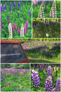
The biggest — and most wonderful — surprise of this stop was arriving as the lupines were in full bloom. Lupines were everywhere, including fields of them by the side of the road. These big-leaf lupines are bigger and fatter than the lupines of northeast Washington… and they were wonderful, but they also made up miss our H3 (Hansen Hilltop Haven). Lupines are part of the legume family Fabaceae… and the Romans actually cultivated the beans. Legumes — including lupines and vetch — are soil-enhancing plants, taking nitrogen from the atmosphere. Legumes also lower soil pH, increase soil porosity, recycle nutrients, and diversify the microscopic life in soil.
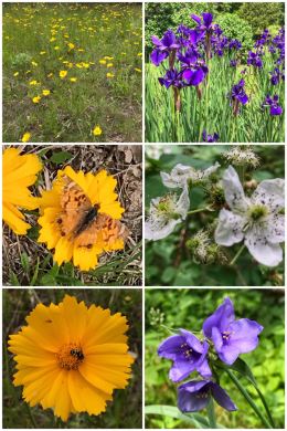
Before our lupine fix, we had been a bit disappointed in the wildflowers we have seen in these last three states (Minnesota, Wisconsin, and Michigan), but finally we are starting to see more blooms and more diversity… and the recent batch of lupines and daisies definitely make us happy!
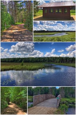
Next up for us was a hike along the Three Eagle Trail, starting at the Sundstein Road Trailhead, located about 23 miles south of Land O’ Lakes and about 15 miles northwest of Three Lakes (which is where the south trailhead is located; in total, this part of the trail is about 8 miles long). We hiked about 4 miles to Mud Creek and back, hiking through mostly forest until reaching the floodplains of Mud Creek. Along the way, we happened upon our first porcupine, just munching on some plants along the side of the trail. So exciting! Along this section of the trail, there is also a potty, water fountain, and a cool picnic pavilion. The trail is part of an effort to have multiple hiking and biking paths for the communities, with hopes that it will connect to additional trails and communities.
After the hike, we drove down to Three Lakes to do a little wine-tasting at Three Lakes Winery. The town is named for the three primary lakes in the area: Maple, Townline, and Range Line lakes. It formally became a town in 1881 and had its starts in logging until it and most of the northwoods area was clearcut. Happily, in the 1930s, the Civilian Conservation Corps (CCC) began an effort to replant the trees — and today, logging and forestry is still a thriving (and better managed) industry in the area.
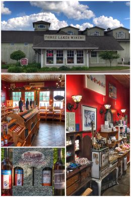
Wisconsin has five wine regions: Driftless (southwest), Glacial Hills (southeast), Fox Valley (east-central), Door County (northeast, along lake Michigan), and Northwoods (entire northern part of the state).
Three Lakes Winery, a family-run winery, is the only winery located on the northeast part of the Northwoods Region; it has been producing wine since 1972 — the second-oldest winery in the state. All their wines are made from local fruits and berries, with a few blended grape wines and chocolate wines. Because the area is a great cranberry-producing region, the winery offers several cranberry varieties — and the cranberry is still their top-selling wine. Their wines range from dry to sweet.
The tasting room is located in the former Chicago and Northwestern train depot, built in 1880, and visitors can taste up to seven wines… at no cost! They even include several fruit-infused cheese plates between tastings. (The tasting room also features their cheeses, as well as other local meats, cheese curds, drinks, and wine-related products.) We left with a bottle of their Zinfandel, Cabin (cranberry and blackberry), and Old Glory (cranberry and blueberry)… we also picked up another bottle of Old Glory at a local grocery store — selling for about $3 cheaper than at the winery… which is not the first time we have found wine to be MORE expensive to buy at the winery, where logically the wines should be cheaper because there is NO distribution costs; one day, some winery will give us the rationale, but we do not understand it.

We ended our time in beautiful Land O’ Lakes — and in Wisconsin — biking a part of the Wilderness Lakes Trails, a 40-mile multi-use trail loop that, when finished, will encircle the Sylvania Wilderness of the Ottawa National Forest (located in Michigan). We started our bike ride from the trailhead/parking area at Black Oak Lake, just west of town. (The trail starts in town, but becomes more scenic as you bike westward and into the Forest Lake Trail.) About 13 miles of the bike path is paved, with another 12 miles on a gravel/aggregate surface. Still other parts of the route run alongside roadways. We had a great bike ride through the forest and along creeks and lakes — but the mosquitoes got to us again, and we headed back for the safety of our trailer!
Next up we head into Michigan for several weeks… first in the U.P., and then zigzagging down across the state and adding two more Great Lakes (in addition to Lake Superior) to our list.
