
We left Cortez and headed north to Montrose, with a focus on our 36th national park: Black Canyon of the Gunnison.
The south entrance to the park, which is the only one that remains open in the winter, is located about 15 miles east of Montrose. (The park closes most of the park to allow for cross-country skiing, but when we were visiting, much of the South Rim Road area was completely clear of snow — and yet still closed to vehicles.) The north entrance is located about 11 miles south of Crawford — and there is no bridge over the canyon, so it is sort of like two separate parks.
The Black Canyon of the Gunnison was established as a national monument by President Herbert Hoover in 1933, during which time the Civilian Conservation Corps (CCC) built the North Rim Road of the park, including five miles of roadway and five overlooks. It was not until 1999 when it became a national park. The park protects a little more than 30,000 acres, including about 12 miles of the 48-mile long Black Canyon.

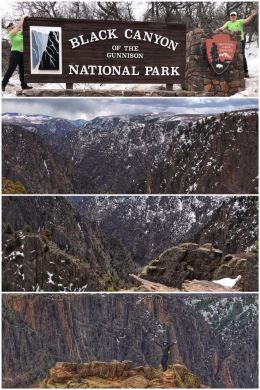
The Black Canyon — so named because its deep, steep walls only allow minutes of sunlight to reach the base (from 1,800 to 2,250 feet below) — has a fascinating history.
Several million years ago, the Gunnison River began carving the canyon, stripping away softer volcanic ash and rock from ancient eruptions during the creation of the Rocky Mountains and leaving gneiss and schist (foliated metamorphic rocks) comprising the canyon walls. It is one of the best exposures of ancient (nearly 2 billion years old) Precambrian-aged rocks in the world.
The Ute Indians knew of the canyon — and avoided it out of superstition; they called the Gunnison “much rocks, big water.”
In the mid 1850s, John Williams Gunnison led an expedition for the Pacific Railroad, seeking to find a safe route for the railroad to lay tracks from St. Louis to San Francisco. Along his journey, he came across the Black Canyon and deemed it impossible to pass — labeling it “the roughest, most hilly and most cut up.” The river, originally named the Grand, was renamed in his honor when he was killed in a Ute Indian raid later that same year.
Later in the 1880s, the wealthy owner of the Denver and Rio Grande Railroad, actually built a 15-mile narrow-gauge roadbed in the base of the canyon to carry gold and silver from nearby mines in the San Juan Mountains. (His surveyors and engineers told him it was impossible, but money and determination prevailed.) The railway was used for both freight and passengers until better routes were found — and the Black Canyon line was abandoned in the 1950s.

In early 1900s, the government decided they needed to do something about bringing water to the dry Uncompahgre Valley, and built what was then the world’s longest irrigation tunnel — at 5.8 miles — through the canyon walls… at the cost of millions of dollars.
We spent two days at the park, with the first day doing our usual orientation at the visitor’s center — watching a movie, talking with the rangers, and buying a magnet. We also checked out the two canyon overlooks that are located directly behind the building.
The next day, we came prepared with our hiking boots and walked the Rim Rock Trail, along with part of the South Rim Road up to the first overlook — Pulpit Rock. The Rim Rock Trail offers some amazing vistas, but was a bit mucky and slushy in parts — but well worth the effort, especially with our hiking sticks for balance. The 2-mile walk along the roadway was a bit boring, but the overlook at Pulpit Rock — especially of the emerald/teal green Gunnison River — made it all worthwhile. (When we returned from the hike along the roadway, Ran chatted with a ranger about why the road was still closed and was informed that the road might be opening soon; they were “re-evaluating” the situation. The Rim Road — and its several overlooks — is most worthy of hiking, biking, or driving.
The pictures here do not do the canyon justice — it is sheer and deep and has spectacular rock formations. And once in a while, as you are hiking along the rim or at an overlook, you get glimpses of that once-mighty but still beautiful river.
Next up, we head to Grand Junction as we continue our clockwise travel through the state.