
We ended our travels through Texas with a little two-step dance through the towns of Huntsville and Beaumont.
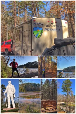
Huntsville is approximately 70 miles north of Houston in the East Texas Piney Woods and we camped out in the very pretty 2,083-acre Huntsville State Park, located about six miles southwest of the city. The park, established in 1956, has many buildings and structures constructed by the Civilian Conservation Corps (CCC), and is dominated by loblolly and shortleaf pine trees. The park includes the 210-acre Lake Raven, which has been known to be frequented by alligators (though we did not see any). While we liked the park, we found the facilities a bit dated and in need of some rehabbing.
Our favorite hike was the Prairie Branch Loop, a 1.5-mile trail that goes through both a mixed pine and hardwood forest and along the shore of Lake Raven. Other hikes include the Triple C Trail (8.5 miles RT), Chinquapin Trail (6.8 miles RT), and Dogwood Trail (1.8 miles).
While we mostly walked the trails within the park, we did also briefly hike into the adjacent Sam Houston National Forest, one of four national forests in the state. The forest contains about 163,000 acres, and is located between Huntsville, Conroe, Cleveland, and Richards, Texas.
Huntsville also contains a 67-foot tall steel-and-concrete statue of Sam Houston, one of the founding fathers of Texas, and the first (and third) president of the Republic of Texas. He was key figure in the Texas Revolution against Mexican forces, including leading the defeat of the powerful General Santa Anna — which secured Texan independence. Later, he represented Texas in the U.S. Senate. The statue is a tribute to the man who lived and died in Huntsville — and is the ninth tallest statue in the U.S.
The second part of our two-step was a stop in Beaumont, a city in southeast Texas with a population of more than 110,000, and a major industrial player on the Texas Gulf Coast. After the discovery of oil, it grew as one of the major petrochemical refining areas in the country.
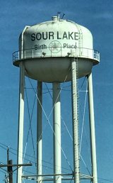
On our way to Beaumont, we drove through Sour Lake (part of the Beaumont metro area). In the early 1900s, the town became a booming oil town (with a population as high as 10,000) — and is noted as the birthplace of the Texas Company in 1903… which later changed its name to the familiar Texaco. (Texaco is one of four oil companies that can be traced to the oil boom of southeast Texas.) Today, the Sour Lake oilfield is the oldest continuously-producing oil field in the world… and the population of Sour Lake has dropped to fewer than 2,000. By the way, the town was originally named Sour Lake Springs after the medicinal springs found in the area — and by the late 1800s, the town had become a full-fledged health resort, endorsed by none other than Sam Houston.
Our time in Beaumont was a combination of grading for Ran and schoolwork for Jen, but as we often do wherever we stop, we sought out nature and hiking… which led us to discover multiple National Wildlife Refuges just south of Beaumont, including Anahuac National Wildlife Refuge, McFaddin National Wildlife Refuge, and Texas Point National Wildlife Refuge.
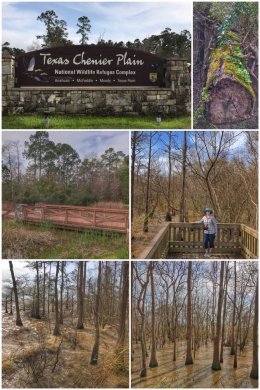
We started at the Texas Chenier Plain Refuge Visitor Center, which serves as a center of information for all the refuges — and which offers a fun multidimensional film in seating set up to resemble an airboat. The visitor center sits near the banks of Lake Anahuac, and a short boardwalk hike leads you to the edge of the lake, which is simply a breathtaking experience — and should not be missed. The 35,000-acre artificial lake — it was once Turtle Bay until the mouth of the bay was closed in the early 1900s — is fed by the Trinity River, a 710-mile river in eastern Texas.
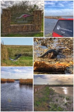
From the visitor center, we headed south to the Anahuac National Wildlife Refuge, which was established in 1963 and protects about 37,000 acres of coastal marsh (including both fresh and saltwater marshes) and prairies, providing habitats for resident and migratory birds… including waterfowl, wading birds, shorebirds, song birds, and raptors. The western edge of the refuge is on the eastern edge of Galveston Bay.
We thoroughly enjoyed the Shoveler Pond Auto Loop, a 2.64 mile drive surrounding the 220-acre pond — and which includes a .14-mile boardwalk into the pond. (It was along the boardwalk that Jenny spotted the adolescent alligator.) We also hiked the Willows Trail and Butterfly Garden (a .71-mile accessible trail that starts near the visitor center) and the Hackberry Trail (a .67-mile trail with an observation platform.) Besides driving and hiking, the refuge also allows hunting and fishing opportunities.
And with that last stop, we leave Texas — state #14 on this journey — and head into Louisiana. As we look back, we have to say that if there is one place to visit in Texas, it has to be the Big Bend, but eastern Texas also has its charm (and humidity).