

We made it to West Virginia… the 48th and final state we are visiting on this journey. (Alaska and Hawaii will come in future trips.)
We had planned to spend a bit more time traveling through the state and exploring more of its beauty, but Covid-19 and the fears and changing political landscape around the virus forced us to make some major adjustments to our plans.
We started our adventures in West Virginia outside of Barboursville, located just east of Huntington, the state’s second largest city. Sadly, the town’s parks and trails were all shut down from fears — at a time when people really need to be out in nature (while obeying physical distancing rules). But, because the rainy weather is still following us, we did not have too much time for hiking anyway.
What did we do? We did Jazzercise on Wheels! To help fill the void for people looking to get their dancing and exercise fix, Jazzercize corporate decided to run a series of Facebook Live workouts… and we had a blast rocking and rolling — and working out — in the trailer. (Jazzercise also offered free on-demand classes too.)
Happily, things changed when we arrived at our next location, Pipestem, a small town in a rural area in south/southwest West Virginia located between the Bluestone National Scenic River and the New River. (Sad fact: the Bluestone River has been compromised by PCB contamination, largely left over from former coal mining operations.) The town’s name comes from a common shrub found in the area — narrowleaf meadowsweet — which has historically been used for making pipe stems… and it is the perfect location for plenty of recreational activity! This area especially fits the state’s nickname of the Mountain State.
The great thing about Pipestem is that there is a multitude of state parks and forests within an hour’s drive — and some just a few minutes nearby. We stayed at a very nice little campground, Pipestem RV Park.
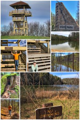
We started our self-prescribed forest bathing and hiking at Pipestem Resort State Park, located in the gorge of the Bluestone River, and described as a “premier family adventure resort.” (Fun fact: the park was built in 1963 with grants provided by the Area Redevelopment Administration under President John F. Kennedy.)
The 4,050-acre park truly has something for everyone… including two lodges, 26 cottages, 82 campsites, two golf courses, mini-golf, disc golf, gift shops, restaurants, conference facilities, aerial tram, zip line, indoor and outdoor pools, nature center, riding stables, tennis and game courts, hiking trails, lookout tower, amphitheater, picnic shelters, guided trout fishing trips, and more. Most things — restrooms, playgrounds, and buildings — were of course closed, but the trails were open for adventure!
We knew we wanted to hike around Long Branch Lake, so we parked near the (closed) swimming pool across from the McKeever Lodge. We found the Den Tree Trail, which leads directly to the Lake Shore Trail, where we headed left for a clockwise hike around the lake. The hike is moderate, but muddy! We ended up hiking about 3.6 miles… and while we saw a few people on the trail, everyone was friendly and respectful. We ended our visit to the park with a short (.5-mile) hike up to the Bolar Observation Tower, which sits on the highest point in the park (3,000+ feet), and offers wonderful views of the Appalachian Mountains.

The next day we decided to explore Bluestone State Park, a 2,154-acre park established in 1950 and located along the western shore of Bluestone Lake, an impoundment of the New River — built and managed by the U.S. Army Corps of Engineers. The heavily-forested and mountainous park is named for the Bluestone River, which flows into the New River at the park. Like Pipestem Park, all the buildings and facilities were closed. (Happily, the state provides downloadable maps of all the parks.)
The park’s main focus is offering visitors boating and fishing opportunities, but camping (and cabin) and hiking options are also available. Our goal was hiking near the river, so we drove down to the Old Mill Camping Area to do a loop starting with the Big Pine Trail, which connects to the Overlook Trail, and then finishing with the River Trail. We found the campground partially submerged and the banks of the Bluestone River swollen. Sadly, we also found the trails very overgrown… so we modified our plans and hiked partially along the road and partially along the river up to Meador Camping Area, which was also partially flooded. An odd, crazy, but fun hiking adventure.

The next day, which was amazingly sunny (and also quite warm), we decided to tackle two more state parks, starting with Brush Creek Preserve and Falls State Park, a 124-acre park located near the confluence of Brush Creek and the Bluestone River. The roads to get here are narrow and crazy, with a few blind curves, but it’s worth it to see the creek and the falls. (The park is actually near I-77, but there is no easy access.)
The 25′ falls are accessible by a short and rocky (and sometimes muddy) .25-mile trail. Most folks stop there, including us, but the trail continues for another 1.5 miles into a Nature Conservancy Preserve and another small waterfall.
Our main hiking plan was Camp Creek State Park and Forest, which is known for its beautiful waterfalls, great fishing, and nice campgrounds. With nearly 6,000 acres of dense forest, 35 miles of trails (for hiking and horseback riding), and seven miles of seasonally stocked trout streams, the area offers something for everyone. Camp Creek State Park officially became a state park in 1987, after 550 acres were marked off from the Camp Creek State Forest. Unlike Brush Creek, Camp Creek is an easy drive off of I-77.

Our goal was to hike to two waterfalls within the park: Campbell Waterfalls and Mash Fork Waterfalls. What we should have done was to park near Mash Fork Campground and hike up to Mash Fork Waterfalls on Turkey Loop Road and Trail…from the falls, take Mash Fork Falls Trail to the Blue Jay Spur Trail to another section of the Turkey Loop Road to Campbell Waterfalls. What we did was park right inside the park and hike the Turkey Loop Road, part of which is open to vehicle traffic. (There are gates near both waterfalls.) It was a fine hike — about 3.2 miles roundtrip — but hiking along a road is not our ideal… we like being in the forest!
If we had more time in the area — and with the Covid-19 crisis growing daily, we do not — we would have considered at least another day trip to the Canyon Rim Visitor Center of the New River Gorge Scenic Area, as well as to Sandstone Falls. (The New River Gorge Bridge along US-19 is one of the longest steel arch bridges in the Western Hemisphere.) There are also a few other beautiful spots… this whole area really fits the state slogan of wild and wonderful.
Speaking of West Virginia fun facts… the state is the only one to be admitted to the union under presidential proclamation when it broke away from Virginia during the Civil War and was admitted on June 20, 1863, by order of President Abraham Lincoln. Organ Cave is the largest natural cave in West Virginia — and the third largest cave in the United States. Nearly 75 percent of the state is covered by forest. The state bird is the Cardinal (as with several other states) and the state tree is the Sugar Maple. Not surprisingly, coal has been a major industry in the state.
We wish we could have spent more time in the state, but the governor ordered all state campgrounds to close — and many commercial campgrounds decided to follow that same order and close. Bleh.
And so… we made one more stop at a national park before making the trek back to Washington.