

The second half of our adventures in Minnesota (state #23) took us to Bemidji, International Falls, and Duluth… to amazing natural areas with lots of history (some good, some bad)… and smack into the heart of mosquito and tick country!
We also discovered northern Minnesota seems to be the land of giant statues. (Keep reading to discover the ones we found!)
We started our adventures in Bemidji, known as the capital of the state’s northwoods. It’s a charming small town that also has the title of “The First City on the Mississippi” because the river’s headwaters are not far from town. It is also the alleged (proclaimed?) birthplace of Paul Bunyan, a lumberjack whose exploits at logging grew and grew in folklore as stories circulated in lumber camps all around the country. In those stories, Paul was often accompanied by his big blue ox, Babe. It’s told that Paul was a huge baby (it took five storks working in teams to deliver him) who grew up to 63 ax handles tall; Babe, when fully grown, was 42 ax handles wide (from one horn tip to the other). The giant lumberjack could cut down acres of timber in just a few minutes by simply swinging his huge ax on a rope… and Babe could haul the logs away as quickly as Paul cut them down. They traveled across the U.S., cutting down forests from coast to coast — but always returned home to Bemidji to fish in play in the many lakes they created in the area (including Lake Bemidji)… or so the stories go.
Paul Bunyan Park celebrates the legend with the statues seen in the pictures. Both were constructed in 1937; Paul stands at 18 feet tall while Babe is about 10 feet tall. Both have been listed on the National Register of Historic Places since 1988. Behind the statues, sits the mighty Mississippi River/Lake Bemidji, and just a bit further is the statue of Chief Bemidji (also known as Shaynowishkung). The park also includes a playground and several trails, including the 112-mile Paul Bunyan State Trail (the longest continuously paved trail in the U.S., running between Bemidji and
Brainerd along an abandoned Burlington Northern Rail Corridor). A Tourist Information Center is also located in the park and has restrooms, brochures and maps, exhibits, and a helpful staff.
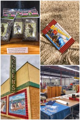
After visiting the park, we decided to support the local economy with a bit of shopping, starting first at the Lumberjack Shack, right across from the park where we bought a Paul Bunyan magnet.
We then headed into town and the Bemidji Woolen Mills, which for almost 100 years have been producing a fine line of woolen clothing, sweaters, and blankets… right in Bemidji; the factory is right next to the store. Founded in 1920, they also sell quite few other brands in the store — including Pendleton, Wigwam, Woolrich, and FoxRiver. They also sell a few touristy items, such as wild rice, soups, postcards, and more. We felt compelled to support such a truly American-made brand and left with a beautiful new wool scarf — with plans to special order one of their amazing blankets once we build our new home in northeast Washington. (Ran was tempted by their very heavy Paul Bunyan Jac Shirt, but decided against it… for now.)

Next up was the Harmony Natural Foods Co-Op, located across the street from the Bemidji Woolen Mills. The store, while a co-op, is open to the public, and offers local, organic, and sustainable products… including produce, dairy, meats, and wellness products. We found all sorts of goodies in the store — including wild-caught salmon, local meats, and the ever-elusive (but so wonderful) duck eggs. We also bought ingredients for the next batch of Ran’s Organic Buttermilk Ranch Dressing, which he makes from scratch (including the mayonnaise base), a low-carb and healthy dressing and dip!
But the must-see, must-visit spot near Bemidji is the state park that protects the headwaters of the Mississippi River.
Everyone who knows Minnesota told us we would love Itasca State Park… and they were right!

The 32,690-acre park, the first state park of Minnesota and the second oldest in the entire nation (established in 1891), contains more than 100 lakes, including the lake that is the headwaters of the Mississippi River. It also protects and preserves about a quarter of the state’s remaining old-growth red and white pine trees.
The park includes campgrounds, a lodge, a scenic drive, and plenty of hiking, biking, and boating opportunities (as well as snowshoeing and cross-country skiing in the winter). It is located about 33 miles southwest of Bemidji and 21 miles north of Park Rapids. The park was named a National Natural Landmark in 1965 and added to the National Register of Historic Places in 1973.
We started at the Mary Gibbs Mississippi Headwaters Center in the northern end of the park. The plaza contains lots of interpretative signage, but the highlight for sure is the short trail that takes visitors to the Headwaters of the Mississippi River at Lake Itasca — which was finally found (after many searches) by Henry Schoolcraft in 1832. The sign on the edge of the lake states: “Here at 1,475 feet above the ocean the mighty Mississippi begins to flow on its winding way 2,552 miles to the Gulf of Mexico.” (Today, the river is about 200 miles shorter due to channelization.)
Fun facts: The Mississippi River is the largest river (based on volume) in the U.S. and the second-longest after the Missouri River. On our adventures, we have crossed the Mississippi multiple times, including in six of the 10 states it runs through: Louisiana, Mississippi, Arkansas, Missouri, Iowa, and Minnesota. (We may see it again as we travel through Illinois, Wisconsin, Kentucky, and Tennessee.) Lake Itasca is 1,077 acres and about 45 feet deep, and contains about 6 billion gallons of water… and from that lake, and with numerous other creeks and rivers (tributaries) draining into it along its journey, the Mississippi River grows in size and volume before reaching the Gulf.

From the Mary Gibbs Mississippi Headwaters Center, we headed southwest on the 10-mile Wilderness Drive, which is beautiful on its own as it winds around the Itasca Wilderness Sanctuary Scientific and Natural Area (a 2,135-acre parcel that remains completely unaltered and untouched)… and traveling near old-growth pine stands, but which also has numerous places to stop and hike.
We started our hiking adventures at the Landmark Trail. The parking area here includes a much-needed and detailed kiosk listing all the hiking trails, self-guided trails, and interpretative stations you’l find along the drive. The Landmark Trail includes signage designating the Itasca Natural Area as a National Natural Landmark in 1965, the first in Minnesota. It’s a neat hike through a Ponderosa Pine stand that have never been logged. It was along this trail that we really learned why some folks joke that the Minnesota state bird is the mosquito, as swarms came down and around us — and especially on Jen.
Regaining our sanity in the sun, we decided to also hike the Blowdown Trail, located across from the Landmark Trail, which showcases the effects of a tremendous windstorm that hit the park in 1995… but even with an extra dousing of insect repellent, we only managed to get about halfway through the trail before we raised the white flag on those swarming, blood-thirsty pests!
After regrouping again, we did manage to hike the CCC Plantation/Forestry Demonstration Trail (a red pine and white spruce forest replanted — after formerly being clearcut — by the Civilian Conservation Corps in the 1930s), Large White Pine Trail (highlighting the massive white pines that existed prior to logging), and Large Red Pine Trail (which takes you through an area of old-growth red pines, including what used to be the largest red pine in the park). Other trails you could hike along the way include the Bohall Trail (which ends at Bohall Lake) and the Nicollet and DeSoto Trails (both also cross-country skiing trails in the winter).
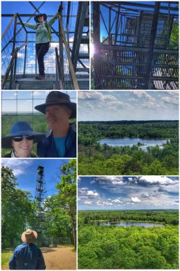
Toward the end of the drive, the last stop — and a very popular one too — is the Aiton Heights Fire Tower Trail, a 1-mile (RT) hike that leads up to a 100-foot restored (in 1998) fire tower. It was originally built near the park headquarters, but moved to its present location in 1937. The trail includes two small lakes — Kerry and Allen Lakes — but the tower is the ultimate reward.
Only six people are allowed to be on the tower at one time, and the rule seemed pretty well self-managed while we were there… and the views from the top — looking in all four directions — was truly a birds-eye view of the park and the land beyond.
For a longer hike, one can connect with the Aiton Heights Trail, which goes to Douglas Lodge… our next stop on the drive. Douglas Lodge, built in 1905, offers lodging and dining (and meeting/event) options from Memorial Day weekend through October. It includes the Forest Inn, built in 1941 by the Veterans Conservation Corps. (President Franklin Roosevelt expanded the CCC program by creating the Veterans Conservation Corps in May 1933.)
It’s also in this area that Lake Itasca Tours operates a small tour boat. The almost two hour narrated tours run more frequently in the summers — mostly in the early afternoons. Schedules and fees can be found on their website.

Several hikes can also be accessed from this area, including the Mary Lake Trail and the Brower Trail (named in honor of the park’s founder, Jacob V. Bower). We decided to hike the third trail, the Dr. Roberts Trail, which winds for two miles through pine, aspen, oak, and maple stands, as well as several bogs.
The main attraction for us on this trail is the Old Timer’s Cabin — a CCC-built cabin that used such massive trees that the full-sized cabin is only four logs high — as you can see in the picture, with Ran standing in the doorway. Built in 1934, this small, rectangular building with gabled roof is among Minnesota’s first CCC-built state park structures.
We ended our visit to the park with a stop at the Jacob V. Bower Visitor Center, located on the eastern edge of the park. The center includes exhibits, a gift shop, and restrooms. We also watched a short film on the park — and the search for the headwaters of the Mississippi River.
Other hikes in the park include the Eagle Scout Trail, an east-west connecting trail that passes numerous lakes, connecting with the Deer Park, DeSoto, and Nicollet Trails; it also serves as the North Country National Scenic Trail through the park.

Our final bit of fun in the Bemidji area was a surprisingly different and wonderful wine-tasting experience at Forestedge Winery, located about 25 miles south of town.
Located in Laporte, on the edge of the Paul Bunyan State Forest, this winery offers seven wine tastings — for a fee (which is not mentioned on their website). But the fee was not the surprise; the amazing part of the tasting is that ALL the wines come from a variety of mostly local fruits — none of which are grapes. The fruits include chokecherry, blueberry, cranberry, rhubarb (grown on the property), pear, plum, black current, raspberry, and apple. The tasting menu consists of 21 (!) wines that range from dry to sweet. We quickly became fans of their wines — and left with six bottles, including two varieties of Paul Bunyan Red (made from different varieties of black currants and plum). We guarantee you will be pleasantly surprised!
We did not have the time, but the winery also houses (in a separate building pictured in the collage) an art gallery featuring art and fine crafts from local Minnesota artisans. The place should definitely be on your must-visit list when in the area.
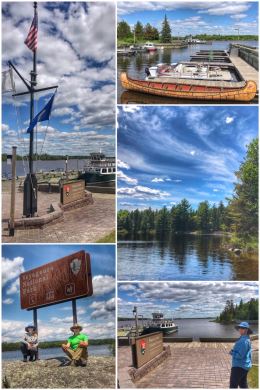
From Bemidji, we headed all the way up to within a mile or so of Canada, camping in the town of International Falls — and within a short drive of Voyageurs National Park, our 38th visited on this grand adventure!
Voyageurs National Park is one of the “newer” parks, established in 1975. It encompasses about 218,200 acres (much of it water and islands, accessible only by boat) and celebrates the French-Canadian fur traders who traveled through the area in the 1700s (mostly trading for beaver). Of course, there were many earlier native inhabitants of the area, including the Ojibwe, who were the primary residents when the voyageurs arrived. Interestingly, there was also a very short gold rush in this same area in the late 1800s (1893-98). Commercial fishing became the next big thing, starting in the late 1800s and lasting for several decades before collapsing and leaving small family-run fish camps.
The park has three visitors centers — and we visited them all! We started at the Rainy Lake Visitor Center, which is the only one open year-round — and which is the closest to International Falls, located about 12 miles east of the town off State Highway 11. (Some say this section of the highway should be known as the “Gold Highway” as much of the crushed ore waste (mine tailings) from the most successful mine — the Little American Island Gold Mine — was used as a gravel base for the roadway.) We started with the movie, of course, then bought a magnet, chatted with the rangers about hiking and boat excursions, and then headed out for a short hike on the 1.7-mile (RT) Oberholtzer Trail, which includes two lake overlooks as you walk through forest and wetlands. (FYI: All three visitor centers show the same park movie, but Rainy Lake is also the location of the where you can take a Voyageurs National Park boat tour.)

Unfortunately for us — or perhaps fortunately — the national park boat tours did not start until June 16, the day we were moving on to our next location. Happily, we were camping at Arnold’s Campground, and we were able to hire Pat (who mostly does fishing excursions) to take us on a 2.5-hour tour of Rainy Lake, the largest of the four major lakes in the national park at 227,604 acres and a maximum depth of 161 feet. (The other three lakes include Kabetogama Lake, Namakan Lake, and Sand Point Lake — and together they make up about a third of the total area of the national park.) Pat, who was born and raised in International Falls, and his wife Lisa, took us all around a small part of Rainy Lake, including islands with eagles nests, several beaver lodges, and the locations of several national park sites (houseboat, tenting, day-use) — many of which were once private property owned by family friends before the park service acquired the land — and all are only accessible by watercraft! (There are about 150 campsites and more than 270 visitor-use sites located in the four lake regions.)
We thoroughly enjoyed the boat tour, even briefly crossing into Canadian waters (which is totally legal, as long as you do not stop). We had thought about actually driving over into the town in Canada across from International Falls — Fort Frances — but we have just found we do not like the attitudes of most of the personnel we have encountered at border crossings. For those who want to see the lakes in a canoe or kayak, several outfitters in the area rent them, as well as most other types of boats — including houseboats.
Other fun facts about Voyageurs: The national park includes more than 900 islands! Several small fish camps that once thrived are also preserved in some form; the Harry Oveson Fish Camp has been restored and is now a destination to stop (with a new dock and new toilets) and the Hilke Fish Camp has some amazing tent sites. Gold was found in Little American Island, which led to the development of Rainy Lake City (on the western shore of the Kabetogama Peninsula; today, very little remains of either, but you can take a .25-hike on the island and see several of the abandoned mine shafts and learn about the very short gold rush. There’s also the Kettle Falls Historic District, which we did not visit, that includes a historic (and working) hotel built by a timber baron in the early 1900s.

Even with all the lakes and islands, the national park does indeed have several hiking opportunities — mostly centered around the three visitor centers. At Rainy Lake, we hiked the 1.7-mile (RT) Oberholtzer Trail, which offers two scenic overlooks as you walk through forest and wetlands. (There’s also a nice biking/hiking path: The Rainy Lake Recreation Trail, a 12-mile paved path that extends from the visitor center to International Falls.) At the Ash River Visitor Center, we hiked several short trails, including the .5-mile loop Voyageurs Forest Overlook Trail (which is totally overgrown and not worth the mosquitoes), the Beaver Pond Overlook, a .2-mile trail to a lake overlook, and the Kabetogama Lake Overlook Trail, which connects to the Blind Ash Bay Trail (resulting in about a 3-mile RT hike). We had planned to also hike the Sullivan Bay Trail (a 1.5-mile RT hike), but the weather and bugs got the best of us — and we were done for the day.
For folks looking for a much more strenuous hike, the Kab-Ash Trail — which rangers told us to avoid when we visited — a 28-mile trail that connects the Kabetogama and Ash River communities, traveling through forests and wetlands.
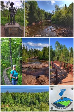
International Falls is also home to a giant voyageurs statue, erected and now dedicated to the former mayor of town Edmund C. Woods Sr. And just west of town is Smokey Bear Park, which has a 26-foot Smokey, the largest in the U.S.

From International Falls, we traveled down and over to Duluth, a major port on Gitche Gumee (the name the Ojibwe People gave to the lake was gichi-gami, meaning “great sea”) — Lake Superior — the largest freshwater lake in the world in area (at 31,700 square miles) and the third largest in volume (at 3 quadrillion gallons); it holds 10 percent of the world’s surface fresh water and is fed by more than 200 rivers! The glacier-carved lake, the largest of the Great Lakes, is 350 miles east-to-west and 160 miles north-to-south, with an average depth of 489 feet (and maximum depth of 1,276 feet).
The lake touches Minnesota, Wisconsin, and Michigan in the U.S. (and Ontario in Canada). Lake Superior also has the highest elevation of all five Great Lakes, and drains into the St. Mary’s River. The British were the ones to finalize its name as Superior (mistaking a French name for the lake) — “on account of its being superior in magnitude to any of the lakes on that vast continent” … and the lake is truly fitting of its name. The lake has been immortalized in culture as Gitche Gumee, including in Henry Wadsworth Longfellow’s The Song of the Hiawatha” and Gordon Lightfoot’s 1976 hit song “The Wreck of the Edmund Fitzgerald.”
We hiked parts of the Gitchi Gami State Trail — shown in the collage above –a planned 89-mile non-motorized, paved recreational trail along the lake’s beautiful and historic North Shore. Several segments of the trail, totaling about 29 miles, are complete.
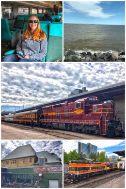
But we started first in Duluth, the fourth largest city in Minnesota and the second largest city on Lake Superior, with a train ride on the North Shore Scenic Railroad. The
heritage railroad operates several narrated train rides between Duluth and Two Harbors, partly along Lake Superior, running on tracks once owned by the Duluth Missabe & Iron Range Railway. While we love historic railroads and enjoyed the ride and fun facts, we were a bit disappointed in the Duluth Zephyr, their “most popular excursion,” which only runs to the Congdon Neighborhood north of Duluth — and much of the ride was not that “scenic.”
The train ride starts at Duluth’s historic Union Station, which is now known as the The Depot St. Louis County Heritage & Arts Center, which houses several museums and performing arts organizations, including a railroad museum. The depot was built in 1892 and is on National Register of Historic Places; it served seven different rail lines at its peak.
A fun fact we learned on the train ride: Duluth is the hometown of Bob Dylan… and Historic Highway 61 through town is named Bob Dylan Way. Dylan was born in Duluth in 1941 and you can visit numerous points of interest along the way, including the Duluth Armory, where he saw one of the last performances of Buddy Holly, Ritchie Valens, and the Big Bopper.

Another fun fact about Duluth is that is has some amazing trails and parks, and we walked part of the Lakewalk (an 8-mile trail) through the wonderful Leif Erikson Park — named for the Icelandic explorer who is said to have sailed across the Atlantic to discover the New World in approximately 1,001. Leif was the son of famed Norwegian explorer Erik the Red, who established a settlement in Greenland after being expelled from Iceland. The park had some beautiful blooming tulips and lilacs, but the cold and wet spring had the rose garden looking a bit stark. While we were on the Lakewalk, we again gawked at the Aerial Lift Bridge, which was built in 1905, and is one of Duluth’s most recognizable landmarks.
Duluth fun fact: It is home to the world’s largest, farthest inland seaport. Ships that make the 2,342-mile trek from the Atlantic Ocean through the Great Lakes and along the St. Lawrence Seaway are called Salties. Ships built to navigate the Great Lakes are called Lakers. Some of the largest U.S. Lakers are more than 1,000 feet long, the length of about 3 football fields!
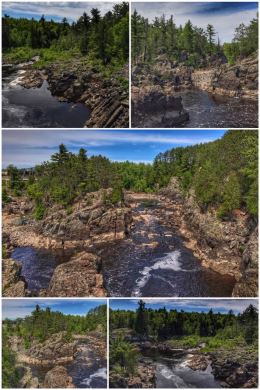
Just south of Duluth lies the St. Louis River Estuary, the largest U.S. tributary to Lake Superior and the largest freshwater estuary in North America. The Western Waterfront Trail provides almost 5 miles of accessible trail along the banks of the St. Louis River — and is the starting point of the Willard Munger Trail, a 70-mile rail-trail that is considered one of the most scenic of all trails in the state — traveling between the cities of Hinckley, Willow River, Moose Lake, Barnum, Carlton, and Duluth. The trail passes near Banning State Park, General C.C. Andrews State Forest, and Jay Cooke State Park. The northeast portion of the trail provides scenic views of the St. Louis River and the twin ports of Duluth and Superior.
We hiked a portion of the trail near Carlton, not far from our nice little KOA campground in Cloquet (about 20 miles southwest of Duluth), and adjacent to Jay Cooke State Park. One of the highlights of the trail in this area is an old trestle that passes over the St. Louis River, as shown in the collage.

The trail follows the historic 19th-century route of the Lake Superior and Mississippi Railroad (later Northern Pacific) that carried goods and passengers between the Twin Cities (of Minneapolis and St. Paul) and Duluth, mostly following the St. Louis River. When Burlington Northern was formed in the 1970s, the rail corridor became obsolete because of a better, parallel track…. leading to abandonment and the chance to railbank the corridor. The trail is perfect for bikers, walkers, and in-line skaters in the warmer months — and for snowmobilers and cross-country skiers in the winter. The trail is named for Willard Munger (1911-1999), a Minnesota politician who was a member of the Minnesota House of Representatives from the Duluth area. He holds the record as the longest-serving member of the House — at more than 42 years and seven months.
Another Duluth and Minnesota fun fact: Iron was king for many years. The state had three main iron ranges in the northeast portion of the state — the Cuyuna, Mesabi, and Vermilion. Today, only the Mesabi Range still has iron ore/taconite mining taking place. Duluth was not technically part of the Iron Range, but served as a destination and port for much of the iron produced — shipped to the port via the Duluth, Missabe and Iron Range Railway (DM&IR). Iron pellets were then shipped via the Great Lakes to steel towns such as Cleveland, Erie, Toledo, and others.

The next day, we headed up the North Shore on our own to see and experience the vastness of Lake Superior. As we drove north, we watched the temperature continue to drop… into the mid-40s — in June!
As you drive north from Duluth on Highway 61 (An All American Road on its own right), make sure you turn off toward the right onto the North Shore Scenic Drive. The views of Lake Superior are amazing — and the immenseness of the lake daunting.
Along that route, we stopped at a wonderful little shop in Knife River, located about 20 miles north of Duluth: Russ Kendall’s Smokehouse. This place is loved by locals and tourists and offers all sorts of local goodies (including local wild rice and maple syrup), but the specialty is smoked fish — done using the same methods used for thousands of years by the Anishinaabe. .. a two-day marathon of salt brine and maple wood smoke.
We spent a delightful time with Gordy Olson (husband to Kristi, Russ Kendall’s daughter), the third-generation of the family to run the business. He convinced us to try some of the smoked wild-caught Alaskan salmon, wrapped first in paper and then in newspaper. All the other smoked fish they sell is locally caught. W.T. Kendall opened the smoke house in Knife River in 1908 and his son Russ rebranded and grew the business when he took it over in 1952. Kristi and Gordy took over the business in 2007… and now their children work in the business, so another generation is learning this lost art.

We continued up the North Shore, back on Highway 61, up to Split Rock Lighthouse, which is touted as the most photographed lighthouse in the U.S. Located about 20 miles northeast of Two Harbors (and about 50 miles northeast of Duluth), the lighthouse is located in a state park, but the to see the actual building, light-keeper quarters, and other features on the grounds, you have to pay admission to the Minnesota Historical Society — and the price is well worth it! We started with the film about the lighthouse and then headed out to wander the cliffs and climb up into the lighthouse. (You can also take a guided tour, but we skipped that to do our own thing.)
The fall storms on Lake Superior are pretty famous for strong (gale-force) winds and powerful, crashing waves… and a particularly bad November that wrecked (sank or damaged) nearly 30 ships in 1905 prompted the construction of the lighthouse. One of these shipwrecks, the Madeira, is located on the lake bottom just north of the lighthouse. When the U.S. Lighthouse Service completed Split Rock Light Station in 1910, it primarily served the massive freighters hauling iron ore mined in northern Minnesota (the “Iron Range”). For the first 20 years, it was only accessible by boat, but in 1924 the North Shore Highway was extended past the lighthouse, and in the 1930s, the keepers reported spending parts of their day with tourists. in 1969, the lighthouse was decommissioned and deeded to the state. In 2011, the Split Rock Lighthouse was listed as a National Historic Landmark. Besides the lighthouse (lighted with a bivalve Fresnal lens built in Paris), the light station also had a fog signal that could be heard for five miles; it was used when visibility was extremely poor.

Besides the main buildings of the light station, which have been preserved wonderfully, visitors can also hike to several areas on the property — including the Hoist and Derrick Ruins (which is how they brought all the original building materials up the steep 133-foot cliff), Tram House and Tramway Ruins (a rail system built to carry supplies and used until the road was built), and Boathouse and Dock (both destroyed by storms).
From various locations along our hiking around the grounds, we witnessed the vastness of this truly superior lake. And watching the waves crashing on this quiet June day, one could only wonder what it looks like in those November storms. Speaking of those storms and shipwrecks, every November 10 the lighthouse comes back online and emits a light in memory of the SS Edmund Fitzgerald, the largest Laker at the time, which sank on that date in 1975 on the eastern side of the lake, in Canadian waters, carrying iron ore pellets from Duluth en-route to Detroit — caught in a fierce storm with hurricane-force winds and waves up to 35 feet high. All 29 crew members perished; their bodies never recovered.
From the light station, one can hike about 3 miles of shoreline in the state park, or jump onto the paved Gitchi Gami State Trail and hike or bike down to Gooseberry Falls State Park. (When the trail is completed, it will be a paved trail connecting Two Harbors to Grand Marais along the North Shore of Lake Superior, stopping through five state park.) Along the trail, one can also connect with the North Shore State Trail, a 146-mile unpaved trail passes through the largely undeveloped backcountry between Duluth and Grand Marais.

We ended the day by driving down to Gooseberry Falls State Park, located in Silver Creek, and about 13 miles northeast of Two Harbors (and 7 miles southwest of Split Rock Lighthouse). Preserved by the state in the early 1930s and opened as a state park in 1937, this 1,687-acre park protects the mouth of the Gooseberry River and includes Upper, Middle, and Lower Gooseberry Falls (the main attractions), as well as Fifth Falls, and beautiful forests of mixed evergreens, aspens, and birch trees. The landscape around the main falls, which is a world of basalt rock, formed by lava flow more than a billion years ago and eroded over time by the water flow, is truly spectacular — and the hike down to the main falls from the visitor center is fairly short and easy.
Much of the original work completed in the park was done by men from the Civilian Conservation Corps (CCC), under supervision from the Minnesota Central Design Office of the National Park Service. CCC crews built the park’s stone and log buildings and the 300-foot long “Castle in the Park” stone retaining wall. They also laid out the original campground, picnic grounds, and trails.
We decided to hike one of those trails — the Fifth Falls Trail, a 2-mile loop trail that travels along both banks of the Gooseberry River. Trail guides call this hike rugged, but we found it moderate — with some climbing up and around rocks. In the end, we found this trail to be one of our most favorites of all the hundreds of trails we have hiked thus far. It’s hard to explain, but this trail is simply a most wonderful walk into the woods, along with the sites and sounds of the river always nearby.
For part of the hike, the trail is also part of the Superior Hiking Trail — a 310-mile lightly developed trail in northeastern Minnesota that follows the ridge-line overlooking Lake Superior for most of its length from Duluth to the Canadian border. (The Superior Hiking Trail has trailheads about every 5-10 miles, making this trail ideal for day hikes, backpacking, thru-hiking, and trail running.)

As we end our adventures in Minnesota and head for Wisconsin, we can’t help but have a kind of love-hate with Minnesota. We loved so much of the open and green spaces, the amazing number and variety of lakes, and even the surprise of seeing the diversity of people in the Rochester and Duluth areas. And it was finally in Minnesota in which we encountered some of the best spring weather, with lots of sunshine and blooming lilacs and wildflowers. Voyageurs National Park and Lake Superior was truly great places to see and explore. And the people of the state quite friendly and helpful. BUT, we hated fighting off the ticks from our daily hikes and the blood-thirsty swarms of mosquitoes we found on the trails and in our campgrounds; these pests were relentless. In the end, of course, we were glad to have visited Minnesota — but next time we may visit in the fall!