
We left Grand Junction on the Western Slope, and headed back up toward the great Rocky Mountains, with a quick stop in Glenwood Springs so that Ran could visit an old friend who lives in the area.
The Western Slope of Colorado contains everything west of the Continental Divide in the Rocky Mountains. The Western Slope contains only about 10 percent of Colorado’s residents and 33 percent of the state’s land (including some of the state’s best agricultural lands and most popular recreation areas), but is also home to about 70 percent of the state’s water.
Our time in Glenwood Springs was especially eventful because Ran met up with an old high-school friend; they had re-connected with Facebook, but had not seen each other in about 40 years! Phil and his wife Lisa are amazing folks who also have an RV and we hope to visit with them in multiple locations over the upcoming years.

Glenwood Springs is most certainly a resort town, known for its hot springs and surrounded by the White River National Forest.
While in the area, we took advantage of some decent weather by getting on our bicycles and hitting another rail-trail. The Rio Grande Trail is a 42-mile paved trail that connects Glenwood Springs to Aspen, with sections of the trail following the Roaring Fork River. The trail follows the Aspen Branch of the former rail corridor of Denver and Rio Grande Western Railroad (D&RGW) — the same railroad that amazingly built a rail line through the Black Canyon in southwest Colorado.
We parked at Two Rivers Park in Glenwood Springs and headed up toward Carbondale. The early parts of the trail actually parallel the old rail-bed — with the railroad ties and tracks still in place; later, the trail moves onto the old railway right-of-way. We ended up biking about 14 miles.
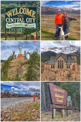
We next traveled up to the Idaho Springs area, staying at a campground close to Central City — a historic mining town founded in the mid-1800s during the Pike’s Peak Gold Rush, and known as the Richest Square Mile on Earth… with 17,000 mining claims made in the area. Today, the town focuses on tourism, with a restored downtown, and multiple casinos.
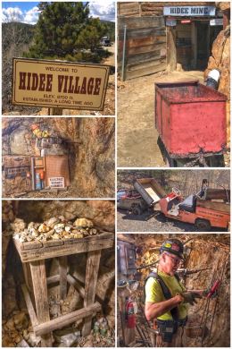
The whole area is also littered with abandoned mines and old mining operations, partly because miners sadly discovered it was extremely difficult to get the Colorado gold as the ore had to be smelted to get to the gold. We, of course, found the one exception: Hidee Gold Mine, which turned from mining to tourism, and offers wonderfully informative tours down into the mine.
The Hidee Mine sits in the heart of the Virginia Canyon – Glory Hole Area, part of that richest square mile. Specimen quality Pyritic gold ore was the principal product. The mines in this area all told produced more than $5 billion in gold and silver since 1859.
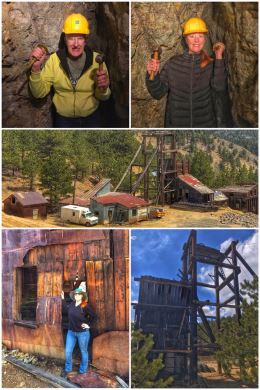
The Hidee was once an operating mine, but since the 1980s, it has moved to being more of an educational/tourist attraction. The Hidee is currently operated by Mark Greaves and Chris Stone of Hidee Gold Mine Tours LLC, with the advice and help from their long time mentor and former mine owner Ed Lewandowski.
We had a wonderful one-hour tour with James, our guide. The tour takes you through the main tunnels and down into the main vein, where we both did the one-armed jack (hammer and chisel) approach to finding our gold. Along the way, James shared information about the process of mining, including the miners, the tools, and the technology…. as well as some of the superstitions, such as the Tommyknockers — gnome-like characters that the Cornish miners believed protected them from collapses and cave-ins, as well as helping them find the gold veins. (Miners would leave offerings of food and other items in order to secure the good graces and protection of the Tommyknockers.)
We ended the time at Hidee, walking around to the ruins of yet another mine — the Notaway Mine — shown in the collage above.
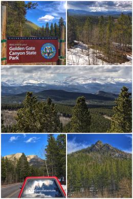
Next up was some hiking at the Golden State Canyon State Park, located about 10 miles northeast of Central City (and 15 miles northwest of Golden). The park includes more than 12,000 acres of beautiful forests, rocky peaks, and aspen-rimmed meadows laced with miles of connecting trails — and offers camping; fishing and hunting; rock climbing; and multiple types of camping (including some full RV hookups and cabins and yurts). Elevations in the park range from 7,600 feet up to 10,400 feet.
We started at the visitor center, which has great exhibits, a small gift area, and helpful staff. A short nature trail that winds around the park’s trout show pond is located just outside the center — and is paved and fully accessible. All the main trails in the park are named after animals, and while we loved the idea of hiking the Burro Trail, it’s label as difficult led us in other directions. We ended up driving up to the Reverend’s Ridge Campground and hiking some of the Raccoon Trail, which includes access to Panorama Point — from which the middle picture in the collage was taken. While all the trails in the park are fairly short, because of the massive changes in elevation, ALL the trails are rated as either moderate or difficult… so be prepared!
The next day, we finally achieved our long-awaited goal of visiting Rocky Mountain National Park, the 37th national park we have visited on this amazing trip. We cannot emphasize enough one of the main goals of this trip — which is to inspire YOU to get out in nature… to a local park, a state park, or a national park… just get out in nature and celebrate this amazing land.
Rocky Mountain National Park, established in 1915 (the nation’s 10th park) and totaling 265,769 acres (making it one of the largest national parks), spans the Continental Divide (a
hydrological divide that determines the flow of the rivers and creeks either toward the Pacific or Atlantic), and protects mountains, forests, and alpine tundra. Massive glaciers shaped the meadows and peaks within the park. Typical of many other parks we have visited, it had a champion… Enos Mills, a naturalist, nature guide, and lodge owner, pushed hard for the area to become a national park. The park is surrounded by the Roosevelt National Forest, an 813,799-acre forest renamed to honor President Theodore Roosevelt (a true champion of protecting natural lands), as well as part of the Arapaho National Forest, 723,744-acre forest.
Rocky Mountain National Park offers visitors the unique experience of three ecosystems — montane (below 9,000 feet, with ponderosa pines), subalpine (9,000-11,400 feet, with spruce and fir), and alpine (11,400+ feet, tundra conditions).
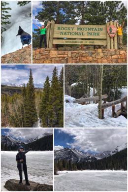
We started our adventure — yes, yes, you guessed it — at the Beaver Meadows Visitor Center, just west of Estes Park. We chatted with a ranger on the best trails to hike, especially given that some of the park was still closed because of snow. (Trail Ridge Road, a 48-mile road that spans the park, connecting Estes Park to Grand Lake on the western slope, is closed in the winter and much of spring.) We also watched the video and bought our park magnet.
Based on the ranger’s recommendations, we decided to spend time in two parts of the park, starting first at Bear Lake, located in the middle — and south of the visitor center. The area surrounding the lake was completely snowed in (and the lake itself still partially frozen), as can be seen in the first set of photos. We hiked the Bear Lake Loop (about .5 miles) and then headed over to Alberta Falls (about a 2-mile RT from Bear Lake). We loved the vistas as we walked around Bear Lake — and seeing Alberta Falls still partially frozen was also a treat… as were a pair of Stellar Jays that entertained us as we rested before beginning our hike back to Bear Lake.
Other shorter hikes in the area include the Nymph Lake, Dream Lake, Emerald Lake trails. Longer hikes include Bierstadt Lake, Fern Lake, and Lake Helene trails. The hiking in the snow was a bit hairy, but once again our hiking poles came in handy for keeping us balanced (most of the time).

From Bear Lake, we headed to the Fall River area to hike up the Old Fall River Road (closed to traffic from October through June) to see Chasm Falls. Jen was feeling the altitude and stayed back while Ran hiked up to the falls (a 2.2-mile trail); both had wonderful experiences as Jen got to see a momma moose and her juvenile moose up close and personal and Ran got to be alone in the serenity of a beautiful waterfall.
Speaking of animals, on our way out of the park, we also saw a herd of elk and a small group of bighorn sheep! Other wildlife that can be found in the park include deer, black bears, marmots, coyote, and pika.
Other hikes in the the Fall River area of the park include Beaver Mountain Loop (5 miles), Crystal Lake (8 miles), Lawn Lake (6 miles), and Gem Lake (1.7 miles).
There is so much more of the park that can and should be explored. (The park is so huge is has FOUR visitor centers.)
From here, we headed to a campground east of Denver, partly a stopping place so we could fly back to the San Diego area and spend a weekend celebrating the life of Jen’s mom.