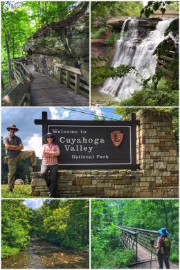
Because of stormy weather, we only got to spend one day at this beautiful national park, but we packed a LOT into the one day!
The 32,572-acre Cuyahoga Valley National Park only became a national park in 2000 — but it had been a national recreation area since 1974. It preserves the rural landscape along 22 miles of the Cuyahoga River between Cleveland and Akron.
The name of the river and the valley comes from the Mohawk Indians — Ka-ih-ogh-ha, which translates into “crooked river.” And it is indeed a crooked river, twisting and turning for 90 miles through the valley whereas that same distance (between Cleveland and Akron) by straight line is only about 30 miles. Interestingly, the Cuyahoga River was one of the most polluted rivers in the U.S. — even catching fire at least 13 times — leading it to be the poster child for environmental reform in the 1970s. Amazingly, earlier this year, the American Rivers conservation association named the Cuyahoga River of the Year in honor of “50 years of environmental resurgence.”
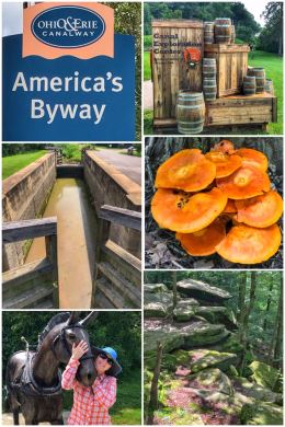
Back in the early 1800s, the Ohio & Erie Canal was constructed parallel to (and partly watered by) the Cuyahoga River — part of a growing canal system in which mules pulled boats through canals (and canal locks) — moving all sorts of products (including agricultural, iron ore, coal, pork, cheese, wool, and whiskey) to markets in the east. (And eastern markets could then more easily ship products to the west.) The canal traveled for 110 miles from Cleveland to New Philadelphia, Ohio. As mentioned in a previous post, the canals were a vital form of transportation for about 30 years until the railroad emerged as a better way to transport goods — and people.
We started our adventure in the national park at the Boston Store Visitor Center, centrally located just north of the town of Peninsula. We chatted with a ranger about hikes and the best things to do in one day — and picked up a magnet for our collection. Based on the ranger’s advice, along with our previous research, we decided on first tackling some hiking, starting with the park’s two waterfalls.
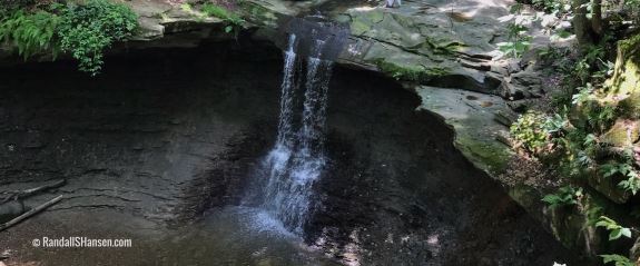
We ventured first to Blue Hen Falls, which is about a 3-mile (RT) hike from the visitor center… but there is also a parking lot directly across from the trailhead to the falls, though the park service warns that it does fill up quickly. We had no problem parking there that day. The hike down to the falls is short (about .5 miles), but steep — and with some uneven footing. But the 15-foot waterfall, shown in the cover photo for this post, is quite lovely and worth the effort.
We then traveled up to Brandywine Falls, a 60-foot waterfall and one of the park’s top attractions. This parking lot fills during peak times, though it was definitely not crowded when we visited. We decided to not only do the short hike down to the falls, but also hike the Brandywine Falls Gorge Loop Trail (a 1.4-mile loop), which follows the edge of the gorge (partly along the Bike & Hike paved trail), eventually taking you down to creek level before returning back up to the parking lot. Along the way, you’ll learn not only about the falls, but also about the now-gone, but once bustling Village of Brandywine (which included a sawmill, whiskey distillery, gristmill, woolen mill, and a dozen houses).
Side note: The Bike & Hike Trail provides 16 miles of paved trail through the park — and connects to the nearly 100-mile crushed-rock Ohio & Erie Towpath Trail.

The second half of our visit started with a stop in the Ritchie Ledges Area (named after a farmer who once owned the land), which offers interesting vista of massive sandstone cliffs formed more than 300 million years ago when this area of the park was covered by an ancient sea. Melting glaciers helped to form what are now captivating ledges.
Several trails are in this area, but you should definitely consider hiking the Ledges Trail, a 2.2-mile loop that circles above and at the base of the Ledges. We chose just to hike to the overlook and view the Ledges from the top and side. Other trails in this area include the Haskell Run (.5-mile loop), Forest Point Trail (.5-mile loop), and Pine Grove Trail (2.2-mile loop).
We ended our visit with a little canal history, stopping at the Canal Exploration Center, a National Historic Landmark located in a building that once housed a tavern and store — a rest stop along the canal. Besides the exhibits in the center, Lock 38 is located here. Lock 38 is one of the few restored and working locks along the Ohio & Erie Canal — and one of the 44 that dealt with the 395-foot rise in elevation from Cleveland to Akron. The elevation change is part of a continental divide in Ohio (in which in the northern part of the divide, the rivers flow to Lake Erie, while in the southern part of the divide, the rivers flow to the Ohio river.).

We decided to exit the park by taking Tinkers Creek Road eastward, allowing us to stop at the Tinkers Creek Gorge Scenic Overlook and Bridal Veil Falls, both part of the Cleveland Metroparks system.
Tinker’s Creek travels 28 miles and is the largest tributary that feeds the Cuyahoga River. The creek drops a dramatic 220 feet over a course of two miles and has carved out a steep, walled gorge. The gorge was declared a National Natural Landmark in 1967. The overlook is nice, but the trees so overgrown that the creek is barely visible.
We then traveled down to the Bridal Veil parking area. (The trailhead is directly across the street from the parking area.) The .3-mile trail takes you along Deerlick Creek, through hardwoods and hemlocks, down a boardwalk and steps, before leading to a viewing area of Bridal Veil Falls. The falls are only about 15′ high, but includes numerous levels of shale ledges, each showcasing a different level of erosion, and which fan out — creating a beautiful, cascading, veil-like effect.
If the weather had been nicer while we were in the area, we would have taken a second day at the national park to ride the Cuyahoga Valley Scenic Railroad, which runs between Cleveland and Akron and offers excursions year-round — with special emphasis on the national park. Passengers can choose from a variety of seating options including coach, table top, first class, lounge, upper dome, executive class, or suites — and a day pass allows you to get on and off as you like. The railroad is a not-for-profit organization operating in partnership with Cuyahoga Valley National Park and dedicated to the preservation of passenger rail transportation in Cuyahoga Valley and the historic Ohio & Erie Canalway.
